Three Sisters may refer to:
Green River may refer to:

Devils Tower is a butte, possibly laccolithic, composed of igneous rock in the Bear Lodge Ranger District of the Black Hills, near Hulett and Sundance in Crook County, northeastern Wyoming, above the Belle Fourche River. It rises 1,267 feet above the Belle Fourche River, standing 867 feet from summit to base. The summit is 5,112 feet above sea level.
Tor, TOR or ToR may refer to:
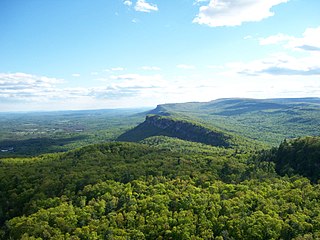
The Shawangunk Ridge, also known as the Shawangunk Mountains or The Gunks, is a ridge of bedrock in Ulster County, Sullivan County and Orange County in the state of New York, extending from the northernmost point of the border with New Jersey to the Catskills. The Shawangunk Ridge is a continuation of the long, easternmost section of the Appalachian Mountains; the ridge is known as Kittatinny Mountain in New Jersey, and as Blue Mountain as it continues through Pennsylvania. This ridge constitutes the western border of the Great Appalachian Valley.
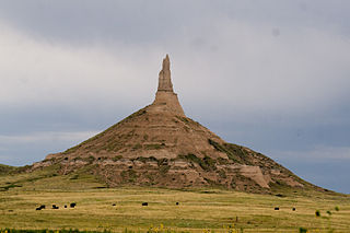
Chimney Rock is a prominent geological rock formation in Morrill County in western Nebraska. Rising nearly 300 feet (91 m) above the surrounding North Platte River valley, the peak of Chimney Rock is 4,228 feet (1,289 m) above sea level. The formation served as a landmark along the Oregon Trail, the California Trail, and the Mormon Trail during the mid-19th century. The trails ran along the north side of the rock, which remains a visible landmark for modern travelers along U.S. Route 26 and Nebraska Highway 92. Chimney Rock National Historic Site was designated in 1956 and is an affiliated area of the National Park Service, operated by History Nebraska.

Pompeys Pillar National Monument is a rock formation located in south central Montana, United States. Designated a National Monument on January 17, 2001, and managed by the U.S. Bureau of Land Management in conjunction with The Friends of Pompeys Pillar, it consists of only 51 acres (21 ha), making it one of the smallest National Monuments in the U.S.

Tower Rock, also known as Grand Tower, is a rock formation and landmark island in the Mississippi River, in Brazeau Township, Perry County, Missouri, near the town of Wittenberg, Missouri, and across the river from Grand Tower, Illinois. It was listed on the National Register of Historic Places in 1970.

Tuttle Creek Lake is a reservoir on the Big Blue River 5 miles (8 km) north of Manhattan, in the Flint Hills region of northeast Kansas. It was built and is operated by the Army Corps of Engineers for the primary purpose of flood control. Secondary functions of the project include release of water stores to maintain barge traffic on the Mississippi River during seasons of drought, maintenance of a multi-use conservation pool for fish and wildlife enhancement and recreation, and release of sufficient water in droughts to maintain water quality for downstream communities.
Hanging Rock may refer to:

Wiconisco Creek is a tributary of the Susquehanna River in Schuylkill and Dauphin counties, Pennsylvania, in the United States. It is approximately 45.5 miles (73.2 km) long.

Bald Eagle Mountain – once known locally as Muncy Mountain – is a stratigraphic ridge in the Ridge-and-Valley Appalachians of central Pennsylvania, United States, running east of the Allegheny Front and northwest of Mount Nittany. It lies along the southeast side of Bald Eagle Creek and south of the West Branch Susquehanna River, and is the westernmost ridge in its section of the Ridge-and-Valley Appalachians. The ridge line separates the West Branch Susquehanna Valley from the Nippenose and White Deer Hole valleys, and Bald Eagle Valley from Nittany Valley.

Tussey Mountain is a stratigraphic ridge in central Pennsylvania, United States, trending east of the Bald Eagle, Brush, Dunning and Evitts Mountain ridges. Its southern foot just crosses the Mason–Dixon line near Flintstone, Maryland, running north 130 km (80 mi) to the Seven Mountains of central Pennsylvania, near Tusseyville, making it one of the longest named ridges in this section of the Ridge-and-valley Appalachians. The ridge line separates Morrison Cove from the Woodcock Valley and Friends Cove from the Black Valley. Tussey Mountain lies in, and the ridge line forms parts of the borders of, Centre, Blair, Bedford and Huntingdon counties.
Wilkins Peak is a small mountain located in Sweetwater County, Wyoming, between the cities of Green River and Rock Springs. It is primarily used for radio and television station transmitters, but it also serves radio needs of the FAA, EMS, and local businesses such as Questar Gas. In 2003, a tower on the peak was knocked down by a vehicle delivering propane to customers. The tower was owned by Wyoming Public Radio and was serving the local area with programming from National Public Radio. There are numerous access roads to the peak and it is not gated and open year-round, weather permitting. Along with the radio uses, the mountain is also a popular location for mountain biking and hiking. The mountain contains geology typical of its location in southwestern Wyoming.
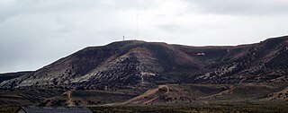
White Mountain is a long mountain located in central Sweetwater County, Wyoming, near the cities of Rock Springs and Green River. The mountain is part of the Green River Formation, and contains communications towers that serve a number of purposes. Hundreds of carved figures also dot the sandstone cliffs at the White Mountain Petroglyph site and range from 200 to 1000 years old. Pilot Butte, located on top of White Mountain, is accessible from roads on the mountain.

Nescopeck Mountain is a ridge in Columbia County and Luzerne County, in Pennsylvania, in the United States. Its elevation is 1,594 feet (486 m) above sea level. The ridge is a forested ridge, with at least two types of forest and two systems of vernal pools. It is a very long and unbroken ridge with two water gaps: one carved by Catawissa Creek and one carved by Nescopeck Creek. This later gap was exploited as a transportation corridor with the construction of the Lehigh & Susquehanna Turnpike between the respective frontier communities at Lausanne Landing and Nescopeck in 1805 connecting the newly developing Wyoming Valley with Philadelphia and the Delaware River valley; cutting off over 100 miles between Philadelphia and Wilkes-Barre. Today's Route PA 93 derives from this historic pack mule road.

Tower Rock State Park is a state park near the community of Cascade in the U.S. state of Montana in the United States. The centerpiece of the park is Tower Rock, a 424-foot (129 m)-high rock formation which marks the entrance to the Missouri River Canyon in the Adel Mountains Volcanic Field. It was well known to Native Americans, and considered a sacred place by the Piegan Blackfeet. Tower Rock received its current name when Meriwether Lewis of the Lewis and Clark Expedition visited the site in 1805. Railroad and highway development in the late 1800s and 1900s skirted Tower Rock, but the landform itself remained pristine. The 87.2 acres (0.353 km2) encompassing Tower Rock was added to the National Register of Historic Places on March 18, 2002. The 140-acre (0.57 km2) Tower Rock State Park was created around the National Historic Site in 2004.
McCarty Hill is a mountain in the Southern Tier of New York. It is located in Cattaraugus County, mostly in Little Valley and Great Valley, with portions in Ellicottville and Mansfield. In 1940, a 82-foot-6-inch-tall (25.15 m) steel fire lookout tower was built on the mountain. The tower ceased fire lookout operations and then officially closed in early 1989. In 1993, the tower was dismantled and removed, and replaced with a free standing communications tower.