As general terms, Indian Territory, the Indian Territories, or Indian country describe an evolving land area set aside by the United States Government for the relocation of Native Americans who held aboriginal title to their land. In general, the tribes ceded land they occupied in exchange for land grants in 1803. The concept of an Indian Territory was an outcome of the 18th- and 19th-century policy of Indian removal. After the Civil War (1861–1865), the policy of the government was one of assimilation.
The Trail of Tears was a series of forced relocations of Native Americans in the United States from their ancestral homelands in the Southeastern United States, to areas to the west that had been designated as Indian Territory. The forced relocations were carried out by government authorities following the passage of the Indian Removal Act in 1830. The relocated peoples suffered from exposure, disease, and starvation while en route to their new designated reserve, and many died before reaching their destinations. The forced removals included members of the Cherokee, Muscogee (Creek), Seminole, Chickasaw, Choctaw, and Ponca nations, as well as their African slaves. The phrase "Trail of Tears" originates from a description of the removal of many Native American tribes, including the infamous Cherokee Nation relocation in 1838.

The Royal Proclamation of 1763 was issued by King George III on October 7, 1763, following Great Britain's acquisition of French territory in North America after the end of the French and Indian War/Seven Years' War. This proclamation rendered all land grants given by the government to British subjects who fought for the Crown against France worthless. It forbade all settlement west of a line drawn along the Appalachian Mountains, which was delineated as an Indian Reserve.

The Ojibwe, Ojibwa, Chippewa, or Saulteaux are an Anishinaabe people of Canada and the United States. They are one of the most numerous indigenous peoples north of the Rio Grande. In Canada, they are the second-largest First Nations population, surpassed only by the Cree. In the United States, they have the fifth-largest population among Native American peoples, surpassed in number only by the Navajo, Cherokee, Choctaw and Sioux.

Oil Springs Reservation or Oil Spring Reservation is an Indian reservation of the federally recognized Seneca Nation that is located in southwestern New York, United States. As of the 2010 census, the Indian reservation had one resident; in 2005 no tribal members had lived on the property. The reservation covers about one square mile (2.6 km2), divided between the present-day counties of Allegany and Cattaraugus. The reservation is northwest of the village of Cuba. It is bordered by the Town of Cuba and the Town of Ischua.
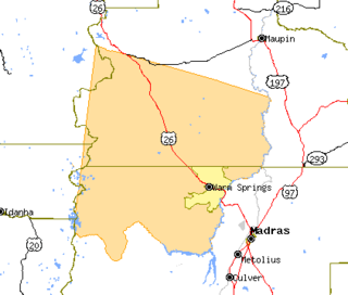
The Warm Springs Indian Reservation consists of 1,019 square miles (2,640 km2) in north-central Oregon, in the United States, and is occupied and governed by the Confederated Tribes of Warm Springs.

The Assembly of First Nations (AFN) is an assembly, modelled on the United Nations General Assembly, of First Nations represented by their chiefs. It emerged from and replaced the Canadian National Indian Brotherhood in the early 1980s. The aims of the organization are to protect and advance the aboriginal and treaty rights and interests of First Nations in Canada, including health, education, culture and language.

An Indian reservation is a legal designation for an area of land managed by a federally recognized Native American tribe under the U.S. Bureau of Indian Affairs rather than the state governments of the United States in which they are physically located. Each of the 326 Indian reservations in the United States is associated with a particular Native American nation. Not all of the country's 567 recognized tribes have a reservation—some tribes have more than one reservation, while some share reservations. In addition, because of past land allotments, leading to some sales to non–Native Americans, some reservations are severely fragmented, with each piece of tribal, individual, and privately held land being a separate enclave. This jumble of private and public real estate creates significant administrative, political, and legal difficulties.
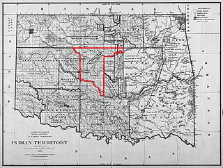
The Unassigned Lands in Oklahoma were in the center of the lands ceded to the United States by the Creek (Muskogee) and Seminole Indians following the Civil War and on which no other tribes had been settled. By 1883 it was bounded by the Cherokee Outlet on the north, several relocated Indian reservations on the east, the Chickasaw lands on the south, and the Cheyenne-Arapaho reserve on the west. The area amounted to 1,887,796.47 acres.
Suzerainty is any relationship in which one region or nation controls the foreign policy and international relations of a tributary state, while allowing the tributary nation to have internal autonomy.
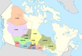
Treaty 6 is the sixth of seven numbered treaties that were signed by the Canadian Crown and various First Nations between 1871 and 1877. Specifically, Treaty 6 is an agreement between the Crown and the Plains and Woods Cree, Assiniboine, and other band governments at Fort Carlton and Fort Pitt. Key figures, representing the Crown, involved in the negotiations were Alexander Morris, Lieutenant Governor of the North-West Territories; James McKay, The Minister of Agriculture for Manitoba; and W.J. Christie, the Chief Factor of the Hudson's Bay Company. Chief Mistawasis and Chief Ahtahkakoop represented the Carlton Cree.

William McKendree Springer was a United States Representative from Illinois.
Wasco-Wishram are two closely related Chinook Indian tribes from the Columbia River in Oregon. Today the tribes are part of the Confederated Tribes of Warm Springs living in the Warm Springs Indian Reservation in Oregon and Confederated Tribes and Bands of the Yakama Nation living in the Yakama Indian Reservation in Washington.

The Little Traverse Bay Bands of Odawa Indians (LTBBOI) is a federally recognized Native American tribe of Odawa. A large percentage of the more than 4000 tribal members continue to reside within the tribe's traditional homelands on the northwestern shores of the state of Michigan's Lower Peninsula. The historically delineated reservation area, located at 45°21′12″N 84°58′41″W, encompasses approximately 336 square miles (870 km2) of land in Charlevoix and Emmet counties. The largest communities within the reservation boundaries are Harbor Springs, where the tribal offices are located; Petoskey, where the Tribe operates the Odawa Casino Resort; and Charlevoix.
Lone Wolf v. Hitchcock, 187 U.S. 553 (1903), was a United States Supreme Court case brought against the US government by the Kiowa chief Lone Wolf, who charged that Native American tribes under the Medicine Lodge Treaty had been defrauded of land by Congressional actions in violation of the treaty.
On the eve of the American Civil War in 1861, a significant number of Indigenous peoples of the Americas had been relocated from the Southeastern United States to Indian Territory, west of the Mississippi. The inhabitants of the eastern part of the Indian Territory, the Five Civilized Tribes, were suzerain nations with established tribal governments, well established cultures, and legal systems that allowed for slavery. Before European Contact these tribes were generally matriarchial societies, with agriculture being the primary economic pursuit. The bulk of the tribes lived in towns with planned streets, residential and public areas. The people were ruled by complex hereditary chiefdoms of varying size and complexity with high levels of military organization.