
The Muscogee, also known as the Mvskoke, Muscogee Creek or just Creek, and the Muscogee Creek Confederacy, are a group of related Indigenous peoples of the Southeastern Woodlands in the United States. Their historical homelands are in what now comprises southern Tennessee, much of Alabama, western Georgia and parts of northern Florida.

Muscogee County is a county located on the central western border of the U.S. state of Georgia named after the Muscogee that originally inhabited the land with its western border with the state of Alabama that is formed by the Chattahoochee River. As of the 2020 census, the population was 206,922. Its county seat and only city is Columbus, with which it has been a consolidated city-county since the beginning of 1971.
Carroll County is a county in the West Central region of the State of Georgia. As of the 2020 census, its population was 119,148. Its county seat is the city of Carrollton. Carroll County is included in the Atlanta–Sandy Springs–Roswell metropolitan statistical area and is also adjacent to Alabama on its western border.

The Ocmulgee River is a western tributary of the Altamaha River, approximately 255 mi (410 km) long, in the U.S. state of Georgia. It is the westernmost major tributary of the Altamaha. It was formerly known by its Hitchiti name of Ocheese Creek, from which the Creek (Muscogee) people derived their name.

Ocmulgee Mounds National Historical Park in Macon, Georgia, United States preserves traces of over ten millennia of culture from the Indigenous peoples of the Southeastern Woodlands. Its chief remains are major earthworks built before 1000 CE by the South Appalachian Mississippian culture These include the Great Temple and other ceremonial mounds, a burial mound, and defensive trenches. They represented highly skilled engineering techniques and soil knowledge, and the organization of many laborers. The site has evidence of "12,000 years of continuous human habitation." The 3,336-acre (13.50 km2) park is located on the east bank of the Ocmulgee River. Macon, Georgia developed around the site after the United States built Fort Benjamin Hawkins nearby in 1806 to support trading with Native Americans.
Alexander McGillivray, also known as Hoboi-Hili-Miko, was a Muscogee (Creek) leader. The son of a Muscogee mother, Sehoy II, and a Scottish father, Lachlan McGillivray, he was literate and received an education in the British colonies. His understanding of both Muscogee and European culture combined with his father's trading contacts allowed him to become the richest Creek of his time.

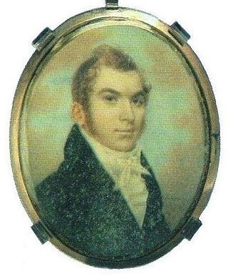
John Ridge, born Skah-tle-loh-skee, was from a prominent family of the Cherokee Nation, then located in present-day Georgia. He went to Cornwall, Connecticut, to study at the Foreign Mission School. He met Sarah Bird Northrup, of a New England Yankee family, and they married in 1824. Soon after their return to New Echota in 1825, Ridge was chosen for the Cherokee National Council and became a leader in the tribe.
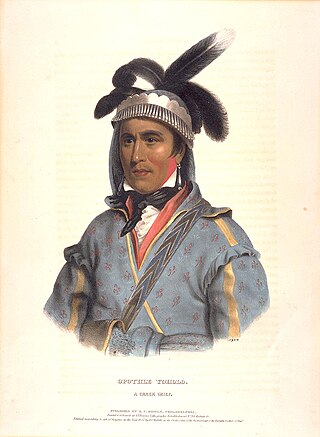
Opothleyahola was a Muscogee Creek Indian chief, noted as a brilliant orator. He was a Speaker of the Upper Creek Council and supported traditional culture.
The 1826 Treaty of Washington was a treaty between the United States and the Creek Confederacy, led by Opothleyahola. The Creek National Council ceded much of their territory bordering Georgia to the United States.

George McIntosh Troup was an American politician from the U.S. state of Georgia. He served in the Georgia General Assembly, U.S. House of Representatives, and U.S. Senate before becoming the 32nd Governor of Georgia for two terms and then returning to the U.S. Senate. A believer in expansionist Manifest Destiny policies and a supporter of native Indian removal, Troup was born to planters and supported slavery throughout his career. Later in his life, he was known as "the Hercules of states' rights."

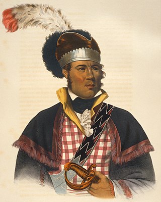
Menawa, first called Hothlepoya, was a Muscogee (Creek) chief and military leader. He was of mixed race, with a Creek mother and a fur trader father of mostly Scots ancestry. As the Creek had a matrilineal system of descent and leadership, his status came from his mother's clan.
William McIntosh, also known as Tustunnuggee Hutke, was one of the most prominent chiefs of the Muscogee Creek Nation between the turn of the 19th-century and his execution in 1825. He was a chief of Coweta tribal town and commander of a mounted police force. He became a large-scale planter, built and managed a successful inn, and operated a commercial ferry business.
Cusseta, also known as Kasihta, was a Peace Town of the Lower Towns, a division of the Muscogee Confederacy. It was located in what the Spanish called Apalachicola Province on the Chattahoochee River, then in what is now the state of Georgia near the Ocmulgee River, and finally again on the Chattahoochee River. It was one of the two major towns of the Lower Creek, with a population of 1,918 in 1832.
The Battle of Taliwa was fought in Ball Ground, Georgia, in 1755. The battle was part of a larger campaign of the Cherokee against the Muscogee Creek people, where a contingent of 500 Cherokee warriors led by war chief Oconostota defeated the Muscogee Creek people and pushed them south from their northern Georgia homelands, allowing the Cherokee to begin settling in the region.

McIntosh Reserve is an outdoor recreation area along the Chattahoochee River located in Carroll County, Georgia. The 527-acre (2.13 km2) park is operated by the Carroll County Recreation Department and supports outdoor activities including camping, hiking, fishing, and others. The park is open year-round, closing only on Thanksgiving, Christmas, and New Year's Day. McIntosh Reserve is named for William McIntosh Jr., a prominent Creek Indian leader
McIntosh Road is a historic Native American route in the northern part of the U.S. states of Alabama and Georgia. It was named for the prominent Creek Indian chief William McIntosh, a leader of the Lower Towns who helped to improve it in the early 19th century.
Chilly McIntosh was an important figure in the history of the Creek Nation. Born in Georgia to William McIntosh, chief of the Lower Creeks and his wife Eliza, he was the half-brother of D. N. McIntosh and the nephew of Roley McIntosh, another Creek chief.
The Treaty of Indian Springs, also known as the First Treaty of Indian Springs and the Treaty with the Creeks, is a treaty concluded between the Muscogee and the United States on January 8, 1821 at what is now Indian Springs State Park.
Acorn Creek is a stream in Carroll County in the U.S. state of Georgia, at an elevation of 666 feet (203 m) above mean sea level. It is a tributary to the Chattahoochee River with a discharge rate of 2.74 cfs.
Elizabeth Grierson was a 19th-century Muscogee woman from the Hillabee town in the Muscogee Nation, now present-day Alabama.

