Dhankuta is a hill town and the headquarter of Koshi Zone located in Dhankuta District of Eastern Nepal. According to 2011 Nepal census, it has population of 26,440 inhabitants.
Tri-City, Tricity or Tri-Cities may refer to:

Pokhara is a metropolitan city in Nepal, which serves as the capital of Gandaki Pradesh. It is the country's second largest city in terms of both population and area. The city also serves as the headquarters of Kaski District. Pokhara is located 200 kilometres west of the capital, Kathmandu. The altitude varies from 827 metres in the southern part to 1,740 metres in the north. The Annapurna Range, with three out of the ten highest mountains in the world — Dhaulagiri, Annapurna I and Manaslu — is within 15–35 mi (24–56 km) of the valley.

Mahakali was one of the fourteen zones located in the Far-Western Development Region of Nepal, covering an area of 6,205 km2 in the most western part of the country. It stretches along Nepal's far western border with India, marked by the Kali River or Mahakali River, which originates from Limpiyadhura, a tripoint between China India and Nepal which is at present occupied by Indian army since 1962 Sino India war.

Dhaulagiri was one of the fourteen zones which Nepal was divided into for administrative purposes, prior to the September 10, 2015 adoption of a new Constitution, which divided the nation instead into 7 provinces. It is in the Western Development Region of Nepal. Famous trekking areas like Mustang, Muktinath, Kali Gandaki valley and Mt Dhaulagiri fall in this zone. Dhorpatan Hunting Reserve, the only hunting reserve in Nepal is spread over Baglung and Myagdi Districts of this zone.

Baglung District, a part of Gandaki Pradesh, is one of the seventy-seven districts of Nepal. The district, with Baglung as its district headquarters, covers an area of 1,784 km2 (689 sq mi) and has a population (2011) of 268,613.

Syangja District, a part of Gandaki Pradesh, is one of the seventy-seven districts of Nepal. The district, with Syangja bazaar as its district headquarters, covers an area of 1,164 km2 (449 sq mi) and had a population of 289,148 It lies in the hilly region at an altitude ranging from about 300 meters along the banks of Kaligandaki river up to a couple of thousands meters above the sea level. It lies at about latitude 28°4'60 North and longitude 83°52'0 East.

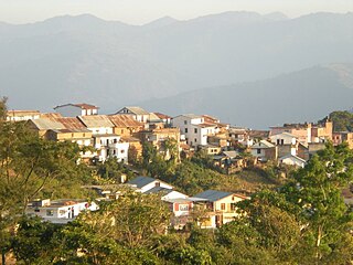
Baglung, is a municipality in western Nepal, 275 km west of Kathmandu. It is the administrative headquarters of Baglung District and Dhaulagiri Zone. Baglung serves as the major center for business, finance, education, service and healthcare for the people of mid-Kali Gandaki valley that encompass Beni, Jaljala, Baglung, Kushma, Kathekhola, Galkot, Phalewas and Jaimuni local bodies. The city is located at the cross-section of Kaligandaki corridor highway and midhill highway that transverse Nepal in north–south and east–west directions respectively.

Dhorpatan is a village in Nepal's Baglung District, 2,900 meters elevation in an east-west valley south of the Dhaulagiri mountain range in the Himalayas. It is the headquarters of Dhorpatan Hunting Reserve. There is a small community of indigenous Kham Magar people as well as Tibetan refugees.
Birendranagar is a city in Surkhet District in Karnali province of Nepal.
Beni is a Municipality and the district headquarters of Myagdi District in Dhaulagiri Zone, Nepal. Municipality was announced by merging the then Ratnechaur, Jyamrukot, Arthunge, Ghatan, Pulachaur, Singa village development committees since 18 May 2014.
Kushma is a municipality and the headquarters of Parbat District in Nepal. Kushma municipality was formed by merging thirteen village development committees Pang, Khurkot, Durlung, Shivalaya, Chuwa, Katuwa Chaupari, Pipaltari and Pakuwa on 18 May 2014.
Argal is a Village Development Committee in Baglung District in the Dhaulagiri Zone of central Nepal. It is located roughly 25 kilometres west of Baglung. At the time of the 1991 Nepal census it had a population of 2,148 and had 387 houses in the village.
Bihunkot is a Village Development Committee in Baglung District in the Dhaulagiri Zone of central Nepal. At the time of the 1991 Nepal census it had a population of 5,575 and had 1071 houses in the town.
Narayansthan is a village development committee in Baglung District in the Dhaulagiri Zone of central Nepal.It is located above the bank of Kali gandaki River. Now, it has become one of the major important place in baglung. They have planned to construct the domestic Airport. At the time of the 2011 Nepal census it had a population of 2,876 and had 781 houses in the town. The major castes living in the VDC are Brahman,Chhetry and Newar. There are 2 high schools - Janatadhan Higher School and Ganesh Secondary School and one campus. Krishna Gandaki Campus is at the premises of Janatadhan HSS. Ganesh Secondary School, one of the best schools in the region is known for its quality education movement. Established in 1957 [2014 BS] by Soldier Board (India), Ganesh Secondary School is one of the oldest schools. In 1964 [2021 BS], the Indian Soldier Board stopped its grant. Since there was no school support mechanism developed from the Government of Nepal, the school passed through many ups and downs. After Modern Education Act came in effect in 1971 BS [2028 BS], the school merged with Janatadhan Higher Secondary School. In 1980 [2037 BS], the school was reopened.
Banau is a village development committee in Parbat District in the Dhawalagiri Zone of central Nepal. At the time of the 1991 Nepal census it had a population of 1432 people living in 251 individual households.
Gupteswor cave is one of the major attractions of Kusma, Parbat. It is considered as one of the most amazing and longest caves in the nation of Nepal.

The National League is a club-level association football competition in Nepal. The champions secure qualification to a continental cup, previously the AFC President's Cup.
Aapchaur is a hill village in Gulmi District, central Nepal, roughly 10 kilometres northeast of Tamghas and 30 kilometres southwest of Baglung. Overlooking a river valley, this village area was the cradle of the Nepalese coffee industry when it was first planted by a Hindu holy man using seeds from Burma in 1937.
Galkot is a town in Baglung district, Nepal. It consists of several VDCs. Nearby cities include Gulmi and Pokhara. Its geographic coordinates are 28°13'24"N 83°25'29"E.