
This article is about the demographic features of the population of Bosnia and Herzegovina, including population density, ethnicity, education level, health of the populace, economic status, religious affiliations and other aspects of the population.

Republika Srpska is one of the two entities of Bosnia and Herzegovina, the other being the Federation of Bosnia and Herzegovina. It is located in the north and east of the country. Its largest city and administrative centre is Banja Luka, lying on the Vrbas river.
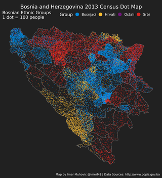
More than 96% of population of Bosnia and Herzegovina belongs to one of its three autochthonous constituent peoples: Bosniaks, Serbs and Croats. The term constituent refers to the fact that these three ethnic groups are explicitly mentioned in the constitution, and that none of them can be considered a minority or immigrant. The most easily recognizable feature that distinguishes the three ethnic groups is their religion, with Bosniaks predominantly Muslim, Serbs predominantly Orthodox Christians, and Croats Catholic.

Šamac is a town and municipality located in the northeastern part of the Republika Srpska, an entity of Bosnia and Herzegovina. As of 2013, the town has a population of 5,390 inhabitants, while the municipality has 17,273 inhabitants. It is situated on the right bank of the Sava river. Across the river is Slavonski Šamac in Croatia.
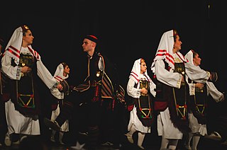
The Serbs of Bosnia and Herzegovina are one of the three constitutive nations of the country, predominantly residing in the political-territorial entity of Republika Srpska.
Kijevo is a Serbo-Croatian toponym that may refer to:

The Republika Srpska was a self-proclaimed proto-state in Southeastern Europe under the control of the Army of Republika Srpska during the Bosnian War. It claimed to be a sovereign state, though this claim was not recognized by the Bosnian government, the United Nations, or any other recognized state. For the first few months of its existence, it was known as the Serbian Republic of Bosnia and Herzegovina.
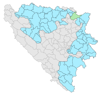
Under the "Law on Territorial Organization and Local Self-Government" adopted in 1994, Republika Srpska was divided into 80 municipalities. After the conclusion of the Dayton Peace Agreement, the law was amended in 1996 to reflect the changes to the entity's borders and now provides for the division of Republika Srpska into 64 municipalities.

This article is about the Demographic history of Bosnia and Herzegovina, and deals with the country's documented demographics over time. For an overview of the various ethnic groups and their historical development, see Ethnic groups in Bosnia and Herzegovina.

Istočno Sarajevo is de jure capital city of Republika Srpska entity of Bosnia and Herzegovina. It consists of a few suburban areas of pre-war Sarajevo which are now included in the Republika Srpska entity, and newly built areas. With an area of 1450 km2, Istočno Sarajevo is one of the largest administrative areas in the Balkans. As of 2013, it has a population of 61,516 inhabitants. Istočno Sarajevo is the largest city in Republika Srpska in terms of area, while it is in fifth place in terms of population. It is the only city of the entity that includes several municipalities: Istočna Ilidža, Istočno Novo Sarajevo, Pale, Istočni Stari Grad, Sokolac and Trnovo. It is separated from Sarajevo and Canton Sarajevo by the Inter-Entity Boundary Line (IEBL). The City Administration of East Sarajevo is located in the municipality of Istočno Novo Sarajevo, in Stefana Nemanje Street.

Trnovo is a town and municipality located in Sarajevo Canton of the Federation of Bosnia and Herzegovina, an entity of Bosnia and Herzegovina. As of 2013, it has a population of 1,830 inhabitants.

Trnovo is a municipality of the city of Istočno Sarajevo located in Republika Srpska, an entity of Bosnia and Herzegovina. As of 2013, it has a population of 2,050 inhabitants.

The Republic of Bosnia and Herzegovina was a state in Southeastern Europe, existing from 1992 to 1995. It is the direct legal predecessor to the modern-day state of Bosnia and Herzegovina.
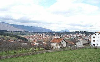
Kneževo, formerly Skender Vakuf is a town and municipality located in northwestern Republika Srpska, an entity of Bosnia and Herzegovina. As of 2013, it has a population of 9,793 inhabitants.

Kupres is a town and municipality located in Canton 10 of the Federation of Bosnia and Herzegovina, an entity of Bosnia and Herzegovina. As of 2013, it has a population of 5,057 inhabitants, while the town of Kupres has a population of 2,883 inhabitants.

The Croatian Republic of Herzeg-Bosnia was an unrecognised geopolitical entity and proto-state in Bosnia and Herzegovina. It was proclaimed on 18 November 1991 under the name Croatian Community of Herzeg-Bosnia as a "political, cultural, economic and territorial whole" in the territory of Bosnia and Herzegovina.
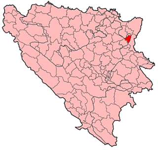
Sapna is a town and municipality located in Tuzla Canton of the Federation of Bosnia and Herzegovina, an entity of Bosnia and Herzegovina.

General elections were held in Bosnia and Herzegovina on 1 October 2006. They decided the makeup of Bosnia and Herzegovina's presidency as well as federal, entity, and cantonal governments. Voter turnout was 52.74%.

Independence Day is a public holiday observed in the Federation of Bosnia and Herzegovina held on 1 March to celebrate the independence of the Republic of Bosnia and Herzegovina from the Socialist Federal Republic of Yugoslavia in 1992. It is not observed in Republika Srpska, the other political entity of Bosnia and Herzegovina. The central state, Bosnia and Herzegovina, celebrates 25 November as Statehood Day.
The partition of Bosnia and Herzegovina was discussed and attempted during the 20th century. The issue came to prominence during the Bosnian War, which also involved Bosnia and Herzegovina's largest neighbors, Croatia and Serbia. As of 2021, the country remains one state while internal political divisions of Bosnia and Herzegovina based on the 1995 Dayton Agreement remain in place.


