
Ecuador, officially the Republic of Ecuador, is a country in northwestern South America, bordered by Colombia on the north, Peru on the east and south, and the Pacific Ocean on the west. Ecuador also includes the Galápagos Islands in the Pacific, about 1,000 kilometers (621 mi) west of the mainland. The country's capital and largest city is Quito.

Piura is a coastal department and region in northwestern Peru. The region's capital is Piura and its largest port cities, Paita and Talara, are also among the most important in Peru. The area is known for its tropical and dry beaches. It is the most populous department in Peru, its twelfth smallest department, and its fourth-most densely populated department, after Tumbes, La Libertad, and Lambayeque.
Tumbes is a coastal department and region in northwestern Peru bordering Ecuador. Due to the region's location near the Equator it has a warm climate, with beaches that are considered among the finest in Peru. Despite its small area, the region contains a wide variety of ecosystems. It is the smallest department in Peru and its third least populous department after Moquegua and Madre de Dios, but it is also its third most densely populated department, after La Libertad and Lambayeque.
The Battle of Puná, a peripheral engagement of Francisco Pizarro's conquest of Peru, was fought in April 1531 on the island of Puná in Ecuador. Pizarro's conquistadors, boasting superior weaponry and tactical skill, decisively defeated the island's indigenous inhabitants. The battle marked the beginning of Pizarro's third and final expedition before the fall of the Inca Empire.
Tumbes is a city in northwestern Peru, on the banks of the Tumbes River. It is the capital of the Tumbes Region, as well as of Tumbes Province and Tumbes District. Located near the border with Ecuador, Tumbes has 111,595 inhabitants as of 2015. It is served by the Cap. FAP Pedro Canga Rodriguez Airport. It is located on the Gulf of Guayaquil along with Zorritos.
Tumbes-Chocó-Magdalena is a biodiversity hotspot, which includes the tropical moist forests and tropical dry forests of the Pacific coast of South America and the Galapagos Islands. The region extends from easternmost Panama to the lower Magdalena Valley of Colombia, and along the Pacific coast of Colombia and Ecuador to the northwestern corner of Peru. Formerly called the Chocó-Darién-Western Ecuador Hotspot, it has been expanded to include several new areas, notably the Magdalena Valley in northern Colombia. It is bounded on the east by the Andes Mountains. The Tumbes-Choco-Magdalena Hotspot is 1,500 km long and encircles 274,597 km². Tumbes-Choco-Magdalena is near the Pacific Ocean. The factors that threaten Tumbes-Choco-Magdalena are farming encroachment, deforestation, illegal crops, and population growth. Whereas the Panamanian and Colombian portion of the hotspot are relatively intact, approximately 98% of native forest in coastal Ecuador has been cleared, rendering it the most threatened tropical forest in the world. The hotspot includes a wide variety of habitats, ranging from mangroves, beaches, rocky shorelines, and coastal wilderness to some of the world's wettest rain forests in the Colombian Chocó. The hotspot includes a number of ecoregions:

Puná Island, is an island just off the coast of southern Ecuador at approximately 80 degrees west longitude and 3 degrees south latitude. It is located at the head of the Gulf of Guayaquil, south of the mouth of the Guayas River and the city of Guayaquil, Ecuador's largest city and chief port. It is bordered by Jambelí Channel on the east and Morro Channel on the west, both of which connect the open Gulf of Guayaquil to the narrow mouth of the Guayas River. The total area of Puná Island is 330 square miles. The island is a parish of Guayaquil Canton in Guayas Province.

Zarumilla is one of the three provinces of the Tumbes Region in northwestern Peru. It borders the Pacific Ocean on the north, Ecuador on the south and east, and the Tumbes Province on the west.

The Zarumilla River is a river in South America that marks the border between Peru and Ecuador. It is named after the Peruvian town of Zarumilla.
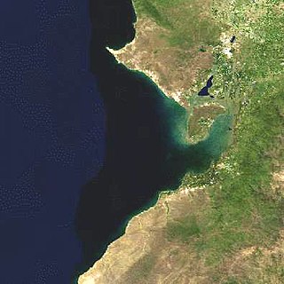
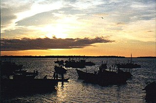
The Gulf of Guayaquil is a large body of water of the Pacific Ocean in western South America. Its northern limit is the city of Santa Elena, in Ecuador, and its southern limit is Cabo Blanco, in Peru.
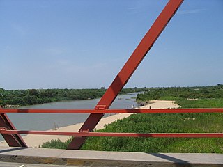
The Tumbes River, is a river in South America. The river's sources are located between Ecuadorian El Oro and Loja provinces. It is the border between El Oro and Loja, and afterwards the border between Loja and the Tumbes Region in Peru. At its confluence with the Cazaderos stream, it enters the northern coastal region of Peru called the Tumbes Region, and flows into the Pacific Ocean outside the Gulf of Guayaquil. The largest city on its banks is Tumbes, Peru.

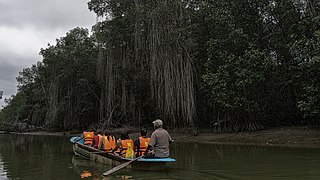
The Gulf of Guayaquil–Tumbes mangroves (NT1413) are an ecoregion located in the Gulf of Guayaquil in South America, in northern Peru and southern Ecuador. It has an area of 3,300 km².

Cerros de Amotape National Park is a protected area located in the regions of Piura and Tumbes in northern Peru.

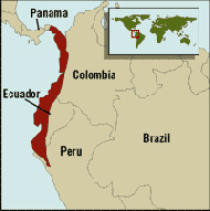
The Ecuadorian–Peruvian territorial dispute was a territorial dispute between Ecuador and Peru, which, until 1928, also included Colombia. The dispute had its origins on each country's interpretation of what Real Cedulas Spain used to precisely define its colonial territories in the Americas. After independence, all of Spain's colonial territories signed and agreed to proclaim their limits in the basis of the principle of uti possidetis juris, which regarded the Spanish borders of 1810 as the borders of the new republics. However, conflicting claims and disagreements between the newly formed countries eventually escalated to the point of armed conflicts on several occasions.
Tumbes National Reserve is a protected area established in 2006 and located in the region of Tumbes, Peru; near the border with Ecuador. It spans an area of 751 km2 (290 sq mi) and along with Cerros de Amotape National Park and El Angolo Game Preserve is part of the Noroeste Biosphere Reserve designated by UNESCO.
Cañari and Puruhá are two poorly-attested extinct languages of the Marañón River basin in Ecuador that are difficult to classify. Puruhá is scarcely attested, and Cañari is known primarily from placenames. Loukotka (1968) suggests they may have been related instead to Mochica (Yunga) in a family called Chimuan, but Adelaar (2004:397) thinks it is more likely that they were Barbacoan languages.
The 1953 Tumbes earthquake occurred on December 12 at near the border between Peru and Ecuador. The shock had a moment magnitude of 7.5, a maximum Mercalli Intensity of VIII (Severe), and occurred in the northwestern offshore area of Tumbes, Peru.

The Tumbes–Piura dry forests (NT0232) is an arid tropical ecoregion along the Pacific coasts of southern Ecuador and northern Peru. The ecoregion contains many endemic species of flora and birds adapted to the short wet season followed by a long dry season. Threats include extraction of wood for fuel or furniture, and capture of wild birds for sale.

Ecuador–Peru relations refers to the bilateral relations between Ecuador and Peru. Both nations are members of the Community of Latin American and Caribbean States, Organization of Ibero-American States, Organization of American States, and the United Nations.