
A bowl barrow is a type of burial mound or tumulus. A barrow is a mound of earth used to cover a tomb. The bowl barrow gets its name from its resemblance to an upturned bowl. Related terms include cairn circle, cairn ring, howe, kerb cairn, tump and rotunda grave.

Trecastle is a village in Powys, Wales, situated on the edge of the Brecon Beacons National Park (Welsh: Parc Cenedlaethol Bannau Brycheiniog) and in the community of Llywel. The village has a population of about 200.

Whittington is a small village near Worcester close to Junction 7 of the M5 motorway, bounded by the motorway and the B4084, in the District of Wychavon. The motorway cuts through the village, with the majority of the village lying on the western side.
Congrove Field and The Tumps is a is a 14.2 hectares biological Site of Special Scientific Interest (SSSI) on Lansdown Hill, north of Bath in Bath and North East Somerset, notified in 1991.

The Flying Liftboy is a 1998 Dutch family adventure film directed by Ben Sombogaart and written and produced by Burny Bos, based on the 1953 Dutch children's book Abeltje by Annie M. G. Schmidt.
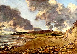
Jordan Hill is located near the coast close to the village of Preston, just to the east of Weymouth, Dorset, England. The hill leads down to Furzy Cliff on the coast to the south. Close by to the east is Bowleaze Cove. The hill figure of the Osmington White Horse can be seen from the hill to the north. There are also views across Bowleaze Cove from the hill and nearby public footpaths. The hill is a short detour from the South West Coastal Path National Trail.
Pegler is an English surname. Notable people with the surname include:

St Weonards is a village and civil parish in Herefordshire, England, located 10 miles (16 km) south of Hereford, 7 miles (11 km) west of Ross-on-Wye and 8 miles (13 km) north of Monmouth, on the A466 road. Within the parish and also on the A466 is the hamlet of Sandyway. St Weonards lies within the area known to the Saxons as Archenfield, previously the kingdom of Ergyng, adjoining the modern border with Wales. Ergyng was later reduced to a semi-autonomous cantref retaining Welsh language and customs until the early nineteenth century.
Konar Sandal is a village in Hoseynabad Rural District, Esmaili District, Jiroft County, Kerman Province, Iran. At the 2006 census, its population was 1,044, in 209 families.
Ab Sarduiyeh is a village in Rudbar Rural District, in the Central District of Rudbar-e Jonubi County, Kerman Province, Iran. At the 2006 census, its population was 992, in 197 families.

Whittington Tump or Crookbarrow Hill is a partly artificial mound in central Worcestershire, England. There is evidence of prehistoric activity at the site and may have been used as a religious site or burial mound. A Romano-British settlement was established nearby in the early 2nd century AD but was apparently abandoned by the 4th century. An Anglo-Saxon enclosure was established on Whittington Tump by the 7th century and during the mediaeval period it is thought to have been the site of a motte castle. Crookbarrow Manor was established at the foot of the hill by 1314 and the site, including the former motte, was given over to agricultural use. The site was listed as a scheduled monument in 1923 and is a landmark for motorists on the nearby M5 motorway.

Swanborough Tump is a mound of earth in Manningford parish, Wiltshire, England. It has been considered to be a bowl barrow dating from the Bronze Age and is listed as a scheduled monument.
This page is based on this
Wikipedia article Text is available under the
CC BY-SA 4.0 license; additional terms may apply.
Images, videos and audio are available under their respective licenses.