
The 2006 Pacific typhoon season was a below-average season that produced a total of 23 named storms, 15 typhoons, and six super typhoons. The season ran throughout 2006, though most tropical cyclones typically develop between May and October. The season's first named storm, Chanchu, developed on May 9, while the season's last named storm, Trami, dissipated on December 20.
The name Nina has been used for thirteen typhoons in the northwest Pacific Ocean, one tropical cyclone in the northeast Pacific Ocean, and one tropical cyclone in the southwest Pacific.
The name Isang has been used for sixteen tropical cyclones worldwide: fifteen times by the Philippine Atmospheric, Geophysical and Astronomical Services Administration (PAGASA) in the Western Pacific, and once by the Météo-France in the South-West Indian Ocean.
The name Helen or Hellen has been used for twenty tropical cyclones worldwide: sixteen in the Western Pacific Ocean, one in the North Indian Ocean, one in the South-West Indian Ocean, and two in the Australian region.
The name Lola has been used for seventeen tropical cyclones worldwide, fifteen in the Western Pacific Ocean, one in the South Pacific Ocean, and one in the South-West Indian Ocean.
The name Rose has been used for twelve tropical cyclones worldwide, including once in the Atlantic, ten in the northwest Pacific Ocean and once in the southwest Indian Ocean.
The name Auring has been used for sixteen tropical cyclones in the Philippines by PAGASA in the Western Pacific Ocean.
The name Goring has been used for 13 tropical cyclones in the Philippines by PAGASA in the Western Pacific.
The name Bising has been used for 14 tropical Cyclones in the Philippine Area of Responsibility by PAGASA in the Western Pacific.
The name Crising has been used for six tropical cyclones by PAGASA in the Western Pacific Ocean.

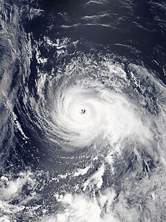
Typhoon Durian's meteorological history began with its origins as a tropical disturbance near Chuuk State on November 23, 2006, and lasted until its dissipation off the coast of Andhra Pradesh, India, on December 9. Durian formed as a tropical depression on November 25 near Chuuk State. Situated south of a ridge, the system tracked west-northwest over a region characterized by low wind shear and good upper-level divergence. Late on November 26, the depression intensified into a tropical storm and was named Durian. Steady strengthening took place over the following two days as the system approached the Philippines. After attaining typhoon status on November 29, Durian underwent a period of rapid intensification, culminating with it attaining peak winds of 195 km/h (120 mph) and a barometric pressure of 915 mbar. Durian brushed the southern coast of the Catanduanes at this intensity, where a record gust of 320 km/h (200 mph) was observed.

Typhoon Cimaron, known in the Philippines as Typhoon Paeng, was the most intense tropical cyclone to strike the Philippine island of Luzon since Typhoon Zeb in 1998. Originating from a tropical depression on October 25, Cimaron developed within an environment strongly favoring tropical cyclogenesis east of the Philippines. On October 28, the system underwent rapid intensification, culminating in attaining its peak strength with winds of 185 km/h (115 mph). Estimates from the Joint Typhoon Warning Center ranked the system as a Category 5-equivalent super typhoon with one-minute sustained winds of 260 km/h (160 mph), though this is argued to have underrepresented the typhoon's strength. The system moved ashore near Casiguran, Aurora in northern Luzon at peak strength. Crossing the island, Cimaron emerged over the South China Sea where conditions allowed for temporary reorganization. After becoming nearly stationary on November 1, the typhoon executed a tight anti-cyclonic loop and rapidly weakened. The storm degenerated into a tropical depression on November 4, before dissipating three days later off the coast of Vietnam.

Typhoon Chebi, known in the Philippines as Typhoon Queenie, was a powerful typhoon that impacted Luzon during November 2006. Chebi is the third typhoon since Typhoon Xangsane to hit the country destructively. The 30th tropical depression developed east of the Mariana Islands on October 31 as a weak disturbance. The system was dubbed into a tropical depression on November 8, until both the JMA and PAGASA upgraded it to a tropical storm on November 9. Chebi rapidly intensified to a Category 4 typhoon the next day and made landfall over northern Philippines on November 11. The system finally dissipated near Hong Kong and Vietnam on November 14.

Tropical Storm Cimaron, known in the Philippines as Tropical Storm Isang, was a weak tropical storm, with only a pressure of 1000 hPa and 45 mph. It formed and made landfall in the Philippines, especially Luzon, and China, as well as affecting Southern Taiwan during its nearby passage. Despite being weak, the storm caused extensive damage amounting to approximately $325 million in China, as well as 6 deaths in total, with 2 in the Philippines.
Typhoon Cimaron was a typhoon that caused minimal impacts in the Mariana Islands and Japan in August 2018. The twenty-third depression, twenty-first named storm, eleventh severe tropical storm, and seventh typhoon of the 2018 Pacific typhoon season, Cimaron developed from a tropical depression near the Marshall Islands on August 16. The depression soon became Tropical Storm Cimaron on August 18. Cimaron gradually intensified into a typhoon on August 21, and rapidly reached its peak intensity the next day. Cimaron then weakened before making two landfalls in Japan as a Category 1 typhoon on August 23. Cimaron continued to weaken until it became an extratropical cyclone and dissipated on August 24.
This page is based on this
Wikipedia article Text is available under the
CC BY-SA 4.0 license; additional terms may apply.
Images, videos and audio are available under their respective licenses.