
The 2005 Pacific typhoon season was the least active typhoon season since 2000, producing 23 named storms, of which 13 became typhoons. It was an event in the annual cycle of tropical cyclone formation, in which tropical cyclones form in the western Pacific Ocean. The season ran throughout 2005, though most tropical cyclones typically develop between May and October. The season's first named storm, Kulap, developed on January 13, while the season's last named storm, Bolaven, dissipated on November 20. The season's first typhoon, Haitang, reached typhoon status on July 13, and became the first super typhoon of the year three days later.
The name Winnie has been used for one tropical cyclone in the Northeastern Pacific, eleven tropical cyclones in the Northwestern Pacific Ocean and one in the Southwest Pacific Ocean.
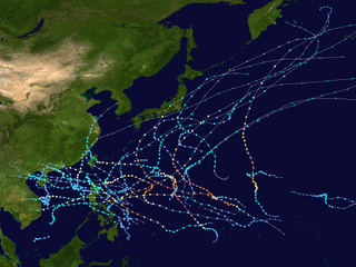
This timeline documents all of the events of the 2005 Pacific typhoon season, the period that tropical cyclones formed in the Western Pacific Ocean during 2005. Most of these tropical cyclones formed between May and November 2005. The scope of this article is limited to the Pacific Ocean, north of the equator between 100°E and the International Date Line. Tropical storms that form in the entire Western Pacific basin are assigned a name by the Japan Meteorological Agency (JMA). Tropical depressions that form in this basin are given a number with a "W" suffix by the United States' Joint Typhoon Warning Center (JTWC). In addition, the Philippine Atmospheric, Geophysical and Astronomical Services Administration (PAGASA) assigns names to tropical cyclones that enter or form in the Philippine area of responsibility. These names, however, are not in common use outside of the Philippines.

The 2008 Pacific typhoon season was a below average season which featured 22 named storms, eleven typhoons, and two super typhoons. The season had no official bounds; it ran year-round in 2008, but most tropical cyclones tend to form in the northwestern Pacific Ocean between May and November. These dates conventionally delimit the period of each year when most tropical cyclones form in the northwestern Pacific Ocean.
The 2009 Pacific typhoon season was a below average season that spawned only 22 named storms, 13 typhoons, and five super typhoons. It was also recognized as the deadliest season in the Philippines for decades. The first half of the season was very quiet whereas the second half of the season was extremely active. The season's first named storm, Kujira, developed on May 3 while the season's last named storm, Nida, dissipated on December 3.
The name Goring has been used for 13 tropical cyclones in the Philippines by PAGASA in the Western Pacific.
The name Falcon has been used for five tropical Cyclones in the Philippines by PAGASA in the Western Pacific Ocean.
The name Egay has been used in five tropical cyclones within the Philippines by the PAGASA in the Western Pacific.
The name Neneng has been used for thirteen tropical cyclones in the Philippines by PAGASA in the Western Pacific.
The name Basyang has been used in the Philippines by PAGASA in the Western Pacific.
The name Bising has been used for 14 tropical Cyclones in the Philippine Area of Responsibility by PAGASA in the Western Pacific.
The name Atring has been used to name nine tropical cyclones in the Philippine Area of Responsibility by PAGASA in the Western Pacific Ocean.

Typhoon Chan-hom, known in the Philippines as Typhoon Emong, was the sixth tropical depression and the second tropical storm to develop during the 2009 Pacific typhoon season. Chan-hom developed out of an area of convectional cloudiness associated with an area of disturbed weather which originated from the remnants of Tropical Depression Crising and formed southeast of Nha Trang, Vietnam on May 2. Moving towards the northeast, it slowly organized according to JTWC who issued a TCFA, and JMA classified Chan-hom as a minor tropical depression later that day. The next day, both JTWC and JMA upgraded the depression to a tropical storm and named it Chan-hom. On May 6, the storm intensified into a Category 1 typhoon, and on May 7, Chan-hom intensified into a Category 2 typhoon equivalent. However, Chan-hom weakened into a severe tropical storm after passing northern Luzon. On May 14, Chan-hom regenerated into a Tropical Depression, before dissipating late on May 15.
This timeline documents all of the events of the 2009 Pacific typhoon season which was the period that tropical cyclones formed in the Western Pacific Ocean during 2009, with most of the tropical cyclones forming between May and November. The scope of this article is limited to the Pacific Ocean, north of the equator between 100°E and the International Date Line. Tropical storms that form in the entire Western Pacific basin are assigned a name by the Japan Meteorological Agency. Tropical depressions that form in this basin are given a number with a "W" suffix by the United States' Joint Typhoon Warning Center. In addition, the Philippine Atmospheric, Geophysical and Astronomical Services Administration (PAGASA) assigns names to tropical cyclones that enter or form in the Philippine area of responsibility. These names, however, are not in common use outside of the Philippines.
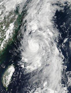
Severe Tropical Storm Nanmadol, known in the Philippines as Severe Tropical Storm Emong, was a tropical cyclone that impacted southern Japan during July 2017. Nanmadol developed over in the Philippine Sea as a tropical depression on July 1, and strengthened into the third named storm of the 2017 typhoon season on July 3. After gaining organization, the system rapidly developed and intensified into a severe tropical storm and reached its peak intensity with a 10-minute maximum sustained winds of 100 km/h (65 mph) and a minimum barometric pressure of 985 hPa (29.09 inHg). On July 4, Nanmadol turned eastwards and made landfall near Nagasaki, Kyushu, just before it transitioned into an extratropical cyclone.

The 2021 Pacific typhoon season was a below-average season that produced a total of 22 named storms, the least since 2011, 9 typhoons, and five super typhoons. The season's first named storm, Dujuan, developed on February 16, while the last named storm, Rai, dissipated on December 21. The season's first typhoon, Surigae, reached typhoon status on April 16. It became the first super typhoon of the year on the next day, also becoming the strongest tropical cyclone in 2021. Surigae was also the most powerful tropical cyclone on record in the Northern Hemisphere for the month of April. Typhoons In-fa and Rai are responsible for more than half of the total damage this season, adding up to a combined total of $2.017 billion.
The name Heling was used for nine tropical cyclones in the Philippines by PAGASA in the Western Pacific Ocean.
The name Bining was used for nine tropical cyclones by the Philippine Atmospheric, Geophysical and Astronomical Services Administration (PAGASA) in the Western Pacific Ocean.
This page is based on this
Wikipedia article Text is available under the
CC BY-SA 4.0 license; additional terms may apply.
Images, videos and audio are available under their respective licenses.