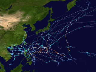
The 2005 Pacific typhoon season was the least active typhoon season since 2000, producing 23 named storms, of which 13 became typhoons. It was an event in the annual cycle of tropical cyclone formation, in which tropical cyclones form in the western Pacific Ocean. The season ran throughout 2005, though most tropical cyclones typically develop between May and October. The season's first named storm, Kulap, developed on January 13, while the season's last named storm, Bolaven, dissipated on November 20. The season's first typhoon, Haitang, reached typhoon status on July 13, and became the first super typhoon of the year three days later.

This timeline documents all of the events of the 2005 Pacific typhoon season, the period that tropical cyclones formed in the Western Pacific Ocean during 2005. Most of these tropical cyclones formed between May and November 2005. The scope of this article is limited to the Pacific Ocean, north of the equator between 100°E and the International Date Line. Tropical storms that form in the entire Western Pacific basin are assigned a name by the Japan Meteorological Agency (JMA). Tropical depressions that form in this basin are given a number with a "W" suffix by the United States' Joint Typhoon Warning Center (JTWC). In addition, the Philippine Atmospheric, Geophysical and Astronomical Services Administration (PAGASA) assigns names to tropical cyclones that enter or form in the Philippine area of responsibility. These names, however, are not in common use outside of the Philippines.

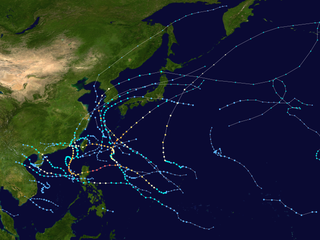
The 1998 Pacific typhoon season was at the time the least active Pacific typhoon season on record, until the record was surpassed 12 years later, spawning 16 tropical storms and 8 typhoons. The scope of this article is limited to the Pacific Ocean, north of the equator and west of the international date line. Storms that form east of the date line and north of the equator are called hurricanes; see 1998 Pacific hurricane season. Tropical Storms formed in the entire west Pacific basin were assigned a name by the Joint Typhoon Warning Center. Tropical depressions in this basin have the "W" suffix added to their number. Tropical depressions that enter or form in the Philippine area of responsibility are assigned a name by the Philippine Atmospheric, Geophysical and Astronomical Services Administration or PAGASA. This can often result in the same storm having two names.
The name Isang has been used for sixteen tropical cyclones worldwide: fifteen times by the Philippine Atmospheric, Geophysical and Astronomical Services Administration (PAGASA) and its predecessor, the Philippine Weather Bureau in the Western Pacific, and once by the Météo-France in the South-West Indian Ocean.

The 2008 Pacific typhoon season was a below average season which featured 22 named storms, eleven typhoons, and two super typhoons. The season had no official bounds; it ran year-round in 2008, but most tropical cyclones tend to form in the northwestern Pacific Ocean between May and November. These dates conventionally delimit the period of each year when most tropical cyclones form in the northwestern Pacific Ocean.

Typhoon Fung-wong, known in the Philippines as Typhoon Igme, was a deadly typhoon in the 2008 Pacific typhoon season which made landfall on Taiwan and China. Typhoon Fung-wong reached peak intensity of a Category 2 typhoon on the Saffir-Simpson Hurricane Scale by the Joint Typhoon Warning Center with peak winds of 95 knots (176 km/h). Damage was extensive in Taiwan, hitting little more than a week later than Typhoon Kalmaegi, but a specific cost is unknown, though later estimated at 541 million.

The 2009 Pacific typhoon season was a below average season that spawned only 22 named storms, 13 typhoons, and five super typhoons. It was also recognized as the deadliest season in the Philippines for decades. The first half of the season was very quiet whereas the second half of the season was extremely active. The season's first named storm, Kujira, developed on May 3 while the season's last named storm, Nida, dissipated on December 3.

The 2010 Pacific typhoon season, with 14 named storms is the least active Pacific typhoon season on record. Seven of them strengthened into typhoons while one reached super typhoon intensity. The Pacific typhoon season during 2010 was in fact less active than the 2010 Atlantic hurricane season, with only two other occurrences of that happening, 2005 and 2020. In the same year, the Pacific hurricane season broke the same record being the least active season on record. During the season, no storms made landfall in mainland Japan, only the second such occurrence since 1988. Also, all of the 14 named storms developed west of 150°E.
The name Goring has been used for 13 tropical cyclones in the Philippines by PAGASA and its predecessor, the Philippine Weather Bureau, in the Western Pacific.
The name Egay has been used in five tropical cyclones within the Philippines by the PAGASA in the Western Pacific.
The name Bising has been used for 14 tropical cyclones in the Philippine Area of Responsibility by PAGASA and its predecessor, the Philippine Weather Bureau, in the Western Pacific.

The 2017 Pacific typhoon season was a below-average season in terms of accumulated cyclone energy and the number of typhoons and super typhoons, and the first since the 1977 season to not produce a Category 5-equivalent typhoon on the Saffir–Simpson scale. The season produced a total of 27 named storms, 11 typhoons, and only two super typhoons, making it an average season in terms of storm numbers. It was an event in the annual cycle of tropical cyclone formation, in which tropical cyclones form in the western Pacific Ocean. The season runs throughout 2017, though most tropical cyclones typically develop between May and October. The season's first named storm, Muifa, developed on April 25, while the season's last named storm, Tembin, dissipated on December 26. This season also featured the latest occurrence of the first typhoon of the year since 1998, with Noru reaching this intensity on July 23.

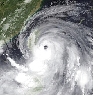
Typhoon Soulik, known in the Philippines as Typhoon Huaning, was a powerful tropical cyclone that caused widespread damage in Taiwan and East China in July 2013. The storm originated from an upper-level cold-core low well to the northeast of Guam on July 6. Gaining tropical characteristics, the system soon developed a surface low and became a tropical depression early on July 7. Tracking generally westward, a motion it would retain for its entire existence, the depression underwent a period of rapid intensification starting on July 8 that culminated in Soulik attaining its peak strength early on July 10. At that time, the system had sustained winds estimated at 185 km/h (115 mph) and barometric pressure of 925 mbar. Thereafter, an eyewall replacement cycle and cooler waters weakened the system. Though it passed over the warm waters of the Kuroshio Current the following day, dry air soon impinged upon the typhoon. Soulik later made landfall late on July 12 in northern Taiwan before degrading to a tropical storm. Briefly emerging over the Taiwan Strait, the storm moved onshore for a second time in Fujian on July 13. The system was last noted as a tropical depression early on July 14.
The name Gading was used for nine tropical cyclones in the Philippines by PAGASA in the Western Pacific Ocean.
The name Luding was used for ten tropical cyclones by the Philippine Atmospheric, Geophysical and Astronomical Services Administration (PAGASA) and its predecessor, the Philippine Weather Bureau, in the Western Pacific Ocean.
The name Lusing was used for ten tropical cyclones by the Philippine Atmospheric, Geophysical and Astronomical Services Administration (PAGASA) and its predecessor, the Philippine Weather Bureau, in the Western Pacific Ocean.
This page is based on this
Wikipedia article Text is available under the
CC BY-SA 4.0 license; additional terms may apply.
Images, videos and audio are available under their respective licenses.


