The name Hanna or Hannah has been used for eleven tropical cyclones worldwide: five in the Atlantic Ocean and six in the Western Pacific Ocean. Hanna has also been used for one extratropical European windstorm.
The name Karen has been used for seventeen tropical cyclones worldwide: six in the Atlantic Ocean, nine in the Western Pacific Ocean, one in the South-West Indian Ocean, and one in the Australian region.
The name Betty has been used for a total of twenty tropical cyclones worldwide: one in the Atlantic Ocean, two in the South Pacific Ocean, one in the South-West Indian Ocean, and sixteen in the Western Pacific Ocean.

The 2004 Pacific typhoon season was an extremely active season that featured the second-highest ACE ever recorded in a single season, second only to 1997, which featured 29 named storms, nineteen typhoons, and six super typhoons. It was an event in the annual cycle of tropical cyclone formation, in which tropical cyclones form in the western Pacific Ocean. The season ran throughout 2004, though most tropical cyclones typically develop between May and October. The season's first named storm and also the first typhoon, Sudal, developed on April 4, later was reached typhoon status two days later, and became the first super typhoon of the year three days later. The season's last named storm, Noru, dissipated on December 21.
The name Nina has been used for thirteen typhoons in the northwest Pacific Ocean, one tropical cyclone in the northeast Pacific Ocean, and one tropical cyclone in the southwest Pacific.
The name Alice has been used for eighteen tropical cyclones worldwide: four in the Atlantic Ocean, ten in the Western Pacific Ocean, one in the South-West Indian Ocean, and three in the Australian region.

The 1973 Pacific typhoon season has no official bounds; it ran year-round in 1973, but most tropical cyclones tend to form in the northwestern Pacific Ocean between June and December. These dates conventionally delimit the period of each year when most tropical cyclones form in the northwestern Pacific Ocean.
The name Helen or Hellen has been used for twenty tropical cyclones worldwide: sixteen in the Western Pacific Ocean, one in the North Indian Ocean, one in the South-West Indian Ocean, and two in the Australian region.
The name Dodong has been used in the Philippines by PAGASA in the Western Pacific.
The name Basyang has been used in the Philippines by PAGASA in the Western Pacific.
The name Nida has been used for three tropical cyclones in the western north Pacific Ocean. The name was contributed by Thailand and means a name of woman.

The 2016 Pacific typhoon season is considered to have been the fourth-latest start for a Pacific typhoon season since reliable records began. It was an average season, with a total of 26 named storms, 13 typhoons, and six super typhoons. The season ran throughout 2016, though typically most tropical cyclones develop between May and October. The season's first named storm, Nepartak, developed on July 3, while the season's last named storm, Nock-ten, dissipated on December 28.

Typhoon Sarika, known in the Philippines as Typhoon Karen, was a powerful tropical cyclone which affected the Philippines, South China, and Vietnam in mid-October 2016. The twenty-first named storm and the tenth typhoon of the annual Pacific typhoon season, Sarika developed from a tropical disturbance east of the Philippines on October 13. The system steadily strengthened as it traveled westwards, becoming a tropical storm later that day and then a typhoon on October 15. Rapid intensification commenced as Sarika turned to the west-northwest towards Luzon, reaching its peak intensity just before making landfall in Aurora early on October 16. Sarika weakened significantly as it crossed land, emerging over the South China Sea as a minimal typhoon, then weakening further to a severe tropical storm on October 17. Sarika maintained its strength for the rest of the day and made landfall in Hainan province in China on October 18. Turning to the northwest, Sarika weakened quickly as it emerged into the Gulf of Tonkin, before moving onshore once again in Guangxi province on October 19. The system dissipated shortly after.

Typhoon Nock-ten, known in the Philippines as Typhoon Nina, was the strongest Christmas Day tropical cyclone worldwide in terms of 1-minute sustained winds. Forming as a tropical depression southeast of Yap and strengthening into the twenty-sixth tropical storm of the annual typhoon season on December 21, 2016, Nock-ten intensified into the thirteenth typhoon of the season on December 23. Soon afterwards, the system underwent explosive intensification and became a Category 5-equivalent super typhoon early on December 25. Nock-ten weakened shortly afterwards before making eight landfalls over the Philippines. The typhoon weakened rapidly due to the landfalls as it entered the South China Sea on December 26, turned southwest, and ultimately dissipated on December 28 due to the winter monsoon.
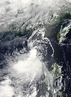
Tropical Storm Sarika, known in the Philippines as Tropical Storm Dodong, was a weak but costly tropical storm that affected Philippines and the East China in early-June 2011. The sixth tropical depression and the third named storm of the 2011 Pacific typhoon season, Sarika formed from an area of low pressure near Cebu City. As it traversed the Verde Island Passage on June 8, both the JTWC and the JMA started issuing advisories on the system, with the former issuing a TCFA on the system later that day. The next day, the PAGASA upgraded the low-pressure area to a tropical depression, naming it Dodong. Moving to the north, the system struggled to intensify due to strong wind shear and was downgraded by the JTWC to a tropical depression; however, the JMA kept the system as a minimal tropical storm until it made landfall near Shantou on June 11. It dissipated soon thereafter.
The name Luding was used for ten tropical cyclones by the Philippine Atmospheric, Geophysical and Astronomical Services Administration (PAGASA) and its predecessor, the Philippine Weather Bureau, in the Western Pacific Ocean.
This page is based on this
Wikipedia article Text is available under the
CC BY-SA 4.0 license; additional terms may apply.
Images, videos and audio are available under their respective licenses.