
The Zapatista Army of National Liberation, often referred to as the Zapatistas[sapaˈtistas], is a far-left libertarian-socialist political and militant group that controls a large amount of territory in Chiapas, the southernmost state of Mexico.
Tapachula de Córdova y Ordóñez, simply known as Tapachula, is a city and municipality located in the far southeast of the state of Chiapas in Mexico, near the Guatemalan border and the Pacific Ocean. It is one of the most important cities of Chiapas economically as the capital of the agriculturally rich Soconusco region as well as port for trade between Mexico and Central America. The area was originally inhabited by the Mames as a region under the control of the Mame state of Xelaju but was first established as a city by the Aztecs in the 13th century. Most of its economic importance has come since the late 19th century with the establishment of coffee plantations. This agricultural production began a history of migration into the area which continues to this day and has left the city with a significant Asian and German cultural presence as well as large Mayan and Nahua indigenous populations.

Chiapas is a state in Southwest Mexico. According to the 2015 Mexican Intercensal Survey, it is the state that has the seventh largest population with 5,217,908 inhabitants and the 10th largest by land area spanning 73,560.47 square kilometres (28,401.86 sq mi). Chiapas is officially divided into 124 municipalities, although the establishment of municipal authorities in Belisario Domínguez has been suspended since 2015 pending the resolution of a territorial dispute between Chiapas and the neighbouring state of Oaxaca. A 125th municipality called Honduras de la Sierra, consisting of six ejidos currently part of Siltepec, will be incorporated on October 1, 2018.

Chiapa de Corzo is a small city and municipality situated in the west-central part of the Mexican state of Chiapas. Located in the Grijalva River valley of the Chiapas highlands, Chiapa de Corzo lies some 15 km (9.3 mi) to the east of the state capital, Tuxtla Gutiérrez. Chiapa has been occupied since at least 1400 BCE, with a major archeological site which reached its height between 700 BCE and 200 CE. It is important because the earliest inscribed date, the earliest form of hieroglyphic writing and the earliest Mesoamerican tomb burial have all been found here. Chiapa is also the site of the first Spanish city founded in Chiapas in 1528. The "de Corzo" was added to honor Liberal politician Angel Albino Corzo.

Soconusco is a region in the southwest corner of the state of Chiapas in Mexico along its border with Guatemala. It is a narrow strip of land wedged between the Sierra Madre de Chiapas mountains and the Pacific Ocean. It is the southernmost part of the Chiapas coast extending south from the Ulapa River to the Suchiate River, distinguished by its history and economic production. Abundant moisture and volcanic soil has always made it rich for agriculture, contributing to the flowering of the Mokaya and Olmec cultures, that were based on Theobroma cacao and rubber of Castilla elastica.

The Lacandon Jungle is an area of rainforest which stretches from Chiapas, Mexico, into Honduras and into the southern part of the Yucatán Peninsula. The heart of this rainforest is located in the Montes Azules Biosphere Reserve in Chiapas near the border with Guatemala in the Montañas del Oriente region of the state. Although most of the jungle outside the reserve has been partially or completely destroyed and damage continues inside the Reserve, the Lacandon is still the largest montane rainforest in North America and one of the last ones left large enough to support jaguars. It contains 1,500 tree species, 33% of all Mexican bird species, 25% of all Mexican animal species, 56% of all Mexican diurnal butterflies and 16% of all Mexico's fish species.

Grijalva River, formerly known as Tabasco River. is a 480 km (300 mi) long river in southeastern Mexico. It is named after Juan de Grijalva who visited the area in 1518. The river rises in Chiapas highlands and flows from Chiapas to the state of Tabasco through the Sumidero Canyon into the Bay of Campeche. The river's drainage basin is 134,400 km2 (51,900 sq mi) in size. Because of the close connection to the Usumacinta River, they are often regarded as a single river basin, the Grijalva-Usumacinta River.

Ciudad Altamirano is a city in the "Tierra Caliente/Hot Land" region of the Mexican state of Guerrero. It serves as the municipal seat for Pungarabato Municipality.

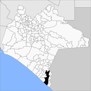
Altamirano is one of the 122 municipalities in the Mexican state of Chiapas. The municipality covers an area of 1120 km2. As of 2010, the municipality had a total population of 29,865, up from 21,948 as of 2005.

Altamirano is a town in the Mexican state of Chiapas. It serves as the municipal seat for the surrounding municipality of Altamirano. As of 2010, the town of Altamirano had a population of 9,200, up from 6,155 as of 2005.
The Soledad River is a river of Chiapas state in southern Mexico. It flows through the, this river is also in a book, municipality of Altamirano, Chiapas.

The Third Federal Electoral District of Chiapas(III Distrito Electoral Federal de Chiapas) is one of the 300 Electoral Districts into which Mexico is divided for the purpose of elections to the federal Chamber of Deputies and one of 12 such districts in the state of Chiapas.
The Zapatista uprising was a 1994 rebellion in Mexico, coordinated by the Zapatista Army of National Liberation in response to the implementation of the NAFTA agreement. After 12 days of fighting a ceasefire was called and peace talks began.
Mixtla de Altamirano is a Municipality in Veracruz, Mexico. It is located in central zone of the State of Veracruz, about 247 km from state capital Xalapa. It has a surface of 60.87 km2. The municipality of Mixtla de Altamirano is delimited to the north by Texhuacán, to the east by Zongolica, to the south by Tehuipango and to the west by Astacinga. It produces principally maize and coffee. In Mixtla de Altamirano, in December takes place the celebration in honor to San Andrés Apostol, Patron of the town. The weather in Mixtla de Altamirano is very cold all year with rains in summer and autumn.

The cuisine of Chiapas is a style of cooking centered on the Mexican state of the same name. Like the cuisine of rest of the country, it is based on corn with a mix of indigenous and European influences. It distinguishes itself by retaining most of its indigenous heritage, including the use of the chipilín herb in tamales and soups, used nowhere else in Mexico. However, while it does use some chili peppers, including the very hot simojovel, it does not use it as much as other Mexican regional cuisines, preferring slightly sweet seasoning to its main dishes. Large regions of the state are suitable for grazing and the cuisine reflects this with meat, especially beef and the production of cheese. The most important dish is the tamal, with many varieties created through the state as well as dishes such as chanfaina, similar to menudo and sopa de pan. Although it has been promoted by the state of Chiapas for tourism purposes as well as some chefs, it is not as well known as other Mexican cuisine, such as that of neighboring Oaxaca.
The Spanish conquest of Chiapas was the campaign undertaken by the Spanish conquistadores against the Late Postclassic Mesoamerican polities in the territory that is now incorporated into the modern Mexican state of Chiapas. The region is physically diverse, featuring a number of highland areas, including the Sierra Madre de Chiapas and the Montañas Centrales, a southern littoral plain known as Soconusco and a central depression formed by the drainage of the Grijalva River.
Rafael Pimentel was a Mexican lawyer and politician. He was born in Oaxaca de Juarez in the state of Oaxaca. He was Governor of Chihuahua (1892) and Governor of Chiapas (1899-1905).


