Hvalsø is a town and a former municipality in Region Sjælland on the island of Zealand (Sjælland) in east Denmark. The former municipality covered an area of 72 km2, and had a total population of 7,856 (2005). Its last mayor was Virginia Holst, a member of the Venstre political party. She was the first foreign national becoming mayor in a Danish municipality.
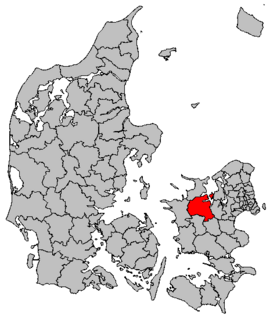
Skovbo is a former municipality in Roskilde County on the island of Zealand (Sjælland) in east Denmark. It covered an area of 132 km², and had a total population of 14,873 (2005). Its last mayor was Ole Hansen, a member of the Venstre political party.

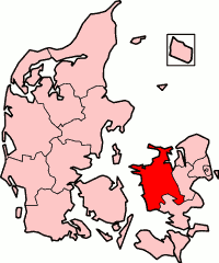
Vallø was a municipality in the former Roskilde County on the east coast of the island of Zealand (Sjælland) in East Denmark. The municipality covered an area of 84 km², and had a total population of 10,337 (2005). Its last mayor was Poul Arne Nielsen, a member of the Venstre political party.

Langebæk is a town with a population of 242 and a former municipality in Region Sjælland on the southeastern tip of the island of Zealand (Sjælland) in south Denmark. The municipality included the islands of Langø, Tærø and Lilleø, and it covered an area of 101 km2. It had a total population of 6,332 in 2005. Its last mayor was Henrik Holmer, a member of the Social Democrats (Socialdemokraterne) political party.

Rødby is a town and a former municipality on the island of Lolland in Denmark. The former Rødby municipality covered an area of 120 km², and had a total population of 6,590 (2005). Its last mayor was Hans Ole Sørensen, a member of the Venstre political party.
Rønnede was a municipality in the former Storstrøm County in south Denmark. The municipality covered an area of 125 km², and had a total population of 7,289 (2005). Its last mayor was Kurt Rosner, a member of the Venstre political party.
Until January 1, 2007 Suså was a municipality in the former Storstrøm County in the southern part of the island of Zealand (Sjælland) in south Denmark. The municipality covered an area of 145 km², and had a total population of 8,529 (2005). Its last mayor was Poul Erik Sørensen, a member of the Social Democrats (Socialdemokraterne) political party. The main town and the site of its municipal council was the town of Glumsø.
Until 1 January 2007, Haslev municipality was a Danish, kommune) in West Zealand County on the island of Zealand (Sjælland) in Denmark. The municipality covered an area of 133 km², and had a total population of 14,781 (2005). Its last mayor was Henrik Christensen, a member of the Venstre political party. The main town and site of its municipal council was the town of Haslev.
Until 1 January 2007 Hvidebæk was a municipality in West Zealand County on the west coast of the island of Zealand (Sjælland) in Denmark. The municipality covered an area of 98,26 km², and had a total population of 5,492 (2005). Its last mayor was Henning Fougt, a member of the Venstre political party. The main town and the site of its municipal council was the town of Jerslev Sjælland.
Høng is a town with a population of 4,311 and a former municipality in Region Sjælland near the west coast of the island of Zealand (Sjælland) in Denmark. The municipality covered an area of 145 km², and had a total population of 8,411 (2005). Its last mayor was Ingver Jensen.
Until January 1, 2007 Hashøj municipality was a municipality in West Zealand County near the west coast of the island of Zealand (Sjælland) in Denmark. The municipality covered an area of 131 km², and had a total population of 6,632 (2005). Its last mayor was Troels Christensen, a member of the Venstre political party. The main town and the site of its municipal council was the town of Dalmose. The municipality was named after the hill Hashøjen near the town of Slots Bjergby.
Until January 1, 2007, Dianalund municipality was a municipality in West Zealand County on the island of Zealand (Sjælland) in east Denmark. The municipality covered an area of 67 km², and had a total population of 7,406 (2005). Its last mayor was Per Hovmand, a member of the Conservative People's Party political party. The main town and the site of its municipal council was the town of Dianalund.
Until 1 January 2007 Stenlille municipality was a municipality in the former West Zealand County on the island of Zealand (Sjælland) in east Denmark. The municipality covered an area of 94 km², and had a total population of 5,544 (2005). Its last mayor was Vagn Guldborg, a member of the Venstre political party. The main town and the site of its municipal council was the town of Stenlille.
Fuglebjerg, with a population of 2,181, is a town in Næstved municipality on Zealand in Region Sjælland in Denmark.
Until January 1, 2007 Jernløse municipality was a municipality in northeastern West Zealand County on the island of Zealand (Sjælland) in Denmark. The municipality covered an area of 103 km², and had a population of 5,943 (2005). Its last mayor was Annica Granstrøm representing Venstre, Denmark's Liberal Party. The site of the municipal council was the town of Nørre Jernløse. Regstrup is the biggest town in the municipal.
Until January 1, 2007 Svinninge municipality was a municipality in the former West Zealand County on the island of Zealand (Sjælland) in eastern Denmark. The municipality covered an area of 86 km², and had a population of 6,588 (2005). Its last mayor was Søren Christensen, representing Venstre, Denmark's Liberal Party. The site of the municipal council was the town of Svinninge.
Until 1 January 2007 Nykøbing-Rørvig municipality was a municipality in the former West Zealand County on the northwest coast of the island of Zealand (Sjælland) in Denmark, at the mouth of the Isefjord. The municipality covered an area of 40 km², and had a total population of 7,610 (2005). Its last mayor was Vagn Ytte Larsen, a member of the Social Democrats (Socialdemokraterne) political party. The site of its municipal council is the town of Nykøbing Sjælland.
Trundholm municipality was a municipality in West Zealand County on the northwest coast of the island of Zealand (Sjælland) in Denmark, in a region or landscape known as Odsherred. The municipality covered an area of 163 km², and had a total population of 11,309 (2005). Its last mayor was Hans Møller Olsen, a member of the Venstre political party.
Until January 1, 2007 Tornved municipality was a municipality in the former West Zealand County on the island of Zealand (Sjælland) in Denmark. The municipality covered an area of 105 km², and had a total population of 9,135 (2005). Its last mayor was Jens Stenbæk, a member of the Venstre political party. The main town and the site of its municipal council was the town of Jyderup.