Washington commonly refers to:

Washington Union Station is a major train station, transportation hub, and leisure destination in Washington, D.C. Opened in 1907, it is Amtrak's headquarters and the railroad's second-busiest station with annual ridership of just under 5 million and the ninth-busiest in overall passengers served in the United States. The station is the southern terminus of the Northeast Corridor, an electrified rail line extending north through major cities including Baltimore, Philadelphia, New York City, and Boston and the busiest passenger rail line in the nation.

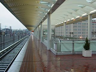
NoMa–Gallaudet U is an elevated, island platformed station on the Washington Metropolitan Area Transit Authority's (WMATA) Metro system. It is located on the same embankment as the Amtrak tracks into Union Station. It serves the Red Line, and is situated between Union Station and Rhode Island Avenue–Brentwood stations. NoMa–Gallaudet U is located near the intersection of New York Avenue and Florida Avenue in Northeast Washington, D.C. The station is within the NoMa neighborhood, which is both residential and commercial, and the station itself is in a commercial district on Florida Avenue. The station opened under the name New York Ave–Florida Ave–Gallaudet U on November 20, 2004, as both the system's first infill station and as the first to be built with a mix of public and private funds. Additionally, a portion of the Metropolitan Branch Trail was completed as part of its construction.

Rhode Island Avenue is a Washington Metro station in Washington, D.C. on the Red Line. The station is located in the Brentwood neighborhood of Northeast, on an elevated platform crossing Rhode Island Avenue NE

McPherson Square is a side-platformed Washington Metro station in Downtown Washington, D.C., United States. The station is operated by the Washington Metropolitan Area Transit Authority (WMATA). Providing service for the Blue, Silver, and Orange Lines, the station is located between McPherson Square and Franklin Square, with two entrances on I Street at Vermont Avenue and 14th Street NW. This is the main station to access the White House, and the Vermont Avenue exit is directly underneath the Department of Veterans Affairs building.
14th Street may refer to several locations in the United States:

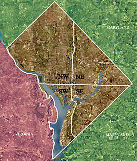
Northeast is the northeastern quadrant of Washington, D.C., the capital of the United States. It encompasses the area located north of East Capitol Street and east of North Capitol Street.
Massachusetts Avenue may refer to:

Takoma, Washington, D.C., is a neighborhood in Washington, D.C.. It is located in Advisory Neighborhood Commission 4B, in the District's Fourth Ward, within the northwest quadrant. It borders the city of Takoma Park, Maryland.

Massachusetts Avenue is a major diagonal transverse road in Washington, D.C., and the Massachusetts Avenue Historic District is a historic district that includes part of it.

Connecticut Avenue is a major thoroughfare in the Northwest quadrant of Washington, D.C., and suburban Montgomery County, Maryland. It is one of the diagonal avenues radiating from the White House, and the segment south of Florida Avenue was one of the original streets in Pierre (Peter) Charles L'Enfant's plan for Washington.

Wisconsin Avenue is a major thoroughfare in Washington, D.C., and its Maryland suburbs. The southern terminus begins in Georgetown just north of the Potomac River, at an intersection with K Street under the elevated Whitehurst Freeway. The section of Wisconsin Avenue in Georgetown was called High Street before the street names in Georgetown were changed in 1895 to conform to those of the L'Enfant plan for the federal city.

Rhode Island Avenue is a diagonal avenue in the Northwest and Northeast quadrants of Washington, D.C. and the capital's inner suburbs in Prince George's County, Maryland. Paralleling New York Avenue, Rhode Island Avenue was one of the original streets in Pierre L'Enfant's plan for the capital. It became a major commuter route, carrying U.S. Route 1 traffic into the city from Prince George's County.
New York Avenue may refer to:

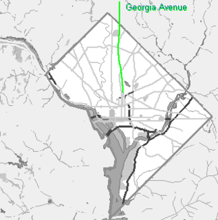
Georgia Avenue is a major north-south artery in Northwest Washington, D.C. and Montgomery County, Maryland. Within the District of Columbia and a short distance in Silver Spring, Maryland, Georgia Avenue is also U.S. Route 29. Both Howard University and Walter Reed Army Medical Center are located on Georgia Avenue.

David Magie Childs is an American architect and chairman emeritus of the architectural firm Skidmore, Owings & Merrill. He is best known for being the architect of the new One World Trade Center in New York City.

Downtown is a neighborhood of Washington, D.C., as well as a colloquial name for the central business district in the northwest quadrant of the city. Historically, the Downtown has been defined as an area east of 16th Street NW, north of the National Mall/US Capitol complex, and south of Massachusetts Avenue, including the Penn Quarter. However, the city says that most residents, workers, and visitors think of Downtown in a broader sense—including areas as far north as Dupont Circle, the Golden Triangle, as far west as Foggy Bottom, and as far east as Capitol Hill. A small portion of this area is known as the Downtown Historic District and was listed on the NRHP in 2001.
Washington Avenue may refer to:
Eight Street station or 8th Street station may refer to:


