
Oxfordshire is a landlocked county in South East England. The ceremonial county borders Warwickshire to the north-west, Northamptonshire to the north-east, Buckinghamshire to the east, Berkshire to the south, Wiltshire to the south-west and Gloucestershire to the west.

The Uffington White Horse is a prehistoric hill figure, 110 m (360 ft) long, formed from deep trenches filled with crushed white chalk. The figure is situated on the upper slopes of White Horse Hill in the English civil parish of Uffington, some 10 mi (16 km) east of Swindon, 8 km (5 mi) south of the town of Faringdon and a similar distance west of the town of Wantage; or 2.5 km (1.6 mi) south of Uffington. The hill forms a part of the scarp of the Berkshire Downs and overlooks the Vale of White Horse to the north. The best views of the figure are obtained from the air, or from directly across the Vale, particularly around the villages of Great Coxwell, Longcot and Fernham. The site is owned and managed by the National Trust and is a scheduled monument. The Guardian stated in 2003 that "for more than 3,000 years, the Uffington White Horse has been jealously guarded as a masterpiece of minimalist art." The Uffington Horse is by far the oldest of the white horse figures in Britain and is of an entirely different design from the others inspired by it.

Uffington Castle is an early Iron Age univallate hillfort in Oxfordshire, England. It covers about 32,000 square metres and is surrounded by two earth banks separated by a ditch with an entrance in the western end. A second entrance in the eastern end was apparently blocked up a few centuries after it was built. The original defensive ditch was V-shaped with a small box rampart in front and a larger one behind it. Timber posts stood on the ramparts. Later the ditch was deepened and the extra material dumped on top of the ramparts to increase their size. A parapet wall of sarsen stones lined the top of the innermost rampart. It is very close to the Uffington White Horse on White Horse Hill.
The Vale of White Horse is a local government district of Oxfordshire in England. It was historically a north-west projection of Berkshire. The area is commonly referred to as the 'Vale of the White Horse' and is crossed by the Ridgeway National Trail in its far south, across the North Wessex Downs AONB at the junction of four counties. The northern boundary is defined by the River Thames. The name refers to Uffington White Horse, a prehistoric hill figure.

The Berkshire Downs are a range of chalk downland hills in southern England, part of the North Wessex Downs Area of Outstanding Natural Beauty. The Berkshire Downs are wholly within the traditional county of Berkshire, although split between the current ceremonial counties of Berkshire and Oxfordshire. The western parts of the downs are also known as the Lambourn Downs.
Claydon is a place name in:
Uffington is a village and civil parish in Oxfordshire, about 4 miles (6.4 km) south of Faringdon and 6 miles (10 km) west of Wantage.

Didcot Parkway is a railway station serving the town of Didcot in Oxfordshire, England. The station was opened as Didcot on 12 June 1844 and renamed Didcot Parkway on 29 July 1985 by British Rail to reflect its role as a park and ride railhead. It is 53 miles 10 chains (85.5 km) down the line from London Paddington and is situated between Cholsey to the east and Swindon to the west.

Whitehorse Hill is a hill in the Berkshire Downs in Oxfordshire, England, west of Wantage. At 261 metres (856 ft), it is the highest point in Oxfordshire. Uffington Castle lies on the summit of the hill, and the Uffington White Horse is on the hill's northern slope. The hill and an adjacent area below, including Dragon Hill and The Manger, make up a 98.9-hectare (244-acre) biological and geological Site of Special Scientific Interest.

Baulking or Balking is a village and civil parish about 3+1⁄2 miles (5.6 km) southeast of Faringdon in the Vale of White Horse district of Oxfordshire. It was part of Berkshire until the 1974 Boundary Changes transferred it to Oxfordshire.

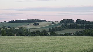
Longcot is a village and civil parish in the Vale of White Horse District. It was part of Berkshire until the 1974 boundary changes transferred it to Oxfordshire. The village is about 3 miles (5 km) south of Faringdon and about 2.5 miles (4 km) northeast of Shrivenham. The A420 road between Swindon and Oxford passes through the parish 1 mile (1.6 km) northwest of the village. The 2011 Census recorded the parish's population as 617.

Uffington and Barnack was a railway station in the Soke of Peterborough serving the villages of Uffington, Barnack and Bainton.
Uffington railway station is a former station on the Great Western Main Line. The station was located north-east of the village of Uffington, on the east side of the road between Fernham and Baulking.
The Faringdon branch was a 3+1⁄2-mile-long branch line from Uffington Station to Faringdon in the Vale of White Horse, in Oxfordshire.

Faringdon railway station is a closed stone and brick built railway station that served the market town of Faringdon, in Oxfordshire, England and was on the Faringdon branch line.

Fernham is a village and civil parish about 2 miles (3 km) south of Faringdon in the Vale of White Horse, Oxfordshire, England. Fernham was historically part of the parish of Shrivenham. It was within Berkshire until the 1974 local authority boundary changes transferred the Vale of White Horse to Oxfordshire.

Woolstone is a village and civil parish about 4+1⁄2 miles (7 km) south of Faringdon in the Vale of White Horse. Woolstone was part of Berkshire until the 1974 boundary changes transferred it to Oxfordshire. The 2011 Census recorded the parish population as 210.

Tom Brown's School Museum is a local museum in the village of Uffington, Oxfordshire, England. It was opened in 1984.
This page is based on this
Wikipedia article Text is available under the
CC BY-SA 4.0 license; additional terms may apply.
Images, videos and audio are available under their respective licenses.