
Victoria Island is a large island in the Canadian Arctic Archipelago that straddles the boundary between Nunavut and the Northwest Territories of Canada. It is the eighth largest island in the world, and at 217,291 km2 (83,897 sq mi) in area, it is Canada's second largest island. It is nearly double the size of Newfoundland (111,390 km2 [43,008 sq mi]), and is slightly larger than the island of Great Britain (209,331 km2 [80,823 sq mi]) but smaller than Honshu (225,800 km2 [87,182 sq mi]). It contains the world's largest island within an island within an island. The western third of the island belongs to the Inuvik Region in the Northwest Territories; the remainder is part of Nunavut's Kitikmeot Region.

The Arctic Archipelago, also known as the Canadian Arctic Archipelago, is a group of islands north of the Canadian mainland.
The Aroostook River is a 112-mile-long (180 km) tributary of the Saint John River in the U.S. state of Maine and the Canadian province of New Brunswick. Its basin is the largest sub-drainage of the Saint John River.
Marguerite Bay or Margaret Bay is an extensive bay on the west side of the Antarctic Peninsula, which is bounded on the north by Adelaide Island and on the south by Wordie Ice Shelf, George VI Sound and Alexander Island. The mainland coast on the Antarctic Peninsula is Fallières Coast. Islands within the bay include Pourquoi Pas Island, Horseshoe Island and Lagotellerie Island. Marguerite Bay was discovered in 1909 by the French Antarctic Expedition under Dr. Jean-Baptiste Charcot, who named the bay for his wife.
Muñecas is a province in the Bolivian department of La Paz. Its capital is Chuma.

Pedro Domingo Murillo is a province in the Bolivian La Paz Department. It was created on January 8, 1838, with the name Cercado and on October 17, 1912, during the presidency of Eliodoro Villazón, its name was changed in honor of Pedro Domingo Murillo, protagonist of the revolution of June 16, 1809.

Pacajes is a province in the Bolivian department of La Paz. Its capital is Coro Coro.

The Fallières Coast is that portion of the west coast of the Antarctic Peninsula between the head of Bourgeois Fjord and Cape Jeremy and lies on Marguerite Bay and the Wordie Ice Shelf. On the south it is joined by Rymill Coast, and in the north by Loubet Coast. Fallières Coast was first explored in January 1909 by the French Antarctic Expedition under J.B. Charcot, who named it for Armand Fallières, then President of France.

Sheldon Glacier is a glacier flowing southeast from Mount Mangin into Ryder Bay, Adelaide Island, Antarctica. Named by the United Kingdom Antarctic Place-Names Committee (UK-APC) in 1977 for Ernest B. Sheldon, British Antarctic Survey (BAS) meteorological observer, Adelaide Station, 1968–69, and Stonington Island, 1969–70; Base Commander, Adelaide Station, 1975–76, and Rothera Station, 1976-77.

San Martín is a department in the east of San Juan province (Argentina). It is predominantly a landscape of mountains in the east and significant production wine, with the installation of prestigious wineries with a remarkable track record in the province known nationally by the development of wine table and fine wine.
Zonda Glacier is a glacier about 8 miles long, flowing west-southwest between Fohn Bastion and Zonda Towers into George VI Sound. The glacier was included in surveys by Falkland Islands Dependencies Survey (FIDS), 1948, and British Antarctic Survey (BAS), 1971-72, and was photographed from the air by the U.S. Navy, 1966. The name applied by United Kingdom Antarctic Place-Names Committee (UK-APC) in 1977 continues the theme of wind names in the area, as "zonda wind" is the Argentine name for the warm dry wind descending the east slopes of the Andes.
The Simpson Strait is a natural, shallow waterway separating King William Island to the north from Adelaide Peninsula on Nunavut's mainland to the south. The strait, an arm of the Arctic Ocean, connects the Queen Maud Gulf with Rasmussen Basin's Rae Strait.
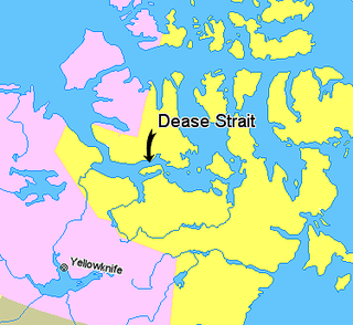
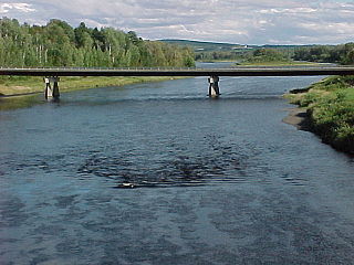
The Kent Peninsula is a large peninsula, almost totally surrounded by water, in Nunavut's northern Canadian Arctic mainland. Were it not for a 5-mile isthmus at the southeast corner it would be a long island parallel to the coast. From the isthmus it extends 105 mi (169 km) westward into the Coronation Gulf. To the south, Melville Sound separates it from the mainland. To the north is Dease Strait and then Victoria Island. To the west is Coronation Gulf and to the east, Queen Maud Gulf. Cape Flinders marks the western tip of the peninsula, Cape Franklin is at the northwestern point, and Cape Alexander marks the northeastern point.
Jupiter Glacier is a glacier on the east coast of Alexander Island, Antarctica, 10 nautical miles (19 km) long and 5 nautical miles (9 km) wide at its mouth, which flows east into George VI Sound to the south of Ablation Valley. It was first photographed from the air on November 23, 1935, by Lincoln Ellsworth and mapped from these photos by W.L.G. Joerg. It was roughly surveyed in 1936 by the British Graham Land Expedition, and was named for the planet Jupiter by the Falkland Islands Dependencies Survey following their surveys in 1948 and 1949.
Planet Heights is a series of summits running along an ice-free ridge, extending 24 nautical miles (44 km) in a north-south direction between the southernmost extremity of the LeMay Range and George VI Sound in the east part of Alexander Island, Antarctica. Many landforms and nearby features are named in association with this mountain range, some of these include landforms named after astronomers, satellites, planets and other things related to astrology and astrophysics. The mountain range was first mapped from air photos taken by the Ronne Antarctic Research Expedition (RARE), 1947–48, by Searle of the Falkland Islands Dependencies Survey (FIDS) in 1960. Named by the United Kingdom Antarctic Place-Names Committee (UK-APC) from association with the nearby glaciers named for planets of the solar system. The only planet that is not featured in any of these glaciers is the planet Earth, as there are no glaciers named "Earth Glacier" and this glacier does not exist.
Horton Glacier is a glacier at the east side of Mount Barre and Mount Gaudry, flowing southeast from Adelaide Island into Ryder Bay, Antarctica. It was named by the UK Antarctic Place-Names Committee in 1977 for Colin P. Horton, a British Antarctic Survey builder at the nearby Rothera Station, 1976–77.

The Ablation Point – Ganymede Heights Antarctic Specially Protected Area is a 180 km2 mountainous tract of land on the eastern side of Alexander Island in the Bellinghausen Sea, west of Palmer Land on the Antarctic Peninsula. It has been designated Antarctic Specially Protected Area (ASPA) No.147 for its geological, geomorphological, glaciological, limnological, and ecological values, and to protect its terrestrial and freshwater ecosystems from uncontrolled human visitation and activity.
German submarine U-737 was a Type VIIC U-boat of Nazi Germany's Kriegsmarine built for service during World War II. Her keel was laid down on 14 February 1942 by Schichau-Werke of Danzig. She was commissioned on 30 January 1943 with Leutnant zur See Wolfgang Poeschel in command.
