Ulvön Island is an island in The High Coast of the Sweden archipelago in the Gulf of Bothnia. Ulvön is the largest island in the archipelago and the most populous. There is a South Ulvön Island as well as the main Ulvön Island .
An island or isle is any piece of sub-continental land that is surrounded by water. Very small islands such as emergent land features on atolls can be called islets, skerries, cays or keys. An island in a river or a lake island may be called an eyot or ait, and a small island off the coast may be called a holm. A grouping of geographically or geologically related islands is called an archipelago, such as the Philippines.
Sweden, officially the Kingdom of Sweden, is a Scandinavian Nordic country in Northern Europe. It borders Norway to the west and north and Finland to the east, and is connected to Denmark in the southwest by a bridge-tunnel across the Öresund, a strait at the Swedish-Danish border. At 450,295 square kilometres (173,860 sq mi), Sweden is the largest country in Northern Europe, the third-largest country in the European Union and the fifth largest country in Europe by area. Sweden has a total population of 10.2 million of which 2.4 million has a foreign background. It has a low population density of 22 inhabitants per square kilometre (57/sq mi). The highest concentration is in the southern half of the country.
An archipelago, sometimes called an island group or island chain, is a chain, cluster or collection of islands, or sometimes a sea containing a small number of scattered islands.
The island of Ulvön has been a major fishing island since the mid part of the 16th century. It was established as a fishery by fishermen coming from Gävle for the Baltic herring. Today fishing is a major part of the economy of Ulvön Island but tourism has become increasingly important in the 21st century, with visitor numbers increasing steadily.
Fishing is the activity of trying to catch fish. Fish are normally caught in the wild. Techniques for catching fish include hand gathering, spearing, netting, angling and trapping. “Fishing” may include catching aquatic animals other than fish, such as molluscs, cephalopods, crustaceans, and echinoderms. The term is not normally applied to catching farmed fish, or to aquatic mammals, such as whales where the term whaling is more appropriate. In addition to being caught to be eaten, fish are caught as recreational pastimes. Fishing tournaments are held, and caught fish are sometimes kept as preserved or living trophies. When bioblitzes occur, fish are typically caught, identified, and then released.
Generally, a fishery is an entity engaged in raising or harvesting fish which is determined by some authority to be a fishery. According to the FAO, a fishery is typically defined in terms of the "people involved, species or type of fish, area of water or seabed, method of fishing, class of boats, purpose of the activities or a combination of the foregoing features". The definition often includes a combination of fish and fishers in a region, the latter fishing for similar species with similar gear types.
Gävle is a city in Sweden, the seat of Gävle Municipality and the capital of Gävleborg County. It had 100 603 inhabitants in 2017, which makes it the 13th most populated city in Sweden. It is the oldest city in the historical Norrland, having received its charter in 1446 from Christopher of Bavaria. However, Gävle is far nearer the greater Stockholm region than it is to the other major settlements in Norrland.
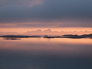
The Norwegian Sea is a marginal sea in the Arctic Ocean, northwest of Norway between the North Sea and the Greenland Sea, adjoining the Barents Sea to the northeast. In the southwest, it is separated from the Atlantic Ocean by a submarine ridge running between Iceland and the Faroe Islands. To the north, the Jan Mayen Ridge separates it from the Greenland Sea.
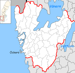
Öckerö Municipality is a municipality in Västra Götaland County in western Sweden. Its seat is located in the town of Öckerö on the main island, which is also called Öckerö.
The High Coast is a part of the coast of Sweden on the Gulf of Bothnia, in the municipalities of Kramfors, Härnösand and Örnsköldsvik, notable as an area for research on post-glacial rebound and eustacy, in which the land rises as the covering glaciers melt, a phenomenon first recognised and studied there. Since the last ice age, the land has risen 300 m, which accounts for the region's unusually tall cliffs. The High Coast is part of the Swedish/Finnish High Coast/Kvarken Archipelago World Heritage Site.
The Dahlak Archipelago is an island group located in the Red Sea near Massawa, Eritrea. It consists of two large and 124 small islands. The pearl fisheries of the archipelago have been famous since Roman times and still produce a substantial number of pearls.
The Alexander Archipelago is a 300-mile (480 km) long archipelago, or group of islands, of North America off the southeastern coast of Alaska. It contains about 1,100 islands, which are the tops of the submerged coastal mountains that rise steeply from the Pacific Ocean. Deep channels and fjords separate the islands and cut them off from the mainland. The northern part of the Inside Passage is sheltered by the islands as it winds its way among them.
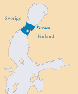
Kvarken is the narrow region in the Gulf of Bothnia separating the Bothnian Bay from the Bothnian Sea. The distance from Swedish mainland to Finnish mainland is around 80 km (50 mi) while the distance between the outmost islands is only 25 km (16 mi). The water depth in the Kvarken region is only around 25 metres (82 ft). The region also has an unusual rate of land rising at about 10 mm a year.
The Archipelago Sea is a part of the Baltic Sea between the Gulf of Bothnia, the Gulf of Finland and the Sea of Åland, within Finnish territorial waters. By some definitions it contains the largest archipelago in the world by the number of islands, although many of the islands are very small and tightly clustered.
The Tuscan Archipelago is a chain of islands between the Ligurian Sea and Tyrrhenian Sea, west of Tuscany, Italy.
The Stockholm archipelago is the largest archipelago in Sweden, and the second-largest archipelago in the Baltic Sea.
Själö or Nagu Själö or Seili is a small island, off the main islands of Nagu, in the Archipelago Sea, off the south west coast of Finland. Själö is part of the municipality of Pargas. The island is known for its church and nature, a research institute and a former hospital.
Alicudi is the westernmost of the eight islands that make up the Aeolian archipelago, a volcanic island chain north of Sicily. The island is about 40 km (25 mi) west of Lipari, has a total area of 5.2 km2 (2.0 sq mi), and is roughly circular. It is located at 38°32′45″N14°21′00″E.
Kullorsuaq is a settlement in the Avannaata municipality in northwestern Greenland. It is the northernmost settlement in the Upernavik Archipelago, located on Kullorsuaq Island at the southern end of Melville Bay, itself part of the larger Baffin Bay.
Unguja is the largest and most populated island of the Zanzibar archipelago, in Tanzania.
Replot is an island in the Kvarken, the narrowest part of the Gulf of Bothnia in the northern part of the Baltic sea. It has about 2,100 inhabitants, almost only Swedish-speaking. The size is about 150 square kilometres (58 sq mi), one of the largest islands of Finland. Replot was an independent municipality until 1973, when it was consolidated to the municipality of Korsholm, near Vaasa.
Kuroshima, also known as "Kuro Island", is an island in Taketomi Town, Okinawa, part of the Yaeyama archipelago. The island has the approximate shape of a heart symbol when viewed from the air, and is marketed as "Heart Island". The name means "Black Island".
The Thorndike Peaks are a mountain range located south of the entrance to Makinson Inlet, on the east coast of Ellesmere Island, Nunavut, Canada. They are part of the Arctic Cordillera and are virtually unexplored. There are no trees or wildlife in the Thorndike Peaks because the mountains are north of the Arctic tree line and because of the harsh cold climate.
Los Testigos Islands are a group of islands in the southeastern Caribbean Sea. They are a part of the Dependencias Federales of Venezuela.
Granskär is an island in the Kvarken, the narrowest part of the Gulf of Bothnia in the northern part of the Baltic sea. It has few inhabitants, almost all Swedish-speaking. Granskär belongs to the municipality of Vaasa.
Cauls Pond is a wetland in Anguilla, a British Overseas Territory in the Caribbean Sea. It is one of the territory’s Important Bird Areas (IBAs).
Coordinates: 63°1′19″N18°38′59″E / 63.02194°N 18.64972°E
A geographic coordinate system is a coordinate system that enables every location on Earth to be specified by a set of numbers, letters or symbols. The coordinates are often chosen such that one of the numbers represents a vertical position and two or three of the numbers represent a horizontal position; alternatively, a geographic position may be expressed in a combined three-dimensional Cartesian vector. A common choice of coordinates is latitude, longitude and elevation. To specify a location on a plane requires a map projection.
This Swedish geography article is a stub. You can help Wikipedia by expanding it. |