Unalakleet Air Force Station

Last updated
Unalakleet Air Force Station
Alaskan Air Command.png
Part of Alaskan Air Command (AAC)
USA Alaska location map.svg
Red pog.svg
Unalakleet AFS
Location of Unalakleet AFS, Alaska
Coordinates 63°55′04″N160°45′04″W / 63.91778°N 160.75111°W / 63.91778; -160.75111 (Unalakleet Radars F-20) Coordinates: 63°55′04″N160°45′04″W / 63.91778°N 160.75111°W / 63.91778; -160.75111 (Unalakleet Radars F-20)
Type Air Force Station
Site information
Controlled byFlag of the United States Air Force.svg  United States Air Force
Site history
Built 1953
In use 1958-1969
Garrison information
Garrison 718th Aircraft Control and Warning Squadron (1953-1969)
Map all coordinates using: OpenStreetMap  ·  Google Maps
Download coordinates as: KML  ·  GPX

Unalakleet Air Force Station (AAC ID: F-20) is a closed United States Air Force General Surveillance Radar station. It was located 394 miles (634 km) west of Fairbanks, Alaska.

United States Air Force Air and space warfare branch of the United States Armed Forces

The United States Air Force (USAF) is the aerial and space warfare service branch of the United States Armed Forces. It is one of the five branches of the United States Armed Forces, and one of the seven American uniformed services. Initially formed as a part of the United States Army on 1 August 1907, the USAF was established as a separate branch of the U.S. Armed Forces on 18 September 1947 with the passing of the National Security Act of 1947. It is the youngest branch of the U.S. Armed Forces, and the fourth in order of precedence. The USAF is the largest and most technologically advanced air force in the world. The Air Force articulates its core missions as air and space superiority, global integrated intelligence, surveillance, and reconnaissance, rapid global mobility, global strike, and command and control.

Fairbanks, Alaska City in Alaska, United States

Fairbanks is a home rule city and the borough seat of the Fairbanks North Star Borough in the U.S. state of Alaska.

Contents

History

Unalakleet AFS was a continental defence radar station constructed to provide the United States Air Force early warning of an attack by the Soviet Union on Alaska.

Soviet Union 1922–1991 country in Europe and Asia

The Soviet Union, officially the Union of Soviet Socialist Republics (USSR), was a socialist state in Eurasia that existed from 30 December 1922 to 26 December 1991. Nominally a union of multiple national Soviet republics, its government and economy were highly centralized. The country was a one-party state, governed by the Communist Party with Moscow as its capital in its largest republic, the Russian Soviet Federative Socialist Republic. Other major urban centres were Leningrad, Kiev, Minsk, Alma-Ata, and Novosibirsk. It spanned over 10,000 kilometres east to west across 11 time zones, and over 7,200 kilometres north to south. It had five climate zones: tundra, taiga, steppes, desert and mountains.

In 1957, 622 acres were acquired approximately 3 miles northeast of Unalakleet, Alaska for construction of the station. Using the existing port facilities at the settlement, Naval LST's and towed barges were able to land of construction equipment and material, which was transported along a gravel road to the construction site. The completed station consisted of about 25 buildings and miscellaneous support structures 63°55′07″N160°46′20″W / 63.91861°N 160.77222°W / 63.91861; -160.77222 (Unalakleet Station Area) . on a hilly site to the west of the radar station, which was located on top of a hill at 900' elevation. The station buildings were, except for the civil engineering building connected by heated hallways. As a result, personnel stationed there, with only very few exceptions, were able to wear "summer" uniforms year round, unless they had a need to go outside during the winter season. The coverings of the station's three radar towers were heated from within to keep the covering from becoming brittle from extreme cold, and thus subject to being damaged or destroyed by high winds. Tours at the station were limited to one year because of the psychological strain and physical hardships.

Unalakleet, Alaska City in Alaska, United States

Unalakleet is a city in Nome Census Area, Alaska, United States, in the western part of the state. At the 2010 census the population was 688, down from 747 in 2000. Unalakleet is known in the region and around Alaska for its salmon and king crab harvests; the residents rely heavily on caribou, ptarmigan, oogruk, and various salmon species. Unalakleet is also known for its aesthetic value, as it resides right next to the Bering Sea, immediately next to a large, clean river and has trees, tundra, and hills behind it.

The 718th Aircraft Control and Warning Squadron, activated in April 1958 and operated AN/FPS-8; AN/TPS-10D, AN/FPS-4; AN/FPS-20A, and AN/FPS-6 radars. As a surveillance station, its mission was to monitor the airspace for aircraft activity and provide information 24/7 to the air defense Direction Center at Murphy Dome AFS near Fairbanks, where it was analyzed to determine range, direction altitude speed and whether or not aircraft were friendly or hostile.

Communications were initially provided by a high frequency radio system which proved unreliable because of atmospheric disturbances. The Alaskan Air Command, after investigating various options, decided to build the White Alice Communications System, a system of Air Force-owned tropospheric scatter and microwave radio relay sites operated by the Air Force Communications Service (AFCS). The Unalakleet site 63°54′59″N160°45′34″W / 63.91639°N 160.75944°W / 63.91639; -160.75944 (Unalakleet White Alice) was activated in 1957.

White Alice Communications System

The White Alice Communications System was a United States Air Force telecommunication network with 80 radio stations constructed in Alaska during the Cold War. It used tropospheric scatter for over-the-horizon links and microwave relay for shorter line-of-sight links. Sites were characterized by large parabolic, tropospheric scatter antennas as well as smaller microwave dishes for point to point links.

Unalakleet Air Force Station was very expensive to maintain, and was inactivated due to budget reductions on 30 September 1969, its mission being taken over by other AAC surveillance radar sites with upgraded and more capable equipment.

After the station's closure, the buildings, radars and communications antennas sat derelict and abandoned for decades. In 1998 Pacific Air Forces initiated "Operation Clean Sweep", in which abandoned Cold War stations in Alaska were remediated and the land restored to its previous state. After years of neglect the facilities at the station had lost any value they had when the site was closed. The site remediation of the radar, support and White Alice communication station was carried out by the 611th Civil Engineering Squadron at Elmendorf AFB, and remediation work was completed by 2005.

Pacific Air Forces Major command of the United States Air Force responsible for the Indo-Pacific region

Pacific Air Forces (PACAF) is a Major Command (MAJCOM) of the United States Air Force and is also the air component command of the United States Indo-Pacific Command (USINDOPACOM). PACAF is headquartered at Joint Base Pearl Harbor–Hickam, Hawaii, and is one of two USAF MAJCOMs assigned outside the Continental United States, the other being the United States Air Forces in Europe - Air Forces Africa. Over the past sixty-five plus years, PACAF has been engaged in combat during the Korean and Vietnam Wars and Operations Desert Storm, Southern Watch, Northern Watch, Enduring Freedom and Iraqi Freedom.

Air Force units and assignments

Emblem of the 718th Aircraft Control and Warning Squadron 718th Aircraft Control and Warning Squadron - emblem.png
Emblem of the 718th Aircraft Control and Warning Squadron

Units:

Assignments:

See also

Related Research Articles

Alaskan Air Command 1945-1990 United States Air Force major command, predecessor of the Eleventh Air Force

Alaskan Air Command (AAC) is an inactive United States Air Force Major Command originally established in 1942 under the United States Army Air Forces. Its mission was to organize and administer the air defense system of Alaska, exercise direct control of all active measures, and coordinate all passive means of air defense. In addition, the command also supported Strategic Air Command elements operating through and around Alaska. It was redesignated Eleventh Air Force on 9 August 1990 and, concurrently, status changed from a major command of the United States Air Force to a subordinate organization of Pacific Air Forces.

Tatalina Air Force Station

Tatalina Air Force Station is a closed United States Air Force General Surveillance Radar station. It is located 13 miles (21 km) west-southwest of McGrath, Alaska.

Campion Air Force Station

Campion Air Force Station is a closed United States Air Force General Surveillance Radar station. It is located 6.4 miles (10.3 km) east-southeast of Galena, Alaska.

Tin City Long Range Radar Site

Tin City Long Range Radar Site is a United States Air Force radar station. It is located 106.3 miles (171.1 km) west-northwest of Nome, Alaska. It is the former Tin City Air Force Station.

Claysburg Air Force Station

Claysburg Air Force Station is a closed United States Air Force General Surveillance Radar station. It is located 6 miles (9.7 km) west of Claysburg, Pennsylvania. It was closed in 1961 due to budget constraints. The unit was eventually moved to Gibbsboro Air Force Station (RP-63), New Jersey.

Murphy Dome Air Force Station

Murphy Dome Air Force Station is a closed United States Air Force General Surveillance Radar station. It is located 20.4 miles (32.8 km) west-northwest of Fairbanks, Alaska.

Hanna City Air Force Station

Hanna City Air Force Station is a closed United States Air Force General Surveillance Radar station. It is located 1.6 miles (2.6 km) west-northwest of Hanna City, Illinois. It was closed in 1968. It is still in use by the Federal Aviation Administration as a Joint Surveillance System radar station.

Chandler Air Force Station closed radar station in Minnesota

Chandler Air Force Station is a closed United States Air Force General Surveillance Radar station. It is 2.2 miles (3.5 km) south of Chandler, Minnesota, on the Buffalo Ridge in section 13 of Moulton Township, Murray County. It was closed in 1969.

Olathe Air Force Station

Olathe Air Force Station is a former United States Air Force radar station that was located in Gardner, Kansas. It was located next to Naval Air Station Olathe, now the grounds of New Century AirCenter.

King Salmon Long Range Radar Site

King Salmon Air Force Station is a closed United States Air Force General Surveillance Radar station. It is located 0.4 miles (0.64 km) west of King Salmon, Alaska.

Cape Newenham Long Range Radar Site closed United States Air Force General Surveillance Radar station

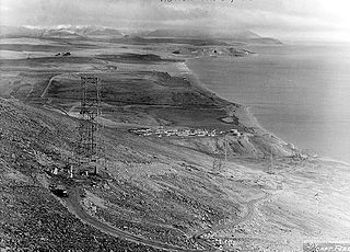
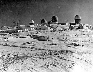
Cape Newenham Air Force Station is a closed United States Air Force General Surveillance Radar station. It is located 67.5 miles (108.6 km) west-southwest of Togiak, Alaska.

Indian Mountain Air Force Station

Indian Mountain Air Force Station is a closed United States Air Force General Surveillance Radar station. It is located 15.8 miles (25.4 km) east-southeast of Hughes, Alaska.

Cape Lisburne Air Force Station

Cape Lisburne Air Force Station is a closed United States Air Force General Surveillance Radar station. It is located 276.5 miles (445.0 km) west-southwest of Point Barrow, Alaska.

Fort Yukon Long Range Radar Site

Fort Yukon Long Range Radar Site is a radar site of the United States Air Force. It is located 1.6 miles (2.6 km) east-southeast of Fort Yukon, Alaska.

Kotzebue Air Force Station

Kotzebue Air Force Station is a closed United States Air Force General Surveillance Radar station. It is located 4 miles (6.4 km) south of Kotzebue, Alaska.

Sparrevohn Air Force Station

Sparrevohn Air Force Station is a closed United States Air Force General Surveillance Radar station. It is located 356 miles (573 km) southwest of Fairbanks, Alaska.

Cold Bay Air Force Station

Cold Bay Air Force Station is a closed United States Air Force General Surveillance Radar station. It is located 625 miles (1,006 km) southwest of Anchorage, Alaska.

Bethel Air Force Station

Bethel Air Force Station is a closed United States Air Force General Surveillance Radar station. It was located 402 miles (647 km) west of Anchorage, Alaska.

Middleton Island Air Force Station

Middleton Island Air Force Station is a closed United States Air Force General Surveillance Radar station. It was located on Middleton Island, in the Gulf of Alaska, 173 miles (278 km) south of Anchorage, Alaska.

Ohlson Mountain Air Force Station

Ohlson Mountain Air Force Station is a closed United States Air Force General Surveillance Radar station. It was located 118 miles (190 km) south-southwest of Anchorage, Alaska.

References

PD-icon.svg This article incorporates  public domain material from the Air Force Historical Research Agency website http://www.afhra.af.mil/ .