
Longitude, is a geographic coordinate that specifies the east–west position of a point on the Earth's surface, or the surface of a celestial body. It is an angular measurement, usually expressed in degrees and denoted by the Greek letter lambda (λ). Meridians connect points with the same longitude. By convention, one of these, the Prime Meridian, which passes through the Royal Observatory, Greenwich, England, was allocated the position of 0° longitude. The longitude of other places is measured as the angle east or west from the Prime Meridian, ranging from 0° at the Prime Meridian to +180° eastward and −180° westward. Specifically, it is the angle between a plane through the Prime Meridian and a plane through both poles and the location in question.

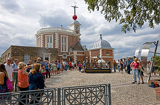
The Royal Observatory, Greenwich is an observatory situated on a hill in Greenwich Park, overlooking the River Thames. It played a major role in the history of astronomy and navigation, and is best known for the fact that the prime meridian passes through it, and thereby gave its name to Greenwich Mean Time. The ROG has the IAU observatory code of 000, the first in the list. ROG, the National Maritime Museum, the Queen's House and Cutty Sark are collectively designated Royal Museums Greenwich.
The International Meridian Conference was a conference held in October 1884 in Washington, D.C., in the United States, to determine a prime meridian for international use. The conference was held at the request of U.S. President Chester A. Arthur. The subject to discuss was the choice of "a meridian to be employed as a common zero of longitude and standard of time reckoning throughout the world". It resulted in the recommendation of the Greenwich Meridian as the international standard for zero degrees longitude.

Sir George Biddell Airy was an English mathematician and astronomer, Astronomer Royal from 1835 to 1881. His many achievements include work on planetary orbits, measuring the mean density of the Earth, a method of solution of two-dimensional problems in solid mechanics and, in his role as Astronomer Royal, establishing Greenwich as the location of the prime meridian. His reputation has been tarnished by allegations that, through his inaction, Britain lost the opportunity of priority in the discovery of Neptune.

The Ordnance Survey National Grid reference system is a system of geographic grid references used in Great Britain, distinct from latitude and longitude. It is often called British National Grid (BNG).
The Reverend Nathaniel Bliss was an English astronomer of the 18th century, serving as Britain's fourth Astronomer Royal between 1762 and 1764.
A prime meridian, based at the Royal Observatory, Greenwich, in London, England, was established by Sir George Airy in 1851. By 1884, over two-thirds of all ships and tonnage used it as the reference meridian on their charts and maps. In October of that year, at the behest of US President Chester A. Arthur, 41 delegates from 25 nations met in Washington, D.C., United States, for the International Meridian Conference. This conference selected the meridian passing through Greenwich as the official prime meridian due to its popularity. However, France abstained from the vote, and French maps continued to use the Paris meridian for several decades. In the 18th century, London lexicographer Malachy Postlethwayt published his African maps showing the "Meridian of London" intersecting the Equator a few degrees west of the later meridian and Accra, Ghana.
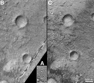
Airy-0 is a crater on Mars whose location defined the position of the prime meridian of that planet. It is about 0.5 kilometres (0.31 mi) across and lies within the larger crater Airy in the region Sinus Meridiani. The IAU Working Group on Cartographic Coordinates and Rotational Elements has now recommended setting the longitude of the Viking 1 lander as the standard. This definition maintains the position of the center of Airy-0 at 0° longitude, within the tolerance of current cartographic uncertainties.

Airy is an impact crater on Mars, named in honor of the British Astronomer, Royal Sir George Biddell Airy (1801–1892). The crater is approximately 43 kilometres (27 mi) in diameter and is located at 0.1°E 5.1°S in the Meridiani Planum region. The much smaller crater Airy-0, which defines the location of Mars' prime meridian, lies within it.
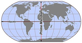
A (geographic) meridian is the half of an imaginary great circle on the Earth's surface, terminated by the North Pole and the South Pole, connecting points of equal longitude, as measured in angular degrees east or west of the Prime Meridian. The position of a point along the meridian is given by that longitude and its latitude, measured in angular degrees north or south of the Equator. Each meridian is perpendicular to all circles of latitude. Each is also the same length, being half of a great circle on the Earth's surface and therefore measuring 20,003.93 km.
The Irish grid reference system is a system of geographic grid references used for paper mapping in Ireland. The Irish grid partially overlaps the British grid, and uses a similar co-ordinate system but with a meridian more suited to its westerly location.

The Ramsden surveying instruments are those constructed by Jesse Ramsden and used in high precision geodetic surveys carried out in the period 1784 to 1853. This includes the five great theodolites—great in name, great in size and great in accuracy—used in surveys of Britain and other parts of the world. Ramsden also provided the equipment used in the measurement of the many base lines of these surveys and also the zenith telescope used in latitude determinations.
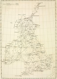
The Principal Triangulation of Britain was the first high-precision trigonometric survey of the whole of Great Britain, carried out between 1791 and 1853 under the auspices of the Board of Ordnance. The aim of the survey was to establish precise geographical coordinates of almost 300 significant landmarks which could be used as the fixed points of local topographic surveys from which maps could be drawn. In addition there was a purely scientific aim in providing precise data for geodetic calculations such as the determination of the length of meridian arcs and the figure of the Earth. Such a survey had been proposed by William Roy (1726–1790) on his completion of the Anglo-French Survey but it was only after his death that the Board of Ordnance initiated the trigonometric survey, motivated by military considerations in a time of a threatened French invasion. Most of the work was carried out under the direction of Isaac Dalby, William Mudge and Thomas Frederick Colby, but the final synthesis and report (1858) was the work of Alexander Ross Clarke. The survey stood the test of time for a century, until the Retriangulation of Great Britain between 1935 and 1962.

The Paris meridian is a meridian line running through the Paris Observatory in Paris, France – now longitude 2°20′14.03″ East. It was a long-standing rival to the Greenwich meridian as the prime meridian of the world. The Paris meridian arc or French meridian arc is the name of the meridian arc measured along the Paris meridian. The French meridian arc was important for French cartography, inasmuch as the triangulations of France began with the measurement of the French meridian arc. Moreover, the French meridian arc was important for geodesy as it was one of the meridian arcs which were measured in order to determine the figure of the Earth. The determination of the figure of the earth was a problem of the highest importance in astronomy, inasmuch as the diameter of the earth was the unit to which all celestial distances had to be referred.

The meridian circle is an instrument for timing of the passage of stars across the local meridian, an event known as a culmination, while at the same time measuring their angular distance from the nadir. These are special purpose telescopes mounted so as to allow pointing only in the meridian, the great circle through the north point of the horizon, the north celestial pole, the zenith, the south point of the horizon, the south celestial pole, and the nadir. Meridian telescopes rely on the rotation of the Earth to bring objects into their field of view and are mounted on a fixed, horizontal, east–west axis.

Col Alexander Ross Clarke FRS FRSE (1828–1914) was a British geodesist, primarily remembered for his calculation of the Principal Triangulation of Britain (1858), the calculation of the Figure of the Earth and one of the most important text books of Geodesy (1880). He was an officer of the Royal Engineers employed on the Ordnance Survey.

Botley Hill is a hill in Surrey and is the highest point of the North Downs with a height of 269.6 metres (885 ft). The Prime Meridian crosses the hill.

The IERS Reference Meridian (IRM), also called the International Reference Meridian, is the prime meridian maintained by the International Earth Rotation and Reference Systems Service (IERS). It passes about 5.3 arcseconds east of George Biddell Airy's 1851 transit circle or 102 metres (335 ft) at the latitude of the Royal Observatory, Greenwich. It is also the reference meridian of the Global Positioning System (GPS) operated by the United States Department of Defense, and of WGS84 and its two formal versions, the ideal International Terrestrial Reference System (ITRS) and its realization, the International Terrestrial Reference Frame (ITRF).
The Anglo-French Survey (1784–1790) was the survey to measure the relative situation of Greenwich Observatory and the Paris Observatory. The English operations, executed by William Roy, consisted of the measurements of bases at Hounslow Heath (1784) and Romney Marsh (1787), the measurements of the angles of the triangles (1787–1788) and finally the calculation of all the triangles (1788–1790). The survey is very significant as the first precise survey within Britain, and the forerunner of the work of the Ordnance Survey which was founded in 1791, one year after Roy's death.

