Slovenia is situated at the crossroads of central and southeast Europe, touching the Alps and bordering the Adriatic Sea. The Alps—including the Julian Alps, the Kamnik–Savinja Alps and the Karawank chain, as well as the Pohorje massif—dominate northern Slovenia along its long border to Austria. Slovenia's Adriatic coastline stretches approximately 47 km (29 mi) from Italy to Croatia. Its part south of Sava river belongs to Balkan peninsula – Balkans.

Graz is the capital of the Austrian federal state of Styria and the second-largest city in Austria, after Vienna. As of 1 January 2024, Graz had a population of 303,270. In 2023, the population of the Graz larger urban zone (LUZ) stood at 660,238. Graz is known as a college and university city, with four colleges and four universities. Combined, the city is home to more than 60,000 students. Its historic centre (Altstadt) is one of the best-preserved city centres in Central Europe.

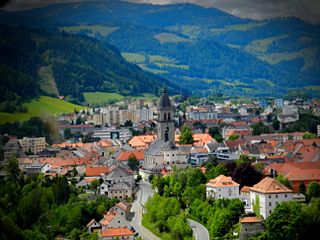
The history of Styria concerns the region roughly corresponding to the modern Austrian state of Styria and the Slovene region of Styria (Štajerska) from its settlement by Germans and Slavs in the Dark Ages until the present. This mountainous and scenic region, which became a centre for mountaineering in the 19th century, is often called the "Green March", because half of the area is covered with forests and one quarter with meadows, grasslands, vineyards and orchards. Styria is also rich in minerals, soft coal and iron, which has been mined at Erzberg since the time of the Romans. The Slovene Hills is a famous wine-producing district, stretching between Slovenia and Austria. Styria was for long the most densely populated and productive mountain region in Europe.

Austria is a predominantly mountainous country in Central Europe, approximately between Germany, Italy and Hungary. It has a total area of 83,871 square kilometres (32,383 sq mi).
Judenburg is a historic town in Styria, Austria.

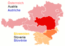
Styria is an Austrian state in the southeast of the country. With an area of approximately 16,399 km2 (6,332 sq mi), Styria is Austria's second largest state, after Lower Austria. It is bordered to the south by Slovenia, and clockwise, from the southwest, by the other Austrian states of Carinthia, Salzburg, Upper Austria, Lower Austria, and Burgenland. The state's capital is Graz, the second largest city in Austria after only Vienna.

The Mur or Mura is a river in Central Europe rising in the Hohe Tauern national park of the Central Eastern Alps in Austria with its source at 1,898 m (6,227 ft) above sea level. It is a tributary of the Drava and subsequently the Danube.

Bruck an der Mur is a city of some 15,970 people located in the district Bruck-Mürzzuschlag, in the Austrian state of Styria. It is located at the confluence of the rivers Mur and Mürz. Its manufacturing includes metal products and paper. Bruck is located on the Graz to Vienna main line, and is an important regional rail junction.

Leoben is a Styrian city in central Austria, located on the Mur river. With a population in 2023 of about 25,140 it is a local industrial centre and hosts the University of Leoben, which specialises in mining. The Peace of Leoben, an armistice between Austria and France preliminary to the Treaty of Campo Formio, was signed in Leoben in 1797.

Styria, also known as Slovenian Styria or Lower Styria to differentiate it from Austrian Styria, is a traditional region in northeastern Slovenia, comprising the southern third of the former Duchy of Styria. The population of Styria in its historical boundaries amounts to around 705,000 inhabitants, or 34.5% of the population of Slovenia. The largest city is Maribor.

Inner Austria was a term used from the late 14th to the early 17th century for the Habsburg hereditary lands south of the Semmering Pass, referring to the Imperial duchies of Styria, Carinthia and Carniola and the lands of the Austrian Littoral. The residence of the Inner Austrian archdukes and stadtholders was at the Burg castle complex in Graz.

Zeltweg is a town in Styria, Austria. It is located in the Aichfeld basin of the Mur River in Upper Styria. Larger municipalities in the vicinity are Judenburg, Knittelfeld and Fohnsdorf.

The Noric Alps is a collective term denoting various mountain ranges of the Eastern Alps. The name derives from the ancient Noricum province of the Roman Empire on the territory of present-day Austria and the adjacent Bavarian and Slovenian area.
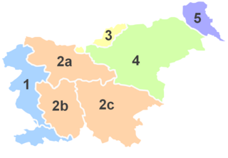
Upper Carniola is a traditional region of Slovenia, the northern mountainous part of the larger Carniola region. The largest town in the region is Kranj, and other urban centers include Kamnik, Jesenice, Domžale and Škofja Loka. It has around 300,000 inhabitants or 14% of the population of Slovenia.

The Duchy of Styria was a duchy located in modern-day southern Austria and northern Slovenia. It was a part of the Holy Roman Empire until its dissolution in 1806 and a Cisleithanian crown land of Austria-Hungary until its dissolution in 1918.

The Nomenclature of Territorial Units for Statistics (NUTS) is a geocode standard for referencing the subdivisions of Austria for statistical purposes. The standard is developed and regulated by the European Union. The NUTS standard is instrumental in delivering the European Union's Structural Funds. The NUTS code for Austria is AT and a hierarchy of three levels is established by Eurostat. Below these is a further levels of geographic organisation - the local administrative unit (LAU). In Austria, the LAU 2 is municipalities.

Laßnitzhöhe is a municipality with 2,718 inhabitants in the district of Graz-Umgebung in Styria, Austria. Laßnitz means brook in the forest and refers to the local river Laßnitz.

The following outline is provided as an overview of and topical guide to Austria:
Bruck-Mürzzuschlag is a district in Styria, Austria. It came into effect on January 1, 2013, when the merging of the districts Bruck an der Mur and Mürzzuschlag occurred. Just 2 years later, on 1 January 2015, the district was restructured in the Styria municipal structural reform and reduced from 37 to 19 towns. It consists of the following 19 municipalities:
The East Styrian Hill Country or East Styrian Hills, is a rolling, hill country region, known as Hügelland, in the southeast of the Austrian state of Styria.