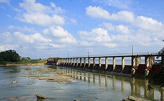
Urani Sinna urani Periya urani | |
|---|---|
| Country | |
| Province | Eastern Province |
| Time zone | UTC+5:30 (Sri Lanka Standard Time) |
Urani is a small town located in Batticaloa district Sri Lanka. It is located within Eastern province.
Urani Sinna urani Periya urani | |
|---|---|
| Country | |
| Province | Eastern Province |
| Time zone | UTC+5:30 (Sri Lanka Standard Time) |
Urani is a small town located in Batticaloa district Sri Lanka. It is located within Eastern province.
| | This Northern Province, Sri Lanka location article is a stub. You can help Wikipedia by expanding it. |

Hatton is a major town in the Nuwara Eliya District of Central Province, Sri Lanka governed by the Hatton-Dickoya Urban Council. Hatton is a major centre of the Sri Lankan tea industry.

The Sabaragamuwa Province is one of the nine provinces of Sri Lanka. Ratnapura is the capital of the province.

Kegalle is a large town in Sabaragamuwa Province of Sri Lanka. It is located on the Colombo–Kandy road, approximately 78 km (48 mi) from Colombo, 40 km (25 mi) from Kandy, 32 km (20 mi) from Kurunegala and 46 km (29 mi) from Avissavella. It is the main town in the Kegalle District, which is one of two districts which comprise Sabaragamuwa Province. The town is governed by an Urban Council.

North Central Province is one of the nine provinces of Sri Lanka. The province has an area of 10,472 km2, making it the largest province by area, and a population of 1,266,663, making it the 3rd least populated province. The city of Anuradhapura is the capital of the province.

Badulla is the capital and the largest city of Uva Province situated in the lower central hills of Sri Lanka. It is the capital city of Uva Province and the Badulla District.

Gampaha District is one of the 25 districts of Sri Lanka, the second level administrative division of the country. It is the second most populous district of Sri Lanka after Colombo District. The district is administered by a District Secretariat headed by a District Secretary appointed by the central government of Sri Lanka. The capital of the district is the town of Gampaha. The district was carved out of the northern part of Colombo District in September 1978.

Ampara District is one of the 25 districts of Sri Lanka, the second-level administrative divisions of the country. The district is administered by a District Secretariat headed by a District Secretary appointed by the central government of Sri Lanka. The capital of the district is the town of Ampara. The district was carved out of the southern part of Batticaloa District in April 1961.

Vavuniya is a city of Vavuniya District in the Northern Province of Sri Lanka. The municipality is administered by an Municipal Council. The town has been known since ancient times, but being a heavily forested area, less than 100,000 people lived in the entire district before the Sri Lankan Civil War. The city is situated as a border town that divides the Tamil and Sinhalese population. To the south of the city are the Sinhala cities and to the north are the Tamil cities. The city has a large population of Tamils, Muslims and a significant number of Sinhalese. In the early days, Vavuniya was known as Vanni due to the abundance of Vanni Trees. The Security Forces Headquarters - Wanni is located in Vavuniya.

Mullaitivu is the main town of Mullaitivu District, situated on the north-eastern coast of Northern Province, Sri Lanka. A largely fishing settlement, the town in the early twentieth century grew as an anchoring harbour of the small sailing vessels transporting goods between Colombo and Jaffna. The town has a District Secretary's office, many other government institutions and schools located in and around the area.

Kilinochchi District is one of the 25 districts of Sri Lanka, the second level administrative division of the country. The district is administered by a District Secretariat headed by a District Secretary appointed by the central government of Sri Lanka. The capital of the district is the town of Kilinochchi.
Mullaitivu District is one of the 25 districts of Sri Lanka, the second level administrative division of the country. The district is administered by a District Secretariat headed by a District Secretary appointed by the central government of Sri Lanka. The capital of the district is the town of Mullaitivu.
Tangalle is a large town in Hambantota District, Southern Province, Sri Lanka, governed by an Urban Council. It is one of the largest towns in southern province. It is located 195 km (121 mi) south of Colombo and 35 km (22 mi) east of Matara. It has a mild climate, in comparison to the rest of the district, and sandy beaches.

Balangoda is a town in Ratnapura District, Sabaragamuwa Province, Sri Lanka, governed by an urban council located 143 kilometres (89 mi) away from Colombo and 43 kilometres (27 mi) from Ratnapura on Colombo - Batticaloa Highway(A4). It is one of the largest towns of the Sabaragamuwa Province. According to the 2001 census, Balangoda has a population of 16,875 and area of 16.2 km2.
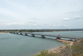
Kinniya is a town on the east coast of Sri Lanka, in the Trincomalee District of the Eastern Province. It is about 20 km (12 mi) from the city of Trincomalee and 240 km (150 mi) from Colombo. Located in Sri Lanka's dry zone, the Kinniya region often experiences hot and dry weather with very little precipitation. Kinniya Bridge is Sri Lanka's longest bridge, which attracts many tourists in the town. Being adjacent to the Trincomalee Harbour, Kinniya was devastated by the 2004 Indian Ocean tsunami.

The Central Province is one of the nine provinces of Sri Lanka. The province has an area of 5,674 km2 and a population of 2,421,148, making it the 2nd most populated province. The city of Kandy is the capital of the province.
Chilaw is a city in Puttalam District, North Western Province, Sri Lanka. It is governed by an urban council, whereas the outskirts are governed by a pradeshiya sabha of the same name. The town is located 80 kilometers away from Colombo via Negombo.
Pallai, also spelt Palai, is a small town in the Kilinochchi District, Northern Province, Sri Lanka. The town is located under the division of the Pachilaipally Divisional Secretary and is administered by the Pachilaipally Pradeshiya Sabha.
Nagoda is a small town in Sri Lanka. It is located within Southern Province.
Kaduwela is a town in the Colombo District, Western Province, Sri Lanka. It is located about 16 km (9.9 mi) from Colombo city centre on the Colombo - Avissawella Old Road and about 18 km (11 mi) from Kollupitiya on the New Kandy Road from Ethulkotte to Kandy.
Alawwa is a town and divisional secretariat of the Kurunegala District in the North Western Province of Sri Lanka. The town is considered part of the Coconut Triangle, where most of the country's coconut exports come from. The population was 63,667 according to the 2012 Sri Lankan census.