Unguja South Region, Zanzibar South Region or South Zanzibar Region is one of the 31 regions of Tanzania. The region covers an area of 854 km2 (330 sq mi). The region is comparable in size to the combined land area of the nation state of Kiribati. and the administrative region is located entirely on the island of Zanzibar. Unguja South Region is bordered on three sides to the south by Indian Ocean, northeast by Unguja North Region and northwest by Mjini Magharibi Region. The regional capital is the town of Koani. Besides being known for its Spinner dolphin populations, the region is also home to the oldest mosque in East Africa, the Kizimkazi Mosque and also historic Makunduchi town. The region has the fourth highest HDI in the country, making one of the most developed regions in the country.According to the 2012 census, the region has a total population of 94,504.
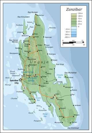
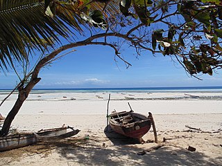
Unguja is the largest and most populated island of the Zanzibar archipelago, in Tanzania.

Mbweni is a settlement located in Mjini Magharibi Region of the Tanzanian island of Unguja, the main island of Zanzibar. It is located on the central west coast, seven kilometres south of the Zanzibari capital of Stone Town.
Bububu is a town on the Tanzanian island of Unguja, the main island of Zanzibar. It is located on the central west coast, 10 kilometres north of the Zanzibari capital of Stone Town.
Mangapwani is a town on the Tanzanian island of Unguja, the main island of Zanzibar. It is located on the northwest coast, 25 kilometres (16 mi) north of the Zanzibari capital of Stone Town.
Chukwani is a suburb on the Tanzanian island of Unguja, part of Zanzibar. It is located in the west of the island, south of Mbweni, Zanzibar, and not far from Abeid Amani Karume International Airport
Chuini is a village on the Tanzanian island of Unguja, part of Zanzibar. It is located in the west of the island, 12 kilometres north of the capital, Zanzibar City.
Chwaka is a town on the Tanzanian island of Unguja, part of Zanzibar. It is located on the east coast of the island, due east of the capital Zanzibar City, on the coast of Chwaka Bay close to the edge of Jozani-Chwaka Bay National Park.
Bumbwini is a village on the Tanzanian island of Unguja, part of Zanzibar. It is located in the northwest of the island, on a short peninsula immediately to the south of Tumbatu Island.
Bwejuu is a village on the Tanzanian island of Unguja, part of Zanzibar. It is located in the southeast of the island, on the east coast immediately south of the Michamvi Peninsula and the open, beach-rich district known as Dongwe. The larger town of Jambiani lies seven kilometres to the south.
Jendele is a village on the Tanzanian island of Unguja, part of Zanzibar. It is located in the centre of the island, on the main route between Zanzibar City and Chwaka, to the north of the Jozani-Chwaka Bay National Park.

Jambiani is a group of villages on the Tanzanian island of Unguja, part of Zanzibar. It is located on the southeast coast between Paje and Makunduchi. Jambiani has a strong seaweed culture with many farms dotting the coastline and employing 15,000 locals, mainly women. Most seaweed that is farmed here is sold to the Zanea Seaweeds Ltd company and distributed around the globe. The Island of Zanzibar produces around 11,000 tons of seaweed each year, a large amount of this coming from Jambiani sources.
Fumba is a village on the Tanzanian island of Unguja, part of Zanzibar. It is located in the southwest of the island, at the end of the Fumba Peninsula, and overlooks Menai Bay in Mjini Mgaharibi Region.
Jozani is a village located in Kusini District of Unguja South Region of the Tanzanian island of Unguja. It is located in the southeast of the island, 3.1 miles south of Chwaka Bay, close to the edge of the Jozani-Chwaka Bay National Park. It is primarily a farming community of about 800 people. located 21.7 miles south-east of Zanzibar Town off the road leading to Paje, Zanzibar. It is easily reached by public buses 309 and 310, by chartered taxi or as an organized tour from Zanzibar Town. These tours are often in combination with dolphin observation in Kizimkazi, one of Zanzibar's oldest settlements with a tiny 12th century mosque open to public. The main road on the island, connecting the west and east coasts of Zanzibar, also connects to Jozani. Besides public bus routes 9, 10 and 13, you can also get here from Zanzibar Town by dala-dala number 309, 310, 324, and 326. Jozani is a small and rural village, situated in the innermost part of the Pete Inlet Bay, immediately south of the Jozani Chwaka Bay National Park. It is one of six rural villages surrounding the park. Residents here depend to a large degree on the Jozani Forest as a source of firewood, hunting, building resources, farming, fishing, and more. The village also operates ecotourism in the Jozani Forest and has constructed a 0.6 mile boardwalk through the mangroves at the southern road entrance into the national park. Many villagers work as authorized guides for tours in the southern tip of Jozani Forest.
Kae is not a village, but the beach of Michamvi village on the Tanzanian island of Unguja, part of Zanzibar. It is one of two villages located in the east of the island at the northern tip of Michamvi Peninsula. It lies on the shore of Chwaka Bay, immediately to the west of the village of Pingwe.
Kibaoni is a village on the Tanzanian island of Unguja, part of Zanzibar. It is located in the central north of the island, four kilometres to the east of Mkokotoni.
Kitogani is a village on the Tanzanian island of Unguja, part of Zanzibar in the continent of Africa. It is located in the southeast of the island, two kilometres south of Jozani.
Mahonda is a village on the Tanzanian island of Unguja, part of Zanzibar. It is located in the northeast of the island, seven kilometres to the west of Kinyasini and 20 kilometres northeast of the capital, Zanzibar City.
Vundwe Island is a small uninhabited island in Tanzania. The islet is part of the Zanzibar Archipelago, and is located near the southwestern coast of Unguja. It lies only 300 m south of Uzi Island and it has an area of 1,4 km2. Its elevation is about 17 m above sea level. The waters surrounding the island are used as a site for commercial fishing.

