
Montpelier is the capital city of the U.S. state of Vermont and the seat of Washington County. The site of Vermont's state government, it is the least populous state capital in the United States. As of the 2020 census, the population was 8,074. However, the daytime population grows to about 21,000, due to the large number of jobs within city limits. The Vermont College of Fine Arts is located in the municipality. It was named after Montpellier, a city in the south of France.

Rutland County is a county located in the U.S. state of Vermont. As of the 2020 census, the population was 60,572, making it the second-most populous county in Vermont. Its county seat and most populous municipality is the city of Rutland.

Bennington County is a county in the U.S. state of Vermont. As of the 2020 census, the population was 37,347. The shire towns are jointly Bennington and Manchester, and the largest municipality is Bennington. The county was created in 1778.
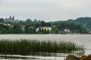
Newport is a city and the county seat of Orleans County, Vermont, United States. As of the 2020 Census, the population was 4,455. The city contains the second-largest population of any municipality in the county, and has the smallest geographic area. It is the second-smallest city by population in Vermont. Newport is also the name of a neighboring town in Orleans County.
Milton is a town in Chittenden County, Vermont, United States. As of the 2020 census, the population was 10,723. According to local legend, the town was named for the English poet John Milton, but the name most likely originated from William FitzWilliam, 4th Earl FitzWilliam, who held the title Viscount Milton and was a supporter of independence for the colonies during the American Revolution.
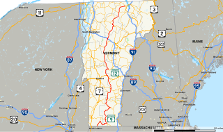
Vermont Route 100 (VT 100) is a north–south state highway in Vermont in the United States. Running through the center of the state, it travels nearly the entire length of Vermont and is 216.667 miles (349 km) long. VT 100 is the state's longest numbered highway of any type.
Vermont Route 22A (VT 22A) is a 44.738-mile-long (71.999 km) state highway in western Vermont, United States. It is the northward continuation of New York State Route 22A. Its southern end is at the New York state line in Fair Haven and its northern end is in Ferrisburgh at U.S. Route 7 (US 7). As it is an extension of NY 22A, VT 22A is a spur route of NY 22, which runs roughly parallel to VT 22A west of the state border. This is a rather unusual case of one state having a suffixed route of another state's primary route. Vermont does not currently have a "Route 22."

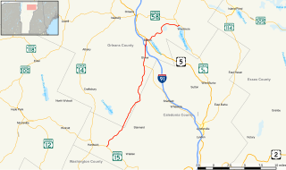
Vermont Route 5A (VT 5A) is a 26.397-mile-long (42.482 km) state highway in extreme northeastern Vermont. It is an alternate route of U.S. Route 5 (US 5) that travels along the east shore of Lake Willoughby. VT 5A begins at US 5 in West Burke and ends at US 5 and VT 105 in Derby Center, about 3 miles (4.8 km) south of the Canada–United States border.
Vermont Route 15 (VT 15) is a 68.957-mile-long (110.976 km) east–west state highway in northern Vermont, United States. Its western terminus is at U.S. Route 2 (US 2) and US 7 in Winooski and its eastern terminus is at US 2 in Danville. It is known as the Grand Army of the Republic Highway for its entirety.
Vermont Route 289 (VT 289) is a state highway located within the town of Essex, Vermont. It is a 3.94-mile-long (6.34 km) limited-access highway that extends from VT 2A southeast to VT 117 on the north bank of the Winooski River. Most of VT 289 is a two-lane undivided highway.
Vermont Route 14 (VT 14) is a 108.946-mile-long (175.332 km) north–south state highway in northeastern Vermont, United States. It extends from U.S. Route 4 (US 4) and US 5 in White River Junction to VT 100 in Newport. Between White River Junction and the city of Barre, the route parallels Interstate 89 (I-89). VT 14 was originally designated in 1922 as part of the New England road marking system. Its north end was truncated in 1926 as a result of the designation of US 2 but was extended north along an old alignment of VT 12 in the 1960s.
Vermont Route 16 (VT 16) is a 27.890-mile-long (44.885 km) state highway in northern Vermont, United States. It begins at VT 15 in Hardwick and heads northward to U.S. Route 5 (US 5) in Barton. From Barton, it heads eastward to VT 5A in Westmore. The portion of VT 16 east of US 5 is town-maintained and signed east-west. The remainder of the route is signed north-south.
Vermont Route 30 (VT 30) is a 111.870-mile-long (180.037 km) north–south state highway in the U.S. state of Vermont. VT 30 runs from U.S. Route 5 and VT 9 in Brattleboro to US 7 and VT 125 in Middlebury. The northern portion, from Poultney to Middlebury, was part of the New England road marking system's Route 30, from which VT 30 got its number. The route passes through many historic small towns, and travel writers such as those at Southern Vermont have described the route as "idyllic" and "picturesque".
Vermont Route 4A (VT 4A) is a 14.174-mile-long (22.811 km) east–west state highway in Rutland County, Vermont, United States. It runs from Fair Haven to West Rutland. VT 4A was the former alignment of U.S. Route 4 before it was relocated to an expressway.
Vermont Route 114 (VT 114) is a 53.094-mile-long (85.447 km) north–south state highway in northeastern Vermont in the United States. It runs northward from U.S. Route 5 (US 5) in Lyndon until nearing the Canada–United States border in the town of Norton; thereafter, the road continues east to the New Hampshire state line in Canaan. The vast majority of VT 114 is situated within Essex County; however, the route also passes through small, isolated portions of Caledonia and Orleans Counties.
Vermont Route 67 (VT 67) is a 4.254-mile-long (6.846 km) east–west state highway in Bennington County, Vermont, United States. It runs from a continuation of New York State Route 67 at the New York state line in Shaftsbury to VT 7A farther east in the town. VT 67 also passes through the village of North Bennington.
Vermont Route 17 (VT 17) is a 40.409-mile-long (65.032 km) state highway in western Vermont in the United States. The western terminus of the route is at the New York state line in Addison, where it connects to New York State Route 185 (NY 185) by way of the Lake Champlain Bridge. Its eastern terminus is at a junction with VT 100 in Waitsfield. VT 17 was initially much shorter than it is today, extending from the Champlain Bridge to Addison upon assignment. It was extended east through the Green Mountains to Waitsfield in 1965.
U.S. Route 4 (US 4) in the U.S. state of Vermont extends for 66.06 miles (106.31 km) between the New York state line at Fair Haven and the New Hampshire state line at White River Junction. It is one of the main arteries between New York and New Hampshire.

Vermont Route 127 (VT 127) is a state highway in Chittenden County, Vermont, United States. It currently exists in two segments: a signed, locally maintained portion in the city of Burlington and the town of Colchester, and an unsigned, state-maintained portion within the town of Colchester. The southern terminus of the signed segment is at Pearl Street in downtown Burlington. Its northern terminus is at U.S. Route 2 and U.S. Route 7 in Colchester. The unsigned segment is little more than the southern leg of a wye connection between US 2 / US 7 and VT 2A.