Nickname: Île aux Vaches Marines | |
---|---|
Geography | |
Location | Seychelles, Indian Ocean |
Coordinates | 4°41′S55°26′E / 4.683°S 55.433°E Coordinates: 4°41′S55°26′E / 4.683°S 55.433°E |
Archipelago | Inner Islands, Seychelles |
Adjacent bodies of water | Indian Ocean |
Total islands | 1 |
Major islands |
|
Area | 0.047 km2 (0.018 sq mi) |
Length | 0.2 km (0.12 mi) |
Width | 0.25 km (0.155 mi) |
Coastline | 0.9 km (0.56 mi) |
Highest elevation | 54 m (177 ft) |
Highest point | Vache |
Administration | |
Group | Granitic Seychelles |
Sub-Group | Mahe Islands |
Districts | Grand'Anse Mahé |
Demographics | |
Population | 0 (2014) |
Pop. density | 0 /km2 (0 /sq mi) |
Additional information | |
Time zone | |
ISO code | SC-13 |
Official website | www |
Île aux Vaches Marines is one of many islands in the Seychelles, lying in the west shores of Mahe. [1] Île aux Vaches Marines is a granite rock, only slightly covered with vegetation. The island is a popular nesting site for sea-birds. The rocks "Les Trois Dames" are not far from it but are usually hidden by heavily breaking seas.
Seychelles, officially the Republic of Seychelles, is an archipelago country in the Indian Ocean. The capital of the 115-island country, Victoria, lies 1,500 kilometres (932 mi) east of mainland East Africa. Other nearby island countries and territories include Comoros, Mayotte, Madagascar, Réunion and Mauritius to the south; as well as the Maldives and British Indian Ocean Territory to the east. With a population of roughly 94,228, it has the smallest population of any sovereign African country.
Mahé is the largest island (157.3 km²) of Seychelles, lying in the northeast of the nation in the Indian Ocean. The population of Mahé was 77,000, as of the 2010 census. It contains the capital city of Victoria and accommodates 86% of the country's total population. The island was named after Bertrand-François Mahé de La Bourdonnais, a French governor of Isle de France.
The island belongs to Grand'Anse Mahé District. [2]
Grand'Anse Mahé is an administrative district of Seychelles located on the island of Mahé.
Aldabra is the world's second-largest coral atoll. It is situated in the Aldabra Group of islands in the Indian Ocean that are part of the Outer Islands of the Seychelles, with a distance of 1,120 km (700 mi) southwest of the capital, Victoria, on Mahé Island.
Seychelles International Airport, or Aéroport de la Pointe Larue in French, is the international airport of the Seychelles located on the island of Mahé near the capital city of Victoria. The airport is the home base and the head office of Air Seychelles and features several regional and long-haul routes due to its importance as an international leisure destination.
Praslin Island Airport also known as Iles des Palmes Airport, is an airport at Grand Anse on Praslin Island in the Seychelles.
Assumption Island is a small island in the Outer Islands of Seychelles north of Madagascar, with a distance of 1,135 km (705 mi) south-west of the capital, Victoria, on Mahé Island. In 2018, Seychelles and India signed an agreement to build and operate a joint military facility on a portion of the island. The plan stirred up public protests by activists who believed that the islands should stay out of the brewing India-China regional conflict. The agreement was declared "dead" by the Island’s opposition party.
Bird Island is the northernmost island in the Seychelles archipelago, 100 km from Mahe. The 0.94 km2 coral island is known for its birdlife, including sooty terns, fairy terns and common noddies, and for hawksbill and green turtles. It is now a private resort with 24 bungalows. It also contains a small weather station and a small landing strip Bird Island Airport which connects the island with Mahe.
Cerf Island (1.31 km2) lies 4 km off the northeast coast of Mahé in the Seychelles.
The Outer Islands or Coralline Seychelles (archipelago) is a collective term for those islands of the Seychelles that are not on the shallow Seychelles Bank which defines the location of the granitic Inner Islands archipelago to the east. The local Seychellois Creole name for the outer islands is Zil Elwannyen Sesel, while the French name is Îles Eloignées. They are all of coral formation, and in the western Indian Ocean.
Coëtivy Island is a small coral island in the Seychelles 290 km (180 mi) south of Mahé, at 07°08′S56°16′E.
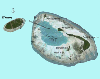
D'Arros Island is part of the Amirante Islands group, which are in the Outer Islands coral archipelago of the Seychelles islands and nation. The island is located west of the granitic Inner Seychelles archipelago, with a distance of 255 km south of Victoria, Seychelles.
Sainte Anne Marine National Park lies about 5 km from Victoria, the capital city of the Seychelles, and encompasses eight small islands.
The Granitic Seychelles are the islands in the Seychelles which lie in central position on the Seychelles Bank and are composed of granite rock. They make up the majority of the Inner Islands, which in addition include the coral islands along of the rim of the Seychelles Bank, namely Bird Island and Denis Island.
Cow Island may refer to:
The Mahé highlands and surrounding areas Important Bird Area occupy the central and north-western part of the island of Mahé in the Seychelles archipelago of the western Indian Ocean.
Long Island is an island in Seychelles, lying in the northeast shores of Mahe.
Ile Soleil is a small artificial island (0.14 km²) in the Seychelles, lying 50m off the east coast of Mahé, near the runway of the Seychelles International Airport.
Ile aux Souris is an island in Seychelles, lying in the eastern shores of Mahe.
Aurore Island is an artificial island in Seychelles, lying 2 km from the capital Victoria.
This Seychelles location article is a stub. You can help Wikipedia by expanding it. |