
The Papaloapan River is one of the main rivers of the Mexican state of Veracruz. Its name comes from the Nahuatl papaloapan meaning "river of the butterflies".
San Juan Bautista is the Spanish-language name of Saint John the Baptist. It may refer to:
Federal Highway 182 is a Federal Highway of Mexico. The highway travels from San Juan Bautista Tuxtepec, Oaxaca in the east to Teotitlán de Flores Magón, Oaxaca in the west.

Abejones is a town and municipality in Oaxaca in south-western Mexico. The municipality covers an area of 122.48 km2. It is part of the Ixtlán District in the Sierra Norte de Oaxaca region. It shares borders with San Pablo Macuiltianguis to the north, with Santa Ana Yareni and Santa María Jaltianguis to the south, with San Juan Bautista Atatlahuca, San Miguel Aloapam and San Juan Bautista Jayacatlán to the west, and with San Pablo Macuiltianguis, San Juan Atepec and San Juan Evangelista Analco to the east. Its approximately 94 km from the city of Oaxaca. This area has a very uneven terrain and there is no hectare that is a complete level in the whole municipality. The local mountains are called the Sierra Marcos Pérez and some of its mountains reach the three thousand meters. It is quite a dry region but the cold weather helps some fruit trees and forests. The only river near is the Rio Grande. As of 2005, the municipality had a total population of 1114.
San Juan Bautista Atatlahuca is a town and municipality in Oaxaca in south-western Mexico. The municipality covers an area of 196.48 km². It is part of the Etla District in the Valles Centrales region. As of 2005, the municipality had a total population of 1384.
San Juan Bautista Guelache is a town and municipality in Oaxaca in south-western Mexico. The municipality covers an area of 70.17 km². It is part of the Etla District in the Valles Centrales region. As of 2005, the municipality had a total population of 4912.
San Juan Bautista Jayacatlán is a town and municipality in Oaxaca in south-western Mexico. The municipality covers an area of 173.51 km². It is part of the Etla District in the Valles Centrales region. As of 2005, the municipality had a total population of 1254.
San Juan Bautista lo de Soto is a town and municipality in Oaxaca in south-western Mexico. The municipality covers an area of 63.8 km². It is located in the Jamiltepec District in the west of the Costa Region.
San Juan Bautista Suchitepec is a town and municipality in Oaxaca in south-western Mexico. The municipality covers an area of 38.28 km². It is part of the Huajuapan District in the north of the Mixteca Region.
San Juan Bautista Tlacoatzintepec is a town and municipality in Oaxaca in south-western Mexico. The municipality covers an area of 183.7 km². It is part of Cuicatlán District in the north of the Cañada Region.
San Juan Bautista Valle Nacional is a town and municipality in Oaxaca in south-western Mexico. The municipality covers an area of 394.23 km² within the Sierra Juárez mountains. It is part of the Tuxtepec District of the Papaloapan Region. The town lies on the north bank of the Valle Nacional River, a tributary of the Papaloapan River.
San Juan Guelavía is a town and municipality in Oaxaca in south-western Mexico. The municipality covers an area of 17.86 km². It is part of the Tlacolula District in the east of the Valles Centrales Region.
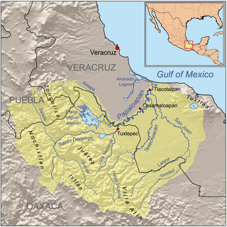
The Santo Domingo River in Oaxaca state, Mexico is one of the main tributaries of the Papaloapan River, rising in the Sierra Madre de Oaxaca and flowing east towards San Juan Bautista Tuxtepec, above which it joins with the Valle Nacional River to form the Papaloapan. Carrying sediment from the mountains, it was a major cause of flooding in the coastal plain of Veracruz by reducing the capacity of the Papaloapan to drain the plains. To alleviate these problems, the Cerro de Oro Dam was constructed on the river just above the junction with the Valle Nacional, completed in 1989. The dam extended the reservoir formed by the Miguel Alemán Dam, located on the Tonto River.

The Cuenca del Papaloapan Region is in the north of the state of Oaxaca, Mexico where the foothills of the Sierra Madre de Oaxaca meet the coastal plain of Veracruz. The principal city is San Juan Bautista Tuxtepec, the second largest in Oaxaca state.
Etla District is located in the north of the Valles Centrales Region of the State of Oaxaca, Mexico.
Tuxtepec District is located in the north of the Papaloapan Region of the State of Oaxaca, Mexico.
Jamiltepec District is located in the west of the Costa Region of the State of Oaxaca, Mexico.
Silacayoapam District is located in the northwest of the Mixteca Region of the State of Oaxaca, Mexico.

The Benito Juárez National Park is in the Valles Centrales Region of Oaxaca, Mexico, and includes parts of the municipalities of San Felipe Tejalapam and San Andres Huayapan. The southern boundary of the park is about 5 kilometers north of the City of Oaxaca. The park was established in 1937 during the presidency of General Lazaro Cardenas del Rio, and is named after President Benito Juárez, who was a native of Oaxaca.


