
La Piedad de Cabadas is a city and its surrounding municipality located at in the north-west of the Mexican state of Michoacán, bordering Jalisco and Guanajuato. The original colonial name was San Sebastián. It is bordered by the town of Santa Ana Pacueco, Guanajuato. Both towns straddle the Lerma River. La Piedad's population was 99,837 inhabitants in the 2010 census. The municipality has an area of 284.11 km². It is bordered by the states of Jalisco and Guanajuato.

Unión de San Antonio is a town and municipality located in the Mexican state of Jalisco. It is named after Saint Anthony of Padua since the first church built there was in his honor. As of 2005, the municipality had a population of 15,484. It is located about 32 km (20 mi) west of León, Guanajuato. The main local industry is agriculture, including maize, wheat, beans, and livestock.

The municipality of Ensenada, with a land area of 52,482.40 km2 (20,263.57 sq mi), takes up the majority of the state of Baja California. It is the largest municipality in Mexico and in the Americas by area. It contains all of Baja California apart from a strip at the north and, at the northeast extremity of the state, the municipality of Mexicali. It is bordered by the Pacific Ocean on the west, the Gulf of California on the east, and by all of the other municipalities in Baja California on the North. Its municipal seat is Ensenada, which lies near the northwest corner of the municipality, although almost all of the municipality's territory lies far to its southeast. Its current municipal president is Enrique Pelayo Torres. A major port is planned to be built in Punta Colonet, a largely uninhabited area 80 km (50 mi) south of the city of Ensenada. Located offshore, Guadalupe Island is part of the municipality, making Ensenada the westernmost municipality of Latin America.
Jalostotitlán is a town and municipality located in the northeast corner of the state of Jalisco, Mexico, in a region known as Los Altos.

Arandas is a municipality of the Altos Sur region of the state of Jalisco in Mexico. Arandas is also the name of the municipality's main township and the center of the municipal government. It is approximately 2 hours east of Guadalajara.
San Sebastián del Oeste is a town and municipality, located on the western part of Jalisco state, Mexico, between 20°39’45’’ - 21°02’30’’ N and 104°35’00’’ - 104°51’00’’ W, at a height of 1,480 metres (4,856 ft).
Los Ramones is the name of a municipality and its corresponding seat of government and main population center in Mexican state of Nuevo Leon.
Valle de Guadalupe may refer to:
Valle de Guadalupe is a village in Michoacán, Mexico.
Valle de Guadalupe is a village in Querétaro, Mexico. It is located in the municipality of Landa de Matamoros. It has 834 inhabitants, and is located at 1620 meters above sea level.
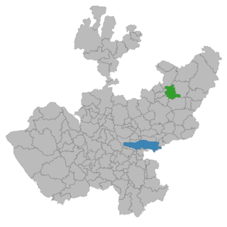
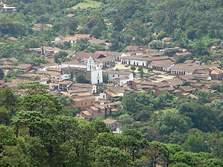
Valle de Guadalupe is a small town in Jalisco, Mexico.

Villa Hidalgo is a town and municipality in the state of Jalisco in Mexico.
Teocaltiche is a town and municipality in the central-western Mexican state of Jalisco. Teocaltiche is located in the northeastern highlands region of Jalisco, commonly referred to in Spanish as "Los Altos de Jalisco". The grasshopper or "chapulin" is a popular icon for the town.

Calvillo is a municipality in the Mexican state of Aguascalientes. The city of Calvillo, the second largest in the state, serves as the municipal seat. It is located to the western part of the state, at about 52 kilometers of the city of Aguascalientes. It stands at 21°51′N102°43′W in the southwestern corner of the state. It is bounded by Jalisco and Zacatecas. The municipality, which has an area of 931.26 km², reported a population of 54,136 by 2010. The town of Ojocaliente is another significant community in the municipality. Calvillo is one of the richest, most prosperous municipalities in Aguascalientes.

Degollado is a small town and municipality in the eastern highlands of the Mexican state of Jalisco. The municipality encompasses Huascato, Los Ranchitos, La Vibora, Buenos Aires, Las Limas, Altamira, La Chancla and El Corral de Piedra.
Rancho El Tejón was a 97,617-acre (395.04 km2) Mexican land grant in the Tehachapi Mountains and northeastern San Emigdio Mountains, in present day Kern County, California. It was granted in 1843 by Governor Manuel Micheltorena to José Antonio Aguirre and Ygnacio del Valle.
Colonia Valle Gómez is a colonia or neighborhood in the Venustiano Carranza borough of Mexico City, just north of the city’s historic center. The boundaries of the colonia are marked by the following streets: Ferrocarril Hidalgo to the east, Calzada de Guadalupe to the west, Río Consulado to the north and Platino Street to the south. Schools include Campanitas Preschool (public), Cendi Gdf Mapimi Primary (public), Centro de Estudios Tecnologicos Manchester Technical School (private), Cideco Preschool (private), Felipe Carrillo Puerto Primary (public), and Joaquin Miranda Carreon Primary (private).

Church of Our Lady of Guadalupe, known locally as La Iglesia de Nuestra Senora de Guadalupe, is a church building in Puerto Vallarta, Jalisco, Mexico. The church has been called "one of the most endearing" of the city's landmarks. It is open daily, with services in English available on Saturdays and mass in both Spanish and English on Sundays.

The Cathedral Basilica of Our Lady of St. John of the Lakes also called San Juan de los Lagos Cathedral It is a Catholic church located in the city of San Juan de los Lagos, in the state of Jalisco,Mexico, headquarters of the diocese of San Juan de los Lagos. This Cathedral-Basilica ranks second in the number of visitors in the country after the Basilica of Our Lady of Guadalupe.

The Our Lady of Guadalupe Cathedral Also Ciudad Juárez Cathedral Is the name of a Catholic cathedral church dedicated to the Virgin of Guadalupe, that is located in Ciudad Juárez in the border state of Chihuahua, in Mexico, in the area called Historical Center. It was built in the middle of the second half of the twentieth century and is attached to the old and still preserved Franciscan mission, founded in the 17th century, in the then Paso del Norte.


