
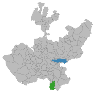
Atoyac Municipality is a municipality in the Mexican state of Jalisco. The administrative centre for the municipality is located in the town of Atoyac, Jalisco.

The Jalisco Stadium is a football stadium located in Guadalajara, Mexico. It is the third largest Mexican football stadium behind Estadio Azteca and Estadio Olímpico Universitario. The facility is located in the city of Guadalajara, Jalisco, 400 kilometers north-west of Mexico City, and has a maximum capacity of 55,110 spectators.

Tecalitlán is a city and municipality in the central Pacific coastal state of Jalisco, Mexico. Located just south of Ciudad Guzmán, its population was 13,265 per the 1990 census.

Tamazula de Gordiano is a city in the Mexican state of Jalisco. The word "tamazula" comes from the Nahuatl word tamazullan, which means "place or lagoon of toads."

Arandas is a municipality of the Altos Sur region of the state of Jalisco in Mexico. Arandas is also the name of the municipality's main township and the center of the municipal government. It is approximately 2 hours east of Guadalajara.

Benito Juárez Municipality is a Mexican municipality located in the southern extreme of the state of Zacatecas on the edge of the Canyon of Tlaltenango.
Pihuamo is a town and municipality located in the state of Jalisco in Mexico.
Peribán is a municipality located in the western part of the Mexican state of Michoacán. The municipality has an area of 331.87 square kilometres and is bordered to the north by the municipality of Los Reyes, to the east by Uruapan, to the southeast by Tancítaro, to the south by Buenavista, and to the west by the state of Jalisco. The municipality had a population of 20,965 inhabitants according to the 2005 census. Its municipal seat is the city of Peribán de Ramos.
Valle de Guadalupe may refer to:
Valle de Guadalupe is a village in Jalisco, Mexico.
Valle de Guadalupe is a village in Michoacán, Mexico.

Villa Hidalgo is a town and municipality in the state of Jalisco in Mexico.

Quitupan is a town and municipality located in the southeastern region of the Mexican state of Jalisco. The name Quitupan comes from the word "Quitoa" or "Quitla", which means "place where declarations or treaties come from" or "place that is located above".
Tuxpan is a town and municipality in the Mexican state of Jalisco. The name "Tuxpan" comes from the Nahuatl word tochpan, a word used to describe where rabbits live or possibly place of abundant rabbits. Some others translate it as a location above the river.
The Findlay Group is a group of islands in the Canadian Arctic Archipelago in Qikiqtaaluk Region, Nunavut. This Arctic Ocean group consists of Lougheed Island, Stupart Island, Edmund Walker Island, Grosvenor Island and Patterson Island.
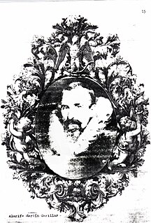
Martín Casillas (1556–1618) was a Spanish architect (″alarife″, best known for designing the Cathedral of Guadalajara in Jalisco, Mexico. His place of birth is disputed between extremeñas from Almendralejo or Trujillo. is documented his training alongside Francisco Becerra, who was unable to reach new Spain as an apprentice in 1573, although another option barajada is that you arrived later along with teammate Alonso Pablos workshop. It worked then and at least until 1585, in «Middle samples» the Cathedral of Mexico, the work directed by Claudio de Arciniega, moving then to Guadalajara city Guadalajara. from his work in Jalisco is more documentation, including the transfer of land in Valle de Guadalupe. Theatre "Architect Martin Casillas" of Guadalajara was baptized in his memory.

Tapalpa is a town and municipality, in Jalisco state of central-western Mexico.
Colonia Valle Gómez is a colonia or neighborhood in the Venustiano Carranza borough of Mexico City, just north of the city’s historic center. The boundaries of the colonia are marked by the following streets: Ferrocarril Hidalgo to the east, Calzada de Guadalupe to the west, Río Consulado to the north and Platino Street to the south. Schools include Campanitas Preschool (public), Cendi Gdf Mapimi Primary (public), Centro de Estudios Tecnologicos Manchester Technical School (private), Cideco Preschool (private), Felipe Carrillo Puerto Primary (public), and Joaquin Miranda Carreon Primary (private).
The small town Los Mazos is situated in the Municipality of Tuxpan, Jalisco. It has approximately 190 inhabitants. Los Mazos sits at a height of 1,780 meters. Located on the skirts of a couple of volcanoes, an inactive one called El Nevado de Colima and an active one called the Volcan de Colima, also known as the Volcan de Fuego or "fire volcano". It is located near the city of Tuxpan and is located within its municipality. The town of Los Mazos once belonged to a bigger hacienda and shares a common water system and storage pools called "tanques" with Las Canoas, another few tanques are located throughout the region. The tanques are constructed with cement and stone, and coated in a mixture of cement and ox blood giving them a dark ocher look, these tanques were used to store potable, cattle and plant water.

Church of Our Lady of Guadalupe, known locally as La Iglesia de Nuestra Senora de Guadalupe, is a church building in Puerto Vallarta, Jalisco, Mexico. The church has been called "one of the most endearing" of the city's landmarks. It is open daily, with services in English available on Saturdays and mass in both Spanish and English on Sundays.


