
Mount Field National Park is a national park in Tasmania, Australia, 64 km northwest of Hobart. The landscape ranges from eucalyptus temperate rainforest to alpine moorland, rising to 1,434 metres (4,705 ft) at the summit of Mount Field West.

Mount Canobolas, a mountain on a spur of the Great Dividing Range, is located in the Central Tablelands region of New South Wales, Australia.

Mount Keira is a suburb and mountain in the Illawarra region of New South Wales, Australia.

Mount Gambier, also known as Berrin, is the second most populated city in South Australia, with an estimated urban population of 29,940 as of 2021. The city is located on the slopes of Mount Gambier, a volcano in the south east of the state, about 450 kilometres (280 mi) south-east of the capital Adelaide and just 17 kilometres (11 mi) from the Victorian border. The traditional owners of the area are the Bungandidj people. Mount Gambier is the most important settlement in the Limestone Coast region and the seat of government for both the City of Mount Gambier and the District Council of Grant.

Blue Lake / Warwar is a large, monomictic, crater lake located in a dormant volcanic maar associated with the Mount Gambier maar complex. The lake is situated near Mount Gambier in the Limestone Coast region of South Australia, and is one of four volcanic crater lakes originally on Mount Gambier maar. Of the four lakes, only two remain, the other one being Valley Lake / Ketla Malpi; the other two, Leg of Mutton Lake / Yatton Loo and Brownes Lake / Kroweratwari, have dried up as the water table has dropped.
The Kangaroo River is a perennial river of the Shoalhaven catchment located in the Southern Highlands and Illawarra regions of New South Wales, Australia.
The D'Aguilar Range is a mountain range near Brisbane, Queensland, Australia. The town of Dayboro is situated on the lower foothills midway along the range and the Sunshine Coast Hinterland town of Mooloolah lies at the northernmost point of the range. Many residential areas line its eastern slopes including the town of Samford and the suburb of Ferny Hills. In the west, numerous ridges and gullies are heavily forested and designated as state forest or national park.
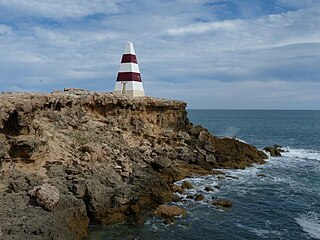
Port MacDonnell, originally known as Ngaranga is the southernmost town in South Australia. The small port located in the Limestone Coast region about 477 kilometres (296 mi) southeast of Adelaide and 28 kilometres (17 mi) south of Mount Gambier in the District Council of Grant local government area. The 2016 Australian census which was conducted in August 2016 reports that the locality of Port MacDonnell had a population of 847 of which 671 lived in its town centre. Once a busy shipping port, the town now relies heavily on its fishing and summer tourism industries, particularly rock lobster harvest industry, proclaiming itself "Australia's Southern Rock Lobster Capital".

The District Council of Grant is a local government area located in the Limestone Coast region of South Australia, and is the southernmost council in the state.

Mount Gambier, also known as Berrin, is a maar complex in South Australia associated with the Newer Volcanics Province. The complex contains four maars, the most well-known one of which is Blue Lake / Warwar. The others are Valley Lake / Ketla Malpi, Leg of Mutton Lake / Yatton Loo and Brownes Lake / Kroweratwari. The complex is partially surrounded by the city of Mount Gambier.

Piccaninnie Ponds Conservation Park, formerly the Piccaninnie Ponds National Park, is a protected area of 862 hectares located in southeastern South Australia near Mount Gambier.

Ewens Ponds is a series of three water-filled limestone sinkholes in the Australian state of South Australia located in the gazetted locality of Eight Mile Creek, on the watercourse of Eight Mile Creek about 25 kilometres south of Mount Gambier and 8.4 kilometres east of Port Macdonnell. The ponds are popular with recreational divers due to underwater visibility of up to 80 metres. It has a large fish population including the endangered golden pygmy perch. Ewens Ponds has been part of the Ewens Ponds Conservation Park since 1976.

The Howqua River, a minor inland perennial river of the Goulburn Broken catchment, part of the Murray-Darling basin, is located in the alpine region of the Australian state of Victoria. The headwaters of the Howqua River rise below Mount Howitt in the western slopes of the Victorian Alps, and descend to flow into the Goulburn River within Lake Eildon.
The Bungandidj people are an Aboriginal Australian people from the Mount Gambier region in south-eastern South Australia, and also in western Victoria. Their language is the Bungandidj language. Bungandidj was historically frequently rendered as Boandik, Buandig, or Booandik.

South Australia is an Australian state, situated in the southern central part of the country, and featuring some low-lying mountain ranges, the most significant being the Mount Lofty Ranges, which extend into the state's capital city, Adelaide, which comprises most of the state's population. Adelaide is situated on the eastern shores of Gulf St Vincent, on the Adelaide Plains, north of the Fleurieu Peninsula, between Gulf St Vincent and the low-lying Mount Lofty Ranges. The state of South Australia, which stretches along the coast of the continent and has boundaries with every other state in Australia, with the exception of the Australian Capital Territory and Tasmania. The Western Australia border has a history with South Australia, involving the South Australian Government Astronomer, Dodwell and the Western Australian Government Astronomer, Curlewis in the 1920s to mark the border on the ground.
Guichen Bay, is a bay located on the south-east coast of the Australian state of South Australia about 115 kilometres northwest of the regional city of Mount Gambier and about 270 kilometres south-southeast of the state capital of Adelaide. It was named in 1802 by the Baudin expedition of 1800-03 after Luc Urbain de Bouëxic, comte de Guichen. The town of Robe is located at the southern end of the bay.
Nene Valley Conservation Park is a protected area in the Australian state of South Australia located in the localities of Blackfellows Caves and Nene Valley in the state's south-east about 35 kilometres south west of the municipal seat of Mount Gambier and about 18 kilometres west north west of Port MacDonnell.

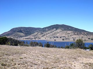
Mount Schank is a locality in the Australian state of South Australia located about 385 kilometres south-east of the state capital of Adelaide and 14 kilometres south of the municipal seat of Mount Gambier in the south-east of the state.

The Hooker Valley Track is the most popular short walking track within the Aoraki / Mount Cook National Park in New Zealand. At only 5 kilometres (3.1 mi) length and gaining only about 100 m (330 ft) in height, the well formed track can be walked by tourists with a wide range of level of fitness.
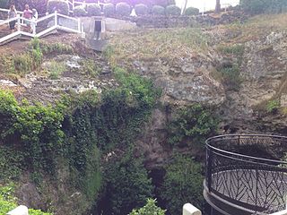
Cave Garden / Thugi, formerly known as the Cave Gardens, is a garden located in the centre of Mount Gambier, South Australia, that contains a 30 m (98 ft) deep cave. The cave was initially used as a water source for the town.


