Related Research Articles
Vanuatu, officially the Republic of Vanuatu, is an island country in Melanesia, located in the South Pacific Ocean. The archipelago, which is of volcanic origin, is 1,750 km (1,090 mi) east of northern Australia, 540 km (340 mi) northeast of New Caledonia, east of New Guinea, southeast of Solomon Islands, and west of Fiji.

Demographic features of the population of Vanuatu include population density, ethnicity, education level, health of the populace, economic status, religious affiliations and other aspects. 4% of the people living in Vanuatu are Europeans.

Port Vila, or simply Vila, is the capital and largest city of Vanuatu. It is located on the island of Efate.

Vanuatu has been divided into six provinces since 1994. The names in English of all provinces are derived from the initial letters of their constituent islands:

The English-speaking world comprises the 88 countries and territories where English is either an official, administrative, or cultural language. As of the 2000s, nearly 2 billion people globally speak English, making it the largest language by number of speakers, and the third largest language by number of native speakers, as well as the most geographically widespread language. The regions where English is natively spoken by the majority of the population, due to cultural connections to England, are termed "the Anglosphere". Speakers of English are called Anglophones.
Shefa is one of the six provinces of Vanuatu, located in the center of the country and including the islands of Epi and Efate and the Shepherd Islands. The province's name is derived from the initial letters of SHepherd and EFAte. It has a population of 78,723 people and an area of 1,455 km2. Its capital is Port Vila, which is also the capital of the nation.

Malo is an island in Vanuatu 3 km (1.9 mi) off the southern coast of Vanuatu's largest island, Espiritu Santo, in Sanma Province. It has a circumference of 55 km (34 mi) and an area of 180 km2 (69 sq mi). It is 17 kilometres or 11 miles long, and 13 kilometres or 8.1 miles wide. The highest point on the island is Mount Malo.

Erromango is the fourth largest island in the Vanuatu archipelago. With a land area of 891.9 square kilometres (344.4 sq mi) it is the largest island in Tafea Province, the southernmost of Vanuatu's six administrative regions.
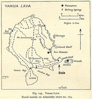
Vanua Lava is the second largest of the Banks Islands in Torba Province, Vanuatu, after slightly larger Gaua.
Tegua is an island in Vanuatu's Torres Islands chain, located in Torba Province.
VNSO may stand for:

Merig is a small island located 20 kilometres east of Gaua, in the Banks Islands of northern Vanuatu.
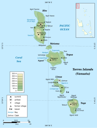
Lo is an island in the Torres group of islands, in northern Vanuatu. The island is located 2.25 miles from the Toga Island. As of 2009, the population of the island was 210. They speak the Lo dialect of the Lo-Toga language.

Rah or Ra is a small coral islet of 0.5 km2 (0.19 sq mi), located in the Banks group of northern Vanuatu. The same name also refers to the single village which is situated within this islet. There are massive rocks on the island.
The 2009 Census of Vanuatu was conducted on 16 November 2009. The census revealed growth by an average of 2.3 percent a year since the previous census in 1999.

The Maskelyne Islands, often abbreviated as the Maskelynes, are a small chain of low islands that forms part of Vanuatu in the Pacific Ocean. Among the islands are Awei, Avock, Leumanang, Uluveo, and Vulai. Uluveo is the main island in the group and has three villages.
Life expectancy in Vanuatu is 67 years for men, and 70 years for women.
Arseo Island is a small, uninhabited island in the Malampa Province of Vanuatu in the Pacific Ocean. The estimated terrain elevation above sea level is some 172 metres (564 ft). There are two small neighboring islands: Leumanang and Varo.