
Bosnia and Herzegovina, sometimes known as Bosnia-Herzegovina and informally as Bosnia, is a country in Southeast Europe, situated on the Balkan Peninsula. It borders Serbia to the east, Montenegro to the southeast, and Croatia to the north and southwest. In the south it has a 20 kilometres long coast on the Adriatic Sea, with the town of Neum being its only access to the sea. Bosnia has a moderate continental climate with hot summers and cold, snowy winters. In the central and eastern regions, the geography is mountainous, in the northwest it is moderately hilly, and in the northeast it is predominantly flat. Herzegovina, the smaller, southern region, has a Mediterranean climate and is mostly mountainous. Sarajevo is the capital and the largest city.

The General Framework Agreement for Peace in Bosnia and Herzegovina, also known as the Dayton Agreement or the Dayton Accords, and colloquially known as the Dayton in ex-Yugoslav parlance, is the peace agreement reached at Wright-Patterson Air Force Base near Dayton, Ohio, United States, finalised on 21 November 1995, and formally signed in Paris, on 14 December 1995. These accords put an end to the three-and-a-half-year-long Bosnian War, which was part of the much larger Yugoslav Wars.

Republika Srpska is one of the two entities of Bosnia and Herzegovina, the other being the Federation of Bosnia and Herzegovina. It is located in the north and east of the country. Its largest city and administrative centre is Banja Luka, lying on the Vrbas river, and with a population of about 138,963 people.

The Herzegovina-Neretva Canton is one of 10 cantons of the Federation of Bosnia and Herzegovina in Bosnia and Herzegovina.

Tuzla is the third-largest city of Bosnia and Herzegovina and the administrative center of Tuzla Canton of the Federation of Bosnia and Herzegovina. As of 2013, it has a population of 110,979 inhabitants.

Canton 10, is one of the ten cantons of the Federation of Bosnia and Herzegovina, a political entity of Bosnia and Herzegovina. It is the largest canton by area and eighth by population. The local government seat is in Livno, while the assembly is in Tomislavgrad. It is divided into five municipalities: Bosansko Grahovo, Drvar, Glamoč, Kupres, Tomislavgrad and one city, Livno.
The West Herzegovina Canton is one of the cantons of the Federation of Bosnia and Herzegovina. The West Herzegovina Canton is in the Herzegovina region in the southwest of Bosnia and Herzegovina. Its seat of government is in Široki Brijeg, while other municipalities within the Canton are Grude, Ljubuški and Posušje. It has 94,898 inhabitants, of whom more than 98% are ethnic Croats. Economically, it is the most developed part of Bosnia and Herzegovina.

The Neretva, also known as Narenta, is one of the largest rivers of the eastern part of the Adriatic basin. Four hydroelectric power plants with large dams provide flood protection, electicity and water storage. The Neretva is recognized for its natural environment and diverse landscapes.

Gradačac is a city located in the Tuzla Canton of the Federation of Bosnia and Herzegovina, an entity of Bosnia and Herzegovina. It is situated in the northeastern part of Bosnia and Herzegovina, roughly 40 km (25 mi) south of the Sava river. As of 2013, it has a population of 39,340 inhabitants. The city is well known for its castle.
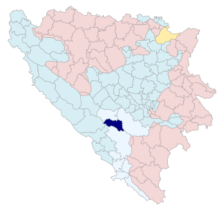
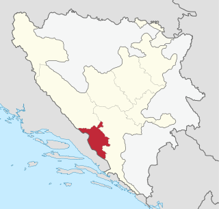
Jablanica is a town and municipality located in the Herzegovina-Neretva Canton of the Federation of Bosnia and Herzegovina, an entity of Bosnia and Herzegovina. It is situated on the Neretva river and Jablanica lake.

The Pliva is a relatively small river in central parts of Bosnia and Herzegovina, however one of the most significant in terms of natural, cultural and historical heritage and value as a natural rarity. For hundreds of years this region was the ultimate stronghold of the Bosnian Kingdom, with the town of Jajce as permanent seat of the last kings of the Bosnian Kingdom.

Blidinje plateau is a karst plateau in Bosnia and Herzegovina, situated at the heart of Dinaric Alps, between major mountains of the range, Čvrsnica, Čabulja and Vran, with characteristic karstic features such as Dugo Polje field, Blidinje Lake, Grabovica and Drežanka valleys, and others. It represents important natural, hydrogeological reservation in karst of Bosnia and Herzegovina, with significant cultural and historical heritage, and Dinarides in general.

The Drina is a 346 km (215 mi) long river in the Balkans, which forms a large portion of the border between Bosnia and Herzegovina and Serbia. It is the longest tributary of the Sava River and the longest karst river in the Dinaric Alps which belongs to the Danube River drainage basin. Its name is derived from the Roman name of the river which in turn is derived from Greek.

Konjic is a City and a town located in the Herzegovina-Neretva Canton of the Federation of Bosnia and Herzegovina, one of two entities that make up Bosnia and Herzegovina. It is located in northern Herzegovina, around 60 kilometres (37 mi) southwest of Sarajevo, in a mountainous, heavily wooded area, and is 268 m (879 ft) above sea level. The municipality extends on both sides of the Neretva River. According to the 2013 census, the city of Konjic has a population of 10,732 inhabitants, whereas the municipality has 25,148.

Herzegovina is the southern and smaller of two main geographical regions of Bosnia and Herzegovina, the other being Bosnia. It has never had strictly defined geographical, cultural or historical borders, nor has it ever been defined as an administrative whole in the geopolitical and economic subdivision of Bosnia and Herzegovina.
Blace is a village in the municipality of Konjic, Bosnia and Herzegovina.

Jezero is a village and a municipality in Republika Srpska, Bosnia and Herzegovina. As of 2013, it has a population of 1,144 inhabitants, while the village of Jezero has a population of 581 inhabitants. A small part of the village in Jajce municipality has a population of 6.

Bileća Lake is an artificial lake located in the municipality of Bileća, in the entity of Republika Srpska, Bosnia and Herzegovina, its length forming part of the Montenegrin border thus a small part being within Montenegro. The manmade lake was created by building the Grančarevo Dam an arch dam across the Trebišnjica River, which was built in 1968. It lies in the upper and central part of Trebsinjica valley, 17 km from Trebinje town and is one of the largest lakes in Bosnia and Herzegovina.
Vrtliško Lake is a part artificial, part natural lake of Bosnia and Herzegovina. It is located in the municipality of Kakanj.


