
Aconcagua, with a summit elevation of 6,960.8 metres (22,837 ft), is the highest mountain in both the Southern and Western Hemispheres. It is located in the Andes mountain range, in the Mendoza Province, Argentina, and lies 112 km (70 mi) northwest of its capital, the city of Mendoza, about five km (3.1 mi) from San Juan Province and 15 km (9.3 mi) from the international border with Chile. The mountain itself lies entirely within Argentina, immediately east of Argentina's border with Chile. The nearest higher peak is Tirich Mir in the Hindu Kush, 16,520 kilometres (10,270 mi) away. It is one of the Seven Summits.

Aneto is the highest mountain in the Pyrenees and in Aragon, and Spain's third-highest mountain, reaching a height of 3,404 metres (11,168 ft). It stands in the Spanish province of Huesca, the northernmost of all three Aragonese provinces, 4 miles south of the French border. It forms the southernmost part of the Maladeta massif. It is also still locally known as Pic de Néthou in French, that name and its variants having been in general use until the beginning of the 20th century.
Los Glaciares National Park is a federal protected area in Santa Cruz Province, Argentina.

Santa Inés Island is an island in southern Chile, part of the Tierra del Fuego archipelago and of Punta Arenas municipality, lying south west of the Brunswick Peninsula, from which is separated by the Strait of Magellan and minor islands. It is the largest island of Punta Arenas municipality and the third largest of the Tierra del Fuego archipelago, after Isla Grande and Hoste Island. Its shoreline in this area is part of the Francisco Coloane Coastal and Marine Protected Area. The rest of the island is a part of the Alacalufes National Reserve, equalling that Desolación Island and the Córdova Peninsula. This latter is located in front of the island on the other side of the Strait of Magellan and is a peninsula of Riesco Island. The island belongs to the Tierra del Fuego archipelago.

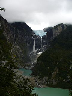
Tronador is an extinct stratovolcano in the southern Andes, located along the border between Argentina and Chile, near the Argentine city of Bariloche. The mountain was named Tronador by locals in reference to the sound of falling seracs. With an altitude of 3,470 m, Tronador stands more than 1000 m above nearby mountains in the Andean massif, making it a popular mountaineering destination. Located inside two National Parks, Nahuel Huapi in Argentina and Vicente Pérez Rosales in Chile, Tronador hosts a total of eight glaciers, which are currently retreating due to warming of the upper troposphere.

Perunika Glacier is an 8 km long and 3 km wide (average) roughly crescent-shaped glacier in eastern Livingston Island in the South Shetland Islands, Antarctica situated east of Pimpirev Glacier, south of Saedinenie Snowfield, southwest of Kaliakra Glacier, west of Huron Glacier, and north of Balkan Snowfield and the head of Huntress Glacier.
Pimpirev Glacier on Livingston Island in the South Shetland Islands, Antarctica is situated south of the glacial divide between the Drake Passage and Bransfield Strait, southeast of Tundzha Glacier, southwest of Saedinenie Snowfield, west of Perunika Glacier and east-northeast of Kamchiya Glacier. The feature extends 5.5 km in a southeast-northwest direction, and 1.8 km in northwest-southeast direction. The glacier drains southeastwards towards Pimpirev Beach, mostly terminating on the shore, and on several occasions penetrating the South Bay waters east-northeast of Ereby Point.

The Carretera Austral is the name given to Chile's Route 7. The highway runs about 1,240 kilometers (770 mi) from Puerto Montt to Villa O'Higgins through rural Patagonia.
Queulat National Park is a national park of Chile located in the Aysén del General Carlos Ibáñez del Campo Region. The park is bordered by the Cisnes River on the south side and is neighbor to Lago Rosselot National Reserve. It contains 1,541 km2 (595 sq mi) of glacier-capped mountains and virgin evergreen forests.

The Puelo River has its origin in Lake Puelo in Argentine, and flows north-west through the Andes into Chile and the Reloncaví Estuary of the Reloncaví Sound at the northern end of the Gulf of Ancud.

Puyuhuapi (Puyuguapi) is a village in southern Chile in the Aysén Region. It is located on Route 7, the Carretera Austral, where the Rio Pascal enters the head of the Puyuhuapi fjord, a small fjord off the Ventisquero Sound. Its harbor on the fjord is called Puerto Puyuhuapi. Puyuhuapi is administratively in the Chilean commune of Cisnes. In the 2002 census it had a population of 535, but by 2007 it had grown to 826. Just southwest of the village are the Puyuhuapi hot springs.

Colonia Glacier is a valley glacier located in the Northern Patagonian Ice Field, Chile. The glacier spills out to the southeast from an ice plateau north of Cerro Arenales and has its terminus about 4 km (2.5 mi) from Colonia Lake. Colonia Glacier dams two lakes; Cachet II and Arco Lake. The ice dam containing the waters of Cachet II Lake fails regularly, which generates glacial lake outburst floods.

The Manso River is a river of Rio Negro Province of Argentina and Los Lagos Region of Chile, both part of Patagonia. The Manso River is located in the Andes. It follows a winding route through snow-capped mountains and connects many glacial lakes. The Manso flows generally southward until its confluence with the Puelo River in Chile. The river while in Argentina flows through the Nahuel Huapi National Park. Most of the southern part of Nahuel Huapi is in the drainage basin of the Manso River.

Argentina Glacier is a glacier flowing northwest from Hurd Dome and terminating near Argentina Cove, South Bay, Livingston Island. The name Argentina Glacier was given in association with Argentina Cove by the Spanish Antarctic Expedition, about 1995.

Anu Whakatoro Glacier is an Antarctic glacier 0.7 nautical miles (1.3 km) long, between Tūkeri Peak and Spain Peak on the headwall of Ringer Valley in the Saint Johns Range, Victoria Land. “Anu Whakatoro” is a Māori word, meaning force of wind, and was applied descriptively to this glacier by the New Zealand Geographic Board in 2005.

The Sierra Sur de Jaén is a mountain range that is part of the central belt of the Baetic System, Andalusia, Spain. Its name derives from its location in the southwestern part of Jaén Province. The highest summit in the range is 1,872 m high Pico Pandera; 1,722 m high Cerro de la Cruz is another notable peak.

Mascardi Lake is in the lake region of northern Patagonia in Río Negro Province of Argentina. The lake is near the resort city of Bariloche and is within the Nahuel Huapi National Park. The lake, of glacial origin, is named after Nicolás Mascardi, a 17th-century Jesuit who was a missionary in the area.
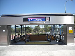
Mirasierra is a station on Line 9 of the Madrid Metro. It is located in fare Zone A.


