Cartography is the study and practice of making maps. Combining science, aesthetics, and technique, cartography builds on the premise that reality can be modeled in ways that communicate spatial information effectively.
A geographic information system (GIS) is a system designed to capture, store, manipulate, analyze, manage, and present spatial or geographic data. GIS applications are tools that allow users to create interactive queries, analyze spatial information, edit data in maps, and present the results of all these operations. GIS sometimes refers to geographic information science (GIScience), the science underlying geographic concepts, applications, and systems.

In modern mapping, a topographic map is a type of map characterized by large-scale detail and quantitative representation of relief, usually using contour lines, but historically using a variety of methods. Traditional definitions require a topographic map to show both natural and man-made features. A topographic survey is typically published as a map series, made up of two or more map sheets that combine to form the whole map. A contour line is a line connecting places of equal elevation.

A digital elevation model (DEM) is a 3D CG representation of a terrain's surface – commonly of a planet, moon, or asteroid – created from a terrain's elevation data. A "global DEM" refers to a Discrete Global Grid.

Topography is the study of the shape and features of land surfaces. The topography of an area could refer to the surface shapes and features themselves, or a description.
A GIS file format is a standard of encoding geographical information into a computer file. They are created mainly by government mapping agencies or by GIS software developers.
The National Topographic System or NTS is the system used by Natural Resources Canada for providing general purpose topographic maps of the country. NTS maps are available in a variety of scales, the standard being 1/50,000 and 1/250,000 scales. The maps provide details on landforms and terrain, lakes and rivers, forested areas, administrative zones, populated areas, roads and railways, as well as other man-made features. These maps are currently used by all levels of government and industry for forest fire and flood control, depiction of crop areas, right-of-way, real estate planning, development of natural resources and highway planning.

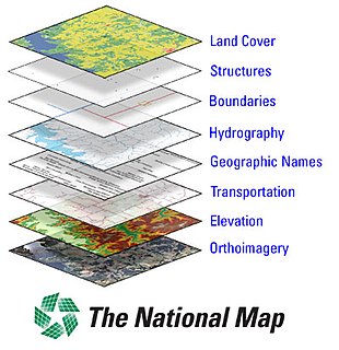
The National Map is a collaborative effort of the United States Geological Survey (USGS) and other federal, state, and local agencies to improve and deliver topographic information for the United States. The purpose of the effort is to provide "...a seamless, continuously maintained set of public domain geographic base information that will serve as a foundation for integrating, sharing, and using other data easily and consistently".

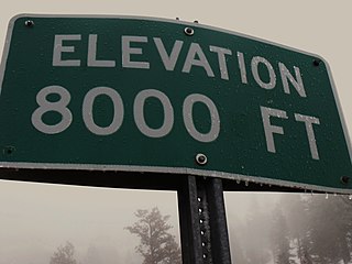
The elevation of a geographic location is its height above or below a fixed reference point, most commonly a reference geoid, a mathematical model of the Earth's sea level as an equipotential gravitational surface .
The term elevation is mainly used when referring to points on the Earth's surface, while altitude or geopotential height is used for points above the surface, such as an aircraft in flight or a spacecraft in orbit, and depth is used for points below the surface.

The Survey of India is India's central engineering agency in charge of mapping and surveying. Set up in 1767 to help consolidate the territories of the British East India Company, it is one of the oldest Engineering Departments of the Government of India. Its members are from Survey of India Service cadre of Civil Services of India and Army Officers from the Corps of Engineers. It is headed by the Surveyor General of India.At present, Survey of India is headed by Lt Gen Girish Kumar, VSM.

ArcGIS is a geographic information system (GIS) for working with maps and geographic information. It is used for creating and using maps, compiling geographic data, analyzing mapped information, sharing and discovering geographic information, using maps and geographic information in a range of applications, and managing geographic information in a database.

Norge 1:50 000 is the main series of 727 topographical maps in 1:50,000 scale that cover the entire mainland area of Norway and proximate islands. The civilian designation is Norway 1:50 000 and the military designation is M711.
Spatial ETL, also known as Geospatial Transformation and Load (GTL), provides the data processing functionality of traditional Extract, Transform, Load (ETL) software, but with a primary focus on the ability to manage spatial data.

Web mapping is the process of using the maps delivered by geographic information systems (GIS) in World Wide Web. A web map on the World Wide Web is both served and consumed, thus web mapping is more than just web cartography, it is a service by which consumers may choose what the map will show. Web GIS emphasizes geodata processing aspects more involved with design aspects such as data acquisition and server software architecture such as data storage and algorithms, than it does the end-user reports themselves.

Ordnance Survey (OS) is the national mapping agency of the United Kingdom which covers the island of Great Britain. Since 1 April 2015 part of Ordnance Survey has operated as Ordnance Survey Ltd, a government-owned company, 100% in public ownership. The Ordnance Survey Board remains accountable to the Secretary of State for Business, Energy and Industrial Strategy. It is also a member of the Public Data Group.

The United States Geological Survey is a scientific agency of the United States government. The scientists of the USGS study the landscape of the United States, its natural resources, and the natural hazards that threaten it. The organization has four major science disciplines, concerning biology, geography, geology, and hydrology. The USGS is a fact-finding research organization with no regulatory responsibility.

A Digital Line Graph (DLG) is a cartographic map feature represented in digital vector form that is distributed by the U.S. Geological Survey (USGS). DLGs are collected from USGS maps and are distributed in large-, intermediate- and small-scale with up to nine different categories of features, depending on the scale. They come in optional and Spatial Data Transfer Standard (SDTS) format and are topologically structured for use in mapping and geographic information system (GIS) applications.
The Military Geographic Service is a unit of the Bulgarian Armed Forces responsible for meeting the obligations of the Bulgarian Ministry of Defense in the field of cartography and geographic information. This includes the mapping and production of topographic maps of 1:25000 and lesser scale, maintaining the national geodetic network, and providing topographic and geographic data, digital products and information to the Armed Forces, government institutions and private users. According to the 2006 Law of Geodesy and Cartography, the areas subject to such mapping comprise the country’s territory as well as the area of the Bulgarian base in Antarctica.

A map collection is a storage facility for maps, usually in a library, archive, or museum, or at a map publisher or public-benefit corporation, and the maps and other cartographic items stored within that facility.


