Related Research Articles
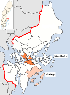
Haninge Municipality is a municipality in Stockholm County in east central Sweden. Its seat is located in Handen, a part of the Stockholm urban area.

Strömstad Municipality is a municipality in Västra Götaland County in western Sweden. Its seat is located in the city of Strömstad.

Hässleholm Municipality is a municipality in Skåne County in southern Sweden. Its seat is located in the city Hässleholm.

Klippan Municipality is a municipality in Skåne County in southern Sweden. Its seat is located in the town of Klippan.

Perstorp Municipality is a municipality in Skåne County in southern Sweden. Its seat is located in the town Perstorp.

Åstorp Municipality is a municipality in Skåne County in South Sweden in southern Sweden. Its seat is located in the town of Åstorp.

Karlshamn Municipality is a municipality in Blekinge County in South Sweden in southern Sweden. It borders to Olofström Municipality, Sölvesborg Municipality, Ronneby Municipality and Tingsryd Municipality. The city of Karlshamn is the seat of the municipality.
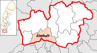
Älmhult Municipality is a municipality in central Kronoberg County in southern Sweden, where the town of Älmhult is seat.

Kumla Municipality is a municipality in Örebro County in central Sweden. Its seat is located in the city of Kumla.
Handen is a part of Metropolitan Stockholm, and the seat of Haninge Municipality in Stockholm County in eastern Sweden. It had 11,524 inhabitants in 2003. Geographically and statistically Handen is a part of Stockholm urban area.

Götavirke are the remains of two parallel defensive walls going from north to south between the villages of Västra Husby and Hylinge in Söderköping Municipality, Östergötland, Sweden. The walls cover the distance between the lakes Asplången and Lillsjön. North of Asplången there are remains of several ancient hill forts that may have been part of the defensive line. South of Lake Lillsjön, the terrain is so hard to pass that it hardly needed any defenses.

The European route E 22 is one of the longest European routes. It has a length of about 5,320 km (3,310 mi). Many of the E-roads have been extended into Asia since the year 2000; the E 22 was extended on 24 June 2002.

Korsze is a town in Kętrzyn County, Warmian-Masurian Voivodeship, Poland, with 4,724 inhabitants (2004). It is a railroad junction, located along the major Olsztyn - Skandawa - line, and Ełk-Bartoszyce line.
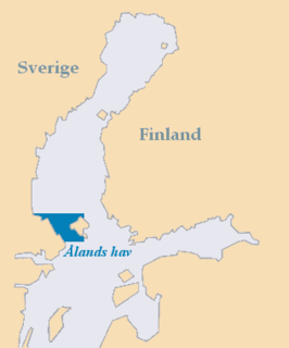
The Sea of Åland is a waterway in the southern Gulf of Bothnia, between the Åland islands and Sweden. It connects the Bothnian Sea with the Baltic Sea proper. The seas are often choppy here. The narrowest part is named South Kvarken. The trench running on the bottom of the Sea of Åland contains the second-deepest spot of the Baltic Sea, at a depth of 301 meters, which is second only to Landsort Deep.
Quế Võ is a rural district of Bắc Ninh Province in the Red River Delta region of Vietnam. As of 2003, the district had a population of 154,694. The district covers an area of 171 km². The district capital lies at Phố Mới.
The Findlay Group is a group of islands in the Canadian Arctic Archipelago in Qikiqtaaluk Region, Nunavut. This Arctic Ocean group consists of Lougheed Island, Stupart Island, Edmund Walker Island, Grosvenor Island and Patterson Island.

Cư Lễ is a commune (xã) and village in Na Rì District, Bắc Kạn Province, in Vietnam.

Mieån is a river in Blekinge County and Kronoberg County, Sweden, which it flows south, into the Baltic Sea in the city of Karlshamn.

Blekinge archipelago is an archipelago in the Baltic Sea, located in Blekinge in the south of Sweden.
References
- ↑ "Län och huvudavrinningsområden i Sverige" (PDF) (in Swedish). Swedish Meteorological and Hydrological Institute . Retrieved 15 July 2010.
Coordinates: 56°10′N15°08′E / 56.167°N 15.133°E

A geographic coordinate system is a coordinate system that enables every location on Earth to be specified by a set of numbers, letters or symbols. The coordinates are often chosen such that one of the numbers represents a vertical position and two or three of the numbers represent a horizontal position; alternatively, a geographic position may be expressed in a combined three-dimensional Cartesian vector. A common choice of coordinates is latitude, longitude and elevation. To specify a location on a plane requires a map projection.
| This article related to a river in Sweden is a stub. You can help Wikipedia by expanding it. |