Roanoke is an independent city in the Commonwealth of Virginia in the United States. It is located in Southwest Virginia along the Roanoke River, in the Blue Ridge range of the greater Appalachian Mountains. Roanoke is approximately 50 miles (80 km) north of the Virginia–North Carolina border and 250 miles (400 km) southwest of Washington, D.C., along Interstate 81. At the 2020 census, Roanoke's population was 100,011, making it the most-populous city in Virginia west of the state capital Richmond. It is the primary population center of the Roanoke metropolitan area, which had a population of 315,251 in 2020.

Salem is an independent city in the U.S. commonwealth of Virginia. As of the 2020 census, the population was 25,346. It is the county seat of Roanoke County, although the two are separate jurisdictions. The Bureau of Economic Analysis combines the city of Salem with Roanoke County, which surrounds both Salem and the neighboring City of Roanoke, for statistical purposes. Salem has its own courthouse and sheriff's office, but shares a jail with Roanoke County, which is located in the Roanoke County Courthouse complex in Salem. The Roanoke County Sheriff's Office and Roanoke County Department of Social Services are also located within Salem, though the county administrative offices are located in unincorporated Cave Spring.

Martinsville is an independent city in the Commonwealth of Virginia in the United States. As of the 2020 census, the population was 13,485. A community of both Southside and Southwest Virginia, it is the county seat of Henry County, although the two are separate jurisdictions. The Bureau of Economic Analysis combines the city of Martinsville with Henry County for statistical purposes.

Henry County is a county located in the U.S. state of Virginia. As of the 2020 census, the population was 50,948. The county seat is usually identified as Martinsville; however, the administration building, county courthouse, and Henry County Sheriff's Office are located on Kings Mountain Road in Collinsville.The Henry County Adult Detention Center is located on DuPont Road in Henry County, just south of Martinsville.

Franklin County is a county located in the Blue Ridge foothills of the Commonwealth of Virginia. As of the 2020 census, the population was 54,477. Its county seat is Rocky Mount. Franklin County is part of the Roanoke Metropolitan Statistical Area and is located in the Roanoke Region of Virginia. The Roanoke River forms its northeast boundary with Bedford County.

Colonial Heights is an independent city in the Commonwealth of Virginia. As of the 2020 census, the population was 18,170. The Bureau of Economic Analysis combines the City of Colonial Heights with Dinwiddie County for statistical purposes.

Halifax County is a county located in the U.S. state of North Carolina. As of the 2020 census, the population was 48,622. Its county seat is Halifax.

Brookneal is an incorporated town in Campbell County, Virginia, United States. The population was 1,090 as of the 2020 census. It is part of the Lynchburg Metropolitan Statistical Area.

John Randolph, commonly known as John Randolph of Roanoke, was an American planter, and a politician from Virginia, serving in the House of Representatives at various times between 1799 and 1833, and the Senate from 1825 to 1827. He was also Minister to Russia under Andrew Jackson in 1830. After serving as President Thomas Jefferson's spokesman in the House, he broke with the president in 1805 as a result of what he saw as the dilution of traditional Jeffersonian principles as well as perceived mistreatment during the impeachment of Samuel Chase, in which Randolph served as chief prosecutor. Following this split, Randolph proclaimed himself the leader of the "Old Republicans" or "Tertium Quids", a wing of the Democratic-Republican Party who wanted to restrict the role of the federal government. Specifically, Randolph promoted the Principles of '98, which said that individual states could judge the constitutionality of central government laws and decrees, and could refuse to enforce laws deemed unconstitutional.

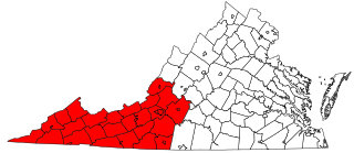
Southwest Virginia, often abbreviated as SWVA, is a mountainous region of Virginia in the westernmost part of the commonwealth. Located within the broader region of western Virginia, Southwest Virginia has been defined alternatively as all Virginia counties on the Appalachian Plateau, all Virginia counties west of the Eastern Continental Divide, or at its greatest expanse, as far east as Blacksburg and Roanoke. Another geographic categorization of the region places it as those counties within the Tennessee River watershed. Regardless of how borders are drawn, Southwest Virginia differs from the rest of the commonwealth in that its culture is more closely associated with Appalachia than the other regions of Virginia. Historically, the region has been and remains a rural area, but in the 20th century, coal mining became an important part of its economy. With the decline in the number of coal jobs and the decline of tobacco as a cash crop, Southwest Virginia is increasingly turning to tourism as a source of economic development. Collectively, Southwest Virginia's craft, music, agritourism and outdoor recreation are referred to as the region's "creative economy."

George Steven Agee is a United States circuit judge of the United States Court of Appeals for the Fourth Circuit and a former justice of the Supreme Court of Virginia.

Henry Alonzo Edmundson was a 19th-century Virginia lawyer, congressman, farmer, slaveowner and Confederate officer. He served six terms in the U.S. House of Representatives from 1849 to 1861.
South Washington Heights is a neighborhood in Roanoke, Virginia, located in far western Roanoke. It borders the neighborhoods of Washington Heights and Villa Heights on the north, Wilmont on the south, Shenandoah West on the east and Edgewood-Summit Hills on the west. The neighborhood fronts U.S. Highway 460 along its entire northern boundary.
Fairland is a Roanoke, Virginia neighborhood located in north, central Roanoke across Interstate 581, opposite Valley View Mall. It borders the neighborhoods of Miller Court/Arrowood and Villa Heights on the west and Roundhill and Melrose-Rugby on the east. As of the 2000 U.S. Census, Fairland has a population of 1,492 residents.
Villa Heights is a Roanoke, Virginia neighborhood located in northwest Roanoke north of U.S. 460. It borders the neighborhoods of Washington Heights on the west, Melrose-Rugby on the east, Fairland, Miller Court/Arrowood and Westview Terrace on the north and Shenandoah West and South Washington Heights on the south. As of the 2000 U.S. Census, Villa Heights has a population of 2,840 residents.
Shenandoah West is a Roanoke, Virginia neighborhood located in west Roanoke south of U.S. 460. It borders the neighborhoods of South Washington Heights, Wilmont and Cherry Hill on the west, Loudon-Melrose on the east, Villa Heights on the north and Hurt Park on the south opposite the Norfolk Southern rail yard.

The 1984 United States presidential election in Virginia took place on November 6, 1984. All 50 states and the District of Columbia, were part of the 1984 United States presidential election. Virginia voters chose 12 electors to the Electoral College, which selected the president and vice president of the United States.
Elijah McClanahan was a planter and soldier in western Virginia and the Roanoke Valley. He was a Lieutenant Colonel in the 5th/121st Virginia Militia in the War of 1812, and was one of the largest landholders in what later became Roanoke County, Virginia.

The Villa Heights house, also known as the Compton–Bateman House, is a historic house in Roanoke, Virginia, USA. Built in 1820, it was originally the home of Elijah McClanahan, a lieutenant-colonel in the War of 1812. It has been substantially renovated and restored over the years, including after a 2011 fire, and it is the namesake of the neighborhood of Villa Heights, Roanoke, Virginia. It was added to the National Register of Historic Places in 2018, and as of 2023 houses assorted non-profit groups.


