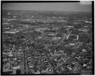
Georgetown is a historic neighborhood and a commercial and entertainment district located in northwest Washington, D.C., situated along the Potomac River. Founded in 1751 in the Province of Maryland, the port of Georgetown predated the establishment of the federal district and the City of Washington by 40 years. Georgetown remained a separate municipality until 1871, when the United States Congress created a new consolidated government for the whole District of Columbia. A separate act passed in 1895 specifically repealed Georgetown's remaining local ordinances and renamed Georgetown's streets to conform with those in the City of Washington.

Dupont Circle is a traffic circle, park, neighborhood, and historic district in Northwest Washington, D.C.. The Dupont Circle neighborhood is bounded approximately by 16th Street NW to the east, 22nd Street NW to the west, M Street NW to the south, and Florida Avenue NW to the north. Much of the neighborhood is listed on the National Register of Historic Places. However, the local government Advisory Neighborhood Commission and the Dupont Circle Historic District have slightly different boundaries.
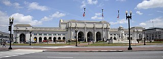
Washington Union Station is a major train station, transportation hub, and leisure destination in Washington, D.C. Opened in 1907, it is Amtrak's headquarters and the railroad's second-busiest station with annual ridership of just under 5 million and the ninth-busiest in overall passengers served in the United States. The station is the southern terminus of the Northeast Corridor, an electrified rail line extending north through major cities including Baltimore, Philadelphia, New York City, and Boston and the busiest passenger rail line in the nation.
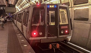
The Blue Line is a rapid transit line of the Washington Metro system, consisting of 27 stations in Fairfax County, Alexandria and Arlington, Virginia; the District of Columbia; and Prince George's County, Maryland, United States. The Blue Line runs from Franconia–Springfield to Largo Town Center. The line shares tracks with the Orange Line for 13 stations, the Silver Line for 18, and the Yellow Line for six. Only three stations are exclusive to the Blue Line.

The Orange Line is a rapid transit line of the Washington Metro system, consisting of 26 stations in Fairfax County and Arlington, Virginia; the District of Columbia; and Prince George's County, Maryland, United States. The Orange Line runs from Vienna in Virginia to New Carrollton in Maryland. Half of the line's stations are shared with the Blue Line and over two thirds are shared with the Silver Line. Orange Line service began on November 20, 1978.

The Red Line is a rapid transit line of the Washington Metro system, consisting of 27 stations in Montgomery County, Maryland, and Washington, D.C., in the United States. It is a primary line through downtown Washington and the oldest, busiest, and longest line in the system. It forms a long, narrow "U", capped by its terminal stations at Shady Grove and Glenmont.

The Yellow Line is a rapid transit line of the Washington Metro system, consisting of 17 stations in Fairfax County, Alexandria, and Arlington County, Virginia, as well as Washington, D.C.. The Yellow Line runs from Huntington in Virginia to Greenbelt station during all times since May 2019. Before then, it used to short turns at Mount Vernon Square during peak hours and ended at Fort Totten station during off-peak hours.

Pentagon City is a side-platformed Washington Metro station in the Pentagon City neighborhood of Arlington, Virginia, United States. The station was opened on July 1, 1977, and is operated by the Washington Metropolitan Area Transit Authority (WMATA). Providing service for both the Blue and Yellow Lines, the station is located at the corner of Hayes Street and 12th Street, between Army-Navy Drive and South 15th Street. It links to a tunnel that allows direct access west into the Fashion Centre at Pentagon City, a large shopping mall, and east under Hayes Street to an entrance outside the Pentagon Centre shopping complex.

L'Enfant Plaza is an intermodal transit station located at L'Enfant Plaza in the Southwest Federal Center neighborhood of Washington, DC. It consists of an underground Washington Metro rapid transit station and an elevated Virginia Railway Express commuter rail station.
The Rock Creek and Potomac Parkway, often known simply as the Rock Creek Parkway, is a parkway maintained by the National Park Service as part of Rock Creek Park in Washington, D.C. It runs next to the Potomac River and Rock Creek in a generally north–south direction, carrying four lanes of traffic from the Lincoln Memorial and Arlington Memorial Bridge north to a junction with Beach Drive near Connecticut Avenue at Calvert Street, N.W., just south of the National Zoological Park.
Trinidad is a neighborhood located in Ward 5, in the northeast quadrant of Washington, D.C. and is a largely residential area.

14th Street NW/SW is a street in Northwest and Southwest quadrants of Washington, D.C., located 1.25 miles (2.01 km) west of the U.S. Capitol. It runs from the 14th Street Bridge north to Eastern Avenue.
U.S. Route 1 within the District of Columbia passes between Arlington, Virginia and Mount Rainier, Maryland predominantly along surface streets. However, it forms a few overlaps with other routes.
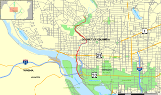
U.S. Route 29 (US 29) in the District of Columbia is a U.S. highway which enters D.C. via Key Bridge from Arlington, Virginia, and exits at Silver Spring, Maryland. It predominantly follows city surface streets, although the portion of the route from Key Bridge east to 26th Street NW is an elevated highway. The elevated section of U.S. Route 29 in D.C. is better known as the Whitehurst Freeway. Called the city's most ridiculed bridge in 1989, there have been several attempts to have the Whitehurst Freeway torn down but cost and other considerations have stopped these proposals from being acted on.

The First Street Tunnel is a two-track, soft-earth tunnel built between 1904 and 1906 by the Washington Terminal Company to serve as the southern approach to Union Station in Washington, D.C. Currently owned by Amtrak, it connects to lower-level tracks and platforms at the station, passes under Capitol Hill and connects to the RF&P Subdivision and Long Bridge, offering through railway service to Alexandria, Virginia, and points west and south. Unlike the Northeast Corridor tracks north of Union Station, the tunnel tracks are not electrified, so southbound trains leaving Union Station must switch to diesel locomotives before entering the tunnel. Exiting Union Station, the tunnel runs due south under First Street NE and SE before curving to the southwest under a parking lot near the Capitol South Metro station. Its southern portal is just east of South Capitol Street at the intersection of D Street SE and New Jersey Avenue SE.

The Capitol Reflecting Pool is a reflecting pool in Washington, D.C., USA. It lies to the west of the United States Capitol and is the westernmost element of the Capitol grounds. The Capitol Dome and the Ulysses S. Grant Memorial are reflected in its waters.
The RF&P Subdivision is a railroad line owned and operated by CSX Transportation. It runs from Washington, D.C. to Richmond, Virginia, over lines previously owned by the Pennsylvania Railroad and the Richmond, Fredericksburg and Potomac Railroad. The line's name pays homage to that railroad, which was a predecessor to the CSX.