This page is based on this
Wikipedia article Text is available under the
CC BY-SA 4.0 license; additional terms may apply.
Images, videos and audio are available under their respective licenses.

State Route 70 is a primary state highway in Lee County, Virginia, running from the Tennessee state line to U.S. Route 58 in Jonesville. Its continuation in Tennessee, also numbered State Route 70, continues south to the North Carolina state line at North Carolina Highway 208.
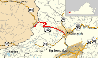
State Route 160 is a primary state highway in the U.S. state of Virginia. Known as the Trail of the Lonesome Pine, the state highway runs 8.02 miles (12.91 km) from the Kentucky state line on top of Black Mountain, where the highway continues north as Kentucky Route 160, east to SR 68 in Appalachia.
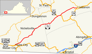
State Route 71 is a primary state highway in the southwest part of the U.S. state of Virginia. It runs from Gate City northeast to Lebanon, mostly through river valleys. Despite running more east–west than north–south, it is signed north–south; it parallels the similarly-oriented U.S. Route 11 and Interstate 81.

State Route 89 is a primary state highway in the U.S. state of Virginia. The state highway runs 7.85 miles (12.63 km) from the North Carolina state line, where the highway continues as North Carolina Highway 89, north to U.S. Route 58 and US 221 in Galax.

State Route 75 is a primary state highway in the southwest part of the U.S. state of Virginia, running southwest from U.S. Route 11 and U.S. Route 58 Alternate in Abingdon to Tennessee's State Route 44.

State Route 67 is a primary state highway in the southwest part of the U.S. state of Virginia. It runs from State Route 80 near Honaker east to U.S. Route 460 at Raven, east concurrently with US 460 and U.S. Route 460 Business into downtown Richlands, and north to State Route 616 at Jewell Ridge on the Tazewell–Buchanan county line.

State Route 16 is a primary state highway in the southwest part of the U.S. state of Virginia. It runs from the North Carolina border at North Carolina Highway 16 north to the West Virginia border at West Virginia Route 16, passing through the towns of Troutdale, Marion, and Tazewell.

State Route 96 is a primary state highway in the U.S. state of Virginia. Known for most of its length as Virgilina Road, the state highway runs 7.83 miles (12.60 km) from U.S. Route 501 near Cluster Springs east to the North Carolina state line in Virgilina. In Virgilina, SR 96 runs concurrently with SR 49 south to the border, where the highways continue as North Carolina Highway 96 and NC 49, respectively.

State Route 84 is a primary state highway in the U.S. state of Virginia. Known as Mill Gap Road, the state highway runs 14.94 miles (24.04 km) from the West Virginia state line near Mill Gap, where the highway continues west as West Virginia Route 84, east to U.S. Route 220 at Vanderpool.

State Route 13 is a primary state highway in the U.S. state of Virginia. Known as Old Buckingham Road, the state highway runs 24.08 miles (38.75 km) from U.S. Route 60 and SR 45 in Cumberland east to US 60 in Plain View. SR 13 parallels US 60 to the south through eastern Cumberland County and western Powhatan County and passes through the latter county's seat of Powhatan. The state highway is the only state-numbered highway in Virginia that shares a number with a U.S. Highway but does not form a state-numbered extension of that U.S. Highway. SR 13's number comes from being a segment of the original cross-state SR 13 in 1918; that highway included portions of modern US 60. In 1933, US 60 was shifted to its present corridor between Buena Vista and Richmond, replacing SR 13. Two years later, SR 13 was assigned to Old Buckingham Road when US 60 was moved to its present alignment from Cumberland to east of Powhatan.

State Route 271 is a primary state highway in the U.S. state of Virginia. Known as Pouncey Tract Road, the state highway runs 7.34 miles (11.81 km) from U.S. Route 250 in Short Pump north to SR 620 and SR 622 in Rockville. A small section of it was first added to the state highway system as State Route 431 in 1930. By 1940, it had gained its current routing and designation.
