
A geographic information system (GIS) is a type of database containing geographic data, combined with software tools for managing, analyzing, and visualizing those data. In a broader sense, one may consider such a system to also include human users and support staff, procedures and workflows, body of knowledge of relevant concepts and methods, and institutional organizations.

Geomatics is defined in the ISO/TC 211 series of standards as the "discipline concerned with the collection, distribution, storage, analysis, processing, presentation of geographic data or geographic information". Under another definition, it consists of products, services and tools involved in the collection, integration and management of geographic (geospatial) data. It is also known as geomatic(s) engineering. Surveying engineering was the widely used name for geomatic(s) engineering in the past.
The EASTInitiative is an educational non-profit that oversees and trains for a school program, EAST, that operates primarily in the United States.
A GIS software program is a computer program to support the use of a geographic information system, providing the ability to create, store, manage, query, analyze, and visualize geographic data, that is, data representing phenomena for which location is important. The GIS software industry encompasses a broad range of commercial and open-source products that provide some or all of these capabilities within various information technology architectures.

ArcGIS is a family of client software, server software, and online geographic information system (GIS) services developed and maintained by Esri. ArcGIS was first released in 1999 and originally was released as ARC/INFO, a command line based GIS system for manipulating data. ARC/INFO was later merged into ArcGIS Desktop, which was eventually superseded by ArcGIS Pro in 2015. ArcGIS Pro works in 2D and 3D for cartography and visualization, and includes Artificial Intelligence (AI).
Geovisualization or geovisualisation, also known as cartographic visualization, refers to a set of tools and techniques supporting the analysis of geospatial data through the use of interactive visualization.
The Open Source Geospatial Foundation (OSGeo), is a non-profit non-governmental organization whose mission is to support and promote the collaborative development of open geospatial technologies and data. The foundation was formed in February 2006 to provide financial, organizational and legal support to the broader Free and open-source geospatial community. It also serves as an independent legal entity to which community members can contribute code, funding and other resources.
Time geography or time-space geography is an evolving transdisciplinary perspective on spatial and temporal processes and events such as social interaction, ecological interaction, social and environmental change, and biographies of individuals. Time geography "is not a subject area per se", but rather an integrative ontological framework and visual language in which space and time are basic dimensions of analysis of dynamic processes. Time geography was originally developed by human geographers, but today it is applied in multiple fields related to transportation, regional planning, geography, anthropology, time-use research, ecology, environmental science, and public health. According to Swedish geographer Bo Lenntorp: "It is a basic approach, and every researcher can connect it to theoretical considerations in her or his own way."
Digital Earth is the name given to a concept by former US vice president Al Gore in 1998, describing a virtual representation of the Earth that is georeferenced and connected to the world's digital knowledge archives.
Participatory GIS (PGIS) or public participation geographic information system (PPGIS) is a participatory approach to spatial planning and spatial information and communications management.
The GeoNetwork opensource (GNOS) project is a free and open source (FOSS) cataloging application for spatially referenced resources. It is a catalog of location-oriented information.
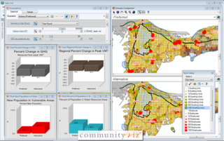
CommunityViz is the name of a group of extensions to ArcGIS Geographic Information System software. CommunityViz is an analysis tool used for, among other applications, urban planning, land use planning, geodesign, transportation planning and resource management applications. It also provides options for 3D visualization in the Scenario 3D and Scenario 360 plugins. CommunityViz also allows users to export and view their work in ArcGIS Online, Google Earth and other KML/KMZ viewers such as ArcGIS Explorer. The software was originally produced by the Orton Family Foundation and in 2005 was handed off to Placeways LLC. In 2017, the software was purchased by City Explained, Inc. where its development continues.
Collaborative mapping is the aggregation of Web mapping and user-generated content, from a group of individuals or entities, and can take several distinct forms. With the growth of technology for storing and sharing maps, collaborative maps have become competitors to commercial services, in the case of OpenStreetMap, or components of them, as in Google Map Maker and Yandex.Map editor.

A 3D city model is digital model of urban areas that represent terrain surfaces, sites, buildings, vegetation, infrastructure and landscape elements in three-dimensional scale as well as related objects belonging to urban areas. Their components are described and represented by corresponding two- and three-dimensional spatial data and geo-referenced data. 3D city models support presentation, exploration, analysis, and management tasks in a large number of different application domains. In particular, 3D city models allow "for visually integrating heterogeneous geoinformation within a single framework and, therefore, create and manage complex urban information spaces."
Geodesign is a set of concepts and methods used to involve all stakeholders and various professions in collaboratively designing and realizing the optimal solution for spatial challenges in the built and natural environments, utilizing all available techniques and data in an integrated process. Originally, geodesign was mainly applied during the design and planning phase. "Geodesign is a design and planning method which tightly couples the creation of design proposals with impact simulations informed by geographic contexts." Now, it is also used during realization and maintenance phases and to facilitate re-use of for example buildings or industrial areas. Geodesign includes project conceptualization, analysis, design specification, stakeholder participation and collaboration, design creation, simulation, and evaluation.

ArcGIS CityEngine is a commercial three-dimensional (3D) modeling software application developed by Esri R&D Center Zurich and specialises in the generation of 3D urban environments. Using a procedural modeling approach, it supports the creation of detailed large-scale 3D city models. CityEngine works with architectural object placement and arrangement in the same manner that software like VUE manages terrain, ecosystems and atmosphere mapping. Unlike the traditional 3D modeling methodology which uses Computer-Aided Design (CAD) tools and techniques, CityEngine takes a different approach to shape generation via a rule-based system. It can also use Geographic Information System (GIS) datasets due to its integration with the wider Esri/ArcGIS platform. Due to this unique feature set, CityEngine has been used in academic research and built environment professions, e.g., urban planning, architecture, visualization, game development, entertainment, archeology, military and cultural heritage. CityEngine can be used within Building Information Model (BIM) workflows as well as visualizing the data of buildings in a larger urban context, enhancing its working scenario toward real construction projects.
GeoTime is geospatial analysis software that allows the visual analysis of events over time. It adds time as the third dimension to a two-dimensional map, allowing users to see changes within time series data. Users can view real-time animated playback of data and use automated analysis tools within the software to identify location patterns, connections between events, and trends.
A medical animation is a short educational film, usually based around a physiological or surgical topic, that is rendered using 3D computer graphics. While it may be intended for an array of audiences, the medical animation is most commonly utilized as an instructional tool for medical professionals or their patients.
Spatial citizenship describes the ability of individuals and groups to interact and participate in societal spatial decision making through the reflexive production and use of geo-media. Spatial citizens are lay users who are able to use geo-media to question existing perspectives on action in space and to produce, communicate, and negotiate alternative spatial visions.

Head/tail breaks is a clustering algorithm scheme for data with a heavy-tailed distribution such as power laws and lognormal distributions. The heavy-tailed distribution can be simply referred to the scaling pattern of far more small things than large ones, or alternatively numerous smallest, a very few largest, and some in between the smallest and largest. The classification is done through dividing things into large and small things around the arithmetic mean or average, and then recursively going on for the division process for the large things or the head until the notion of far more small things than large ones is no longer valid, or with more or less similar things left only. Head/tail breaks is not just for classification, but also for visualization of big data by keeping the head, since the head is self-similar to the whole. Head/tail breaks can be applied not only to vector data such as points, lines and polygons, but also to raster data like digital elevation model (DEM).