Vitozza

Last updated

Coordinates: 42°40′40″N11°45′25″E / 42.67778°N 11.75694°E / 42.67778; 11.75694 Vitozza is a cave settlement located near the village of San Quirico in the municipality of Sorano, in the province of Grosseto, southern Tuscany (Italy), which was inhabited from Etruscan times until the end of the 18th century.

Geographic coordinate system Coordinate system

A geographic coordinate system is a coordinate system that enables every location on Earth to be specified by a set of numbers, letters or symbols. The coordinates are often chosen such that one of the numbers represents a vertical position and two or three of the numbers represent a horizontal position; alternatively, a geographic position may be expressed in a combined three-dimensional Cartesian vector. A common choice of coordinates is latitude, longitude and elevation. To specify a location on a plane requires a map projection.

San Quirico, Sorano Frazione in Tuscany, Italy

San Quirico is a village in Tuscany, central Italy, administratively a frazione of the comune of Sorano, province of Grosseto, in the tuff area of southern Maremma. At the time of the 2001 census its population amounted to 572.

Sorano Comune in Tuscany, Italy

Sorano is a town and comune in the province of Grosseto, southern Tuscany (Italy).

Contents

History

The first castle of Vitozza Primo Castello di Vitozza (GR).jpg
The first castle of Vitozza

The ancient city of Vitozza was built in the medieval era, most likely at the end of the 11th century, around a castle built by the Aldobrandeschi family within a cave settlement which was most likely already inhabited during Etruscan and Roman times.

Castle Fortified residential structure of medieval Europe

A castle is a type of fortified structure built during the Middle Ages by predominantly the nobility or royalty and by military orders. Scholars debate the scope of the word castle, but usually consider it to be the private fortified residence of a lord or noble. This is distinct from a palace, which is not fortified; from a fortress, which was not always a residence for royalty or nobility; and from a fortified settlement, which was a public defence – though there are many similarities among these types of construction. Usage of the term has varied over time and has been applied to structures as diverse as hill forts and country houses. Over the approximately 900 years that castles were built, they took on a great many forms with many different features, although some, such as curtain walls and arrowslits, were commonplace.

Aldobrandeschi family noble family

The Aldobrandeschi were an Italian noble family from southern Tuscany.

Etruscan civilization Pre-Roman civilization of ancient Italy

The Etruscan civilization is the modern name given to a powerful and wealthy civilization of ancient Italy in the area corresponding roughly to Tuscany, south of the Arno river, western Umbria, northern and central Lazio, with offshoots also to the north in the Po Valley, in the current Emilia-Romagna, south-eastern Lombardy and southern Veneto, and to the south, in some areas of Campania. As distinguished by its unique language, this civilization endured from before the time of the earliest Etruscan inscriptions until its assimilation into the Roman Republic, beginning in the late 4th century BC with the Roman–Etruscan Wars.

In the first half of the 13th century, Vitozza passed temporarily under the control of Orvieto and then the Basque family, before being taken up again by the Aldobrandeschi and included into the territory of County of Sovana in 1274, the year of the division of family assets.

Orvieto Comune in Umbria, Italy

Orvieto is a city and comune in the Province of Terni, southwestern Umbria, Italy situated on the flat summit of a large butte of volcanic tuff. The city rises dramatically above the almost-vertical faces of tuff cliffs that are completed by defensive walls built of the same stone called Tufa.

Between the end of the 13th and the early 14th century, the place was conquered by the Republic of Siena under which it stayed until the middle of the 15th century. Subsequently, Vitozza became part of County Orsini, but later there was a move away from the castle and its defensive structures for reasons yet unknown, causing the decline of the settlement. The population gradually migrated towards the nearby town of San Quirico, however, Vitozza was inhabited until the end of the 18th century.

Republic of Siena former republic on the Apennine Peninsula between 1125 and 1555

The Republic of Siena was a historic state consisting of the city of Siena and its surrounding territory in Tuscany, central Italy. It existed for over four hundred years, from 1125 to 1555. In the Italian War of 1551–59 the republic was defeated by the rival Duchy of Florence in alliance with the Spanish crown. After 18 months of resistance, the Republic of Siena surrendered to the Spanish Empire on 21 April 1555, marking the end of the republic.

Archaeological Area

In the Middle Ages, Vitozza had a fortified castle, at least two fortresses, and places of worship including a major and two minor churches, in addition to the cave settlement.

Church (building) building constructed for Christian worship

A church building or church house, often simply called a church, is a building used for Christian religious activities, particularly for Christian worship services. The term is often used by Christians to refer to the physical buildings where they worship, but it is sometimes used to refer to buildings of other religions. In traditional Christian architecture, the church is often arranged in the shape of a Christian cross. When viewed from plan view the longest part of a cross is represented by the aisle and the junction of the cross is located at the altar area.

Settlement

Detail of a residential cave Insediamento rupestre di Vitozza (GR)4.jpg
Detail of a residential cave

The cave settlement of Vitozza is certainly the largest and most important of central Italy. It includes over two hundred caves excavated from the local tuff stone.

Tuff Rock consolidated from volcanic ash

Tuff, also known as volcanic tuff, is a type of rock made of volcanic ash ejected from a vent during a volcanic eruption. Following ejection and deposition, the ash is compacted into a solid rock in a process called consolidation. Tuff is sometimes erroneously called "tufa", particularly when used as construction material, but properly speaking, tufa is a limestone precipitated from groundwater. Rock that contains greater than 50% tuff is considered tuffaceous.

The caves used for human habitation extend along a path through the woods overlooking the valley of the river Lente. Some are quite close to each other, while others tend to be more isolated.

Depending on their type, caves can in fact be classified in four different types:

The first group is characterized by tunnels with rectangular openings which are often on different levels, connected by ladders and steps, with houses located on the upper levels and animal shelters in the lower ones.

A second group of caves presents rectangular structures destined to house the animals.

A third type of caves was for mixed use - they are characterized by an arched opening, a circular area and attached rooms. The circular part, for animal use, was equipped with a feeder, the other rooms were probably used for habitation.

The northwestern part of Vitozza includes a group of dozens of caves known as columbaria which almost certainly were created in Roman times and remained active throughout the Middle Ages for the purpose of pigeon breeding, a common practice in the territory of Sorano.

Fortresses

The Second Castle of Vitozza Secondo Castello di Vitozza (GR).jpg
The Second Castle of Vitozza

The primo castello (first castle) is a fortification located along the path that runs through the entire rock settlement. The fortification is the first of two elevated fortifications or rocche shaping the castle ruins of medieval Vitozza. The structure shows thick walls of blocks of tuff, which would take up a door that opened along the access route. The remains of the fortress are visible on both sides of the path that forks just before. On the north side, the building was surrounded by a moat, now rendered invisible by vegetation, which further protected the defensive structure.

The secondo castello (second castle) is a fortified structure located along the path leading to the columbaria (caves used for rearing poultry) and the source of the river Lente. It is situated on a hill which rises to the right of the path, and is better preserved than the first fortress.

Chiesaccia

The Chiesaccia at Vitozza La Chiesaccia at Vitozza by S F William.JPG
The Chiesaccia at Vitozza

The ruins of a church dating back to the Middle Ages, called The Chiesaccia, is situated to the right of the main path near the primo castello. It has a simple rectangular floor plan and a semicircular apse.

On the northern side of the plateau near the church are the ruins of another defensive building, as well as the remains of a gate that controlled access through the road parallel to the ridge.

Related Research Articles

Pitigliano Comune in Tuscany, Italy

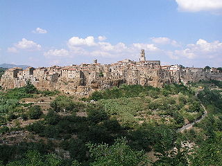
Pitigliano is a town in the province of Grosseto, located about 80 kilometres (50 mi) south-east of the city of Grosseto, Tuscany Italy.

Sovana Frazione in Tuscany, Italy

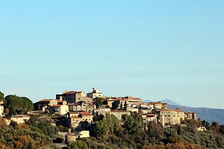
Sovana is a small town in southern Tuscany, Italy, a frazione of Sorano, a comune in the province of Grosseto.

Istia dOmbrone Frazione in Tuscany, Italy

Istia d'Ombrone is a small town in southern Tuscany, Italy, a frazione of the comune of Grosseto.

Giuncarico Frazione in Tuscany, Italy

Giuncarico is a village in Tuscany, central Italy, administratively a frazione of the comune of Gavorrano, province of Grosseto. At the time of the 2001 census its population amounted to 399.

Via cava

The Vie Cave, also known in Italian as Cavoni, is an impressive road network in southern Europe, found in Spain, Italy, Turkey and as far east as Jordan. In Italy they partly link an Etruscan necropolis and several settlements in the area between Sovana, Sorano and Pitigliano. They consist mainly of trenches of variable width and length, excavated as nearly vertical cliffs in different types of bedrock, sometimes over sixty feet high, possibly serving as a defense system against invaders, wild animals or forces of nature. Although often dated as being carved by pre-Roman civilisations in the first or second millennium BC, the builders and purpose of the road system are largely unclear, and there are indications that they are much older than assumed.

Tatti, Massa Marittima Frazione in Tuscany, Italy

Tatti is a village in Tuscany, central Italy, administratively a frazione of the comune of Massa Marittima, province of Grosseto, in the area of the Colline Metallifere. At the time of the 2001 census its population amounted to 231.

Buriano, Castiglione della Pescaia Frazione in Tuscany, Italy

Buriano is a village in Tuscany, central Italy, administratively a frazione of the comune of Castiglione della Pescaia, province of Grosseto. At the time of the 2001 census its population amounted to 257.

CastellOttieri Frazione in Tuscany, Italy

Castell'Ottieri is a village in Tuscany, central Italy, administratively a frazione of the comune of Sorano, province of Grosseto, in the tuff area of southern Maremma. At the time of the 2001 census its population amounted to 195.

Catabbio Frazione in Tuscany, Italy

Catabbio is a village in Tuscany, central Italy, administratively a frazione of the comune of Semproniano, province of Grosseto. At the time of the 2001 census its population amounted to 203.

Elmo, Sorano Frazione in Tuscany, Italy

Elmo is a village in Tuscany, central Italy, administratively a frazione of the comune of Sorano, province of Grosseto, in the tuff area of southern Maremma. At the time of the 2001 census its population amounted to 44.

Marsiliana Frazione in Tuscany, Italy

Marsiliana, known also as Marsiliana d'Albegna, is a village in Tuscany, central Italy, administratively a frazione of the comune of Manciano, province of Grosseto. At the time of the 2001 census its population amounted to 246.

Montebuono, Sorano Frazione in Tuscany, Italy

Montebuono is a village in Tuscany, central Italy, administratively a frazione of the comune of Sorano, province of Grosseto, in the tuff area of southern Maremma. At the time of the 2001 census its population amounted to 37.

Montemerano Frazione in Tuscany, Italy

Montemerano is a village in Tuscany, central Italy, administratively a frazione of the comune of Manciano, province of Grosseto. At the time of the 2001 census its population amounted to 438.

Montevitozzo Frazione in Tuscany, Italy

Montevitozzo is a village in Tuscany, central Italy, administratively a frazione of the comune of Sorano, province of Grosseto, in the tuff area of southern Maremma. At the time of the 2001 census its population amounted to 106.

Montorio, Sorano Frazione in Tuscany, Italy

Montorio is a village in Tuscany, central Italy, administratively a frazione of the comune of Sorano, province of Grosseto, in the tuff area of southern Maremma.

Rocchette di Fazio Frazione in Tuscany, Italy

Rocchette di Fazio is a village in Tuscany, central Italy, administratively a frazione of the comune of Semproniano, province of Grosseto. At the time of the 2001 census its population amounted to 19.

Sasso dOmbrone Frazione in Tuscany, Italy

Sasso d'Ombrone is a village in Tuscany, central Italy, administratively a frazione of the comune of Cinigiano, province of Grosseto. At the time of the 2001 census its population amounted to 300.

San Valentino, Sorano Frazione in Tuscany, Italy

San Valentino is a village in Tuscany, central Italy, administratively a frazione of the comune of Sorano, province of Grosseto, in the tuff area of southern Maremma. At the time of the 2001 census its population was 58.

References