Vía Verde de la Sierra

Last updated
Puerto Serrano station Via verde de la sierra(estacion Puerto Serrano2).JPG
Puerto Serrano station

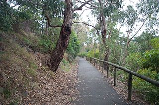
The Vía Verde de la Sierra is a rail trail for tourist use (hiking, cycling and horse riding) comprising 38 km (24 mi) of mountainous landscape between Puerto Serrano and Olvera villages, provinces of Cádiz and Sevilla. It is part of Vías Verdes of Spain (Spanish national rail trail system). [1]

Rail trail railroad bed converted to a recreational trail

A rail trail is the conversion of a disused railway track into a multi-use path, typically for walking, cycling and sometimes horse riding and snowmobiling. The characteristics of abandoned railways—flat, long, frequently running through historical areas—are appealing for various developments. The term sometimes also covers trails running alongside working railways; these are called "rails with trails". Some shared trails are segregated, with the segregation achieved with or without separation. Many rail trails are long-distance trails.

Hiking walking as a hobby, sport, or leisure activity

Hiking is the preferred term, in Canada and the United States, for a long, vigorous walk, usually on trails (footpaths), in the countryside, while the word walking is used for shorter, particularly urban walks. On the other hand, in the United Kingdom, and the Republic of Ireland, the word "walking" is acceptable to describe all forms of walking, whether it is a walk in the park or backpacking in the Alps. The word hiking is also often used in the UK, along with rambling, hillwalking, and fell walking. The term bushwalking is endemic to Australia, having been adopted by the Sydney Bush Walkers club in 1927. In New Zealand a long, vigorous walk or hike is called tramping. It is a popular activity with numerous hiking organizations worldwide, and studies suggest that all forms of walking have health benefits.

Cycling riding a bicycle

Cycling, also called biking or bicycling, is the use of bicycles for transport, recreation, exercise or sport. People engaged in cycling are referred to as "cyclists", "bikers", or less commonly, as "bicyclists". Apart from two-wheeled bicycles, "cycling" also includes the riding of unicycles, tricycles, quadracycles, recumbent and similar human-powered vehicles (HPVs).

Contents

The path goes along the riverside of Guadalete and Guadalporcún, around the nature reserve of Peñón de Zaframagón (where there is a large colony of griffon vultures) and the natural monument of Chaparro de la Vega.

Guadalete river in Spain

The Guadalete River is located almost entirely in the Spanish province of Cádiz, rising in the Sierra de Grazalema Natural Park at an elevation of about 1,000 metres (3,300 ft), and running for 172 kilometres (107 mi) into the Bay of Cádiz at El Puerto de Santa Maria, south of the city of Cádiz. The river's name comes from the Arabic phrase meaning "River of Forgetfulness".

Nature reserve protected area for flora, fauna or features of geological interest

A nature reserve is a protected area of importance for flora, fauna or features of geological or other special interest, which is reserved and managed for conservation and to provide special opportunities for study or research. Nature reserves may be designated by government institutions in some countries, or by private landowners, such as charities and research institutions, regardless of nationality. Nature reserves fall into different IUCN categories depending on the level of protection afforded by local laws. Normally it is more strictly protected than a nature park.

Griffon vulture species of bird

The griffon vulture is a large Old World vulture in the bird of prey family Accipitridae. It is also known as the Eurasian griffon. It is not to be confused with a different species, Rüppell's griffon vulture. It is closely related to the white-backed vulture.

The route uses a rail track between Jerez de la Frontera (Cádiz) and Almargen (Málaga) through the Cádiz mountains.

Jerez de la Frontera Municipality in Andalusia, Spain

Jerez de la Frontera, or simply Jerez, is a Spanish city and municipality in the province of Cádiz in the autonomous community of Andalusia, in southwestern Spain, located midway between the Atlantic Ocean and the Cádiz Mountains. As of 2015, the city, the largest in the province, had a population of 212,876. It is the fifth largest in Andalusia, and has become the transportation and communications hub of the province, surpassing even Cádiz, the provincial capital, in economic activity. Jerez de la Frontera is also, in terms of land area, the largest municipality in the province, and its sprawling outlying areas are a fertile zone for agriculture. There are also many cattle ranches and horse-breeding operations, as well as a world-renowned wine industry (Xerez).

Almargen Municipality in Andalusia, Spain

Almargen is a town and municipality in the province of Málaga, part of the autonomous community of Andalusia in southern Spain. The municipality is situated approximately 105 kilometers from the capital, Málaga. It is 43.7 km from Ronda and 48.2 km from Antequera. It has a population of approximately 2,100 residents. The natives are called Almargeños.

Interesting places

Viaduct over Guadalete river ViaductoViaVerdeSierraCadiz.jpg
Viaduct over Guadalete river

Some interesting places near the road are:

Natural monument natural or natural/cultural feature of outstanding or unique value

A natural monument is a natural or natural/cultural feature of outstanding or unique value because of its inherent rarity, representative of aesthetic qualities or cultural significance.

Spain Kingdom in Southwest Europe

Spain, officially the Kingdom of Spain, is a country mostly located in Europe. Its continental European territory is situated on the Iberian Peninsula. Its territory also includes two archipelagoes: the Canary Islands off the coast of Africa, and the Balearic Islands in the Mediterranean Sea. The African enclaves of Ceuta, Melilla, and Peñón de Vélez de la Gomera make Spain the only European country to have a physical border with an African country (Morocco). Several small islands in the Alboran Sea are also part of Spanish territory. The country's mainland is bordered to the south and east by the Mediterranean Sea except for a small land boundary with Gibraltar; to the north and northeast by France, Andorra, and the Bay of Biscay; and to the west and northwest by Portugal and the Atlantic Ocean.

Related Research Articles

Peñón de Vélez de la Gomera

Peñón de Vélez de la Gomera is a Spanish rock and tied island in the west of the Mediterranean Sea, connected to the Moroccan shore by a sandy isthmus. It is also connected to a smaller islet to the east, la Isleta, by a rocky isthmus. It is one of several peñones, or rock-fortresses, on the coast of Northern Africa. Vélez de la Gomera, along with la Isleta, is administered by the Spanish central government, and have a population consisting only of a small number of Spanish military personnel.

Province of Cádiz Province of Spain

Cádiz is a province of southern Spain, in the southwestern part of the autonomous community of Andalusia. It is the southernmost part of mainland Spain, as well as the southernmost part of continental Europe.

Comarcas of Spain

In Spain traditionally and historically, some autonomous communities are also divided into comarcas.

Olvera Place in Cádiz, Andalusia

Olvera is a town in the province of Cádiz, Andalusia, Spain. According to the 2005 census, the city has a population of 8,585 inhabitants.

Sierra de las Nieves

Sierra de las Nieves is a mountain range of the Penibaetic System in Málaga Province, Andalusia, Spain. Its highest point is the 1,919 m high La Torrecilla peak. Enamorados is another notable peak.

Puerto Serrano Place in Andalusia, Spain

Puerto Serrano is a city located in the province of Cádiz, Spain. According to the 2005 census, the city has a population of 6,852 inhabitants.

El Torcal de Antequera natural landscape

El Torcal de Antequera is a nature reserve in the Sierra del Torcal mountain range located south of the city of Antequera, in the province of Málaga off the A45 road in Andalusia, Spain. It is known for its unusual landforms, and is regarded as one of the most impressive karst landscapes in Europe. The area was designated a Natural Site of National Interest in July 1929, and a Natural Park Reserve of about 17 square kilometres was created in October 1978.

Peñalara Natural Park protected area

The Peñalara Natural Park is a natural park of 7.68 km² in the northwest of the Community of Madrid, Spain. It was designated in June 1990. The park is situated in the central zone of the Sierra de Guadarrama. Since 2013 the Sierra de Guadarrama has also been protected by a National Park designation.

Sierra de Grazalema Natural Park

The Sierra de Grazalema Natural Park is a natural park in the northeastern part of the province of Cádiz in southern Spain. The park encompasses, within its 51,695 hectares, a complex of mountain ranges, known collectively as the Sierra de Grazalema, which, in turn, are part of the Cordillera Subbética. Other ranges within the park, comprising the Sierra de Grazalema, include the Sierra de Zafalgar, the Sierra del Pinar, and the Sierra de Endrinal. Pinar, 1654 metres in elevation, is the tallest peak.

Villanueva del Rosario is a town and municipality in the province of Málaga in the autonomous community of Andalusia in southern Spain. It is located off the motorway from Málaga to Granada and Seville. It is situated in the northeast of the province. It belongs to the comarca of Nororma.

Ringwood–Belgrave Rail Trail

The Ringwood - Belgrave Rail Trail is a shared use path for cyclists and pedestrians, which follows the Belgrave railway line from the Mullum Mullum Creek Trail in Ringwood to Belgrave railway station in Belgrave, in the outer eastern suburbs of Melbourne, Victoria, Australia.

Subbaetic System

The Subbaetic or Sub-Baetic System is one of the three systems of mountain ranges of the Baetic System in the southern Iberian Peninsula. Highest point 2,027 m (6,650 ft) high Peña de la Cruz in Sierra Arana. Its northern limit includes the valley of the Guadalquivir in its western part.

El Peñón de Guatapé mountain in Colombia

The Rock of Guatapé, also known as the Stone of El Peñol, or simply La Piedra or El Peñol, is a landmark inselberg in Colombia. It is located in the town and municipality of Guatapé, Antioquia. The town of El Peñol, which borders Guatapé, has also historically claimed the rock as their own and thus the monolith is sometimes referred to as the "Stone of El Peñol" instead of the "Rock of Guatapé".

Cogollos Vega Place in Granada, Spain

Cogollos Vega is a municipality in the province of Granada, Spain, located at the feet of the Sierra de Cogollos. As of 2010, it has a population of 2068 inhabitants. It is Located in the northern part of the province, about 14 km from the provincial capital, Granada. It borders the municipalities of Deifontes, Iznalloz, Huétor Santillán, Nívar, Güevéjar, Calicasas and Albolote.

Sierra de Huétor and la Alfaguara Natural Park

The Sierra de Huétor and la Alfaguara Natural Park is a natural park in Andalusia, Spain. It is located near Granada city and was established in 1989.

Sierra de Cogollos mountain in Spain

The Sierra de Cogollos is a mountain range of the Baetic System in Granada Province, Andalusia, Spain.

The Vía verde de la Sierra de la Demanda is a greenway that extends over most of the path of a short-lived mining railway of the early 20th century, which carried minerals from the mines of Monterrubio de la Demanda and Barbadillo de Herreros to Villafría, in the outskirts of Burgos, Spain.

Marismas de Isla Cristina

The Cristina Island marshes are located at the mouth of the river Carreras in the province of Huelva, Andalusia, in southern Spain. Created in 1989, the natural park has a surface area of 21.45 square kilometres (8.28 sq mi), shared between the municipalities of Ayamonte and Isla Cristina.

References

  1. Guía de viaje - Vía Verde la Sierra (Vía Verde de la Sierra travel guide) at viasverdes.com (Spanish)