Related Research Articles
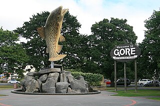
Gore is a town and district in the Southland region of the South Island of New Zealand. It has a resident population of 8,290 as of June 2024. Gore is known for its country music scene and hosts an annual country music festival. The town is also surrounded by farmland and is an important centre for agriculture in the region.
Waimea is a common place name in Hawaii and New Zealand. In Hawaiian, it means reddish water; in Māori it means forgotten or hidden stream. It may refer to:
The Southland Plains is a general name given to several areas of low-lying land in the South Island of New Zealand, separated by the rise of the Hokonui Hills in the north. It forms a sizeable area of Southland region and encompasses its two principal settlements the city of Invercargill and the town of Gore. The Southland Plains include some of New Zealand's most fertile farmland.
The Aparima River, earlier known as Jacob's River, is one of the southward-flowing braided rivers of Southland, New Zealand.

The Hokonui Hills, also known as The Hokonui Mountains or simply The Hokonui, are a range of hills in central Southland, New Zealand. They rise to 600 metres above the surrounding Southland Plains, of which the hills mark a northern extremity.
Waimea River may refer to either of two rivers at opposite ends of the South Island of New Zealand, both surrounded by fertile floodplains known locally as the Waimea Plains:

Moturoa / Rabbit Island is a small island that lies across the southernmost part of Tasman Bay / Te Tai-o-Aorere, on the northern coast of New Zealand's South Island. The long narrow island runs east–west for 8 kilometres (5 mi), and covers 15 km2 (5.8 sq mi).
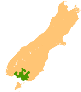
The Waimea River is a tributary of the Mataura River in Southland, New Zealand. The Waimea Plains around this river form part of the Southland Plains.
The Waimea Plains Railway was a secondary railway line that linked the towns of Lumsden and Gore in northern Southland, New Zealand. It skirted the Hokonui Hills, and operated as a through route between 31 July 1880 and 1 April 1971, with the short section from Lumsden to Balfour continuing as the Balfour Branch until 15 January 1978.

The Waikaia Branch, also known as the Switzers Branch, was a branch line railway in Southland, New Zealand. Proposed as early as the 1870s, it was not opened until 1909 and was operated by the New Zealand Railways Department for half a century until its closure in 1959.
Balfour is a small town located in the Southland region of New Zealand.
The Mokoreta River is a river in Southland, New Zealand. A tributary of the Mataura River, its source is between Mt Rosebery and Catlins Cone, close to the source of the Catlins River. It flows westward from the Catlins Ranges into the Southland Plains. Its total length is 50 kilometres (31 mi), and it flows into the Mataura River about 5 kilometres (3 mi) south of the town of Wyndham.
Athol is a small town in Southland, New Zealand. It is located on State Highway 6, 55 km south of Queenstown, halfway between Lumsden and Kingston on the Southern Scenic Route. Farming has always been very important in the district, though in earlier times gold mining, centred on nearby Nokomai, was also significant. In recent decades tourist numbers have grown. The Mataura River is well known for the quality of its brown trout fishing, and the Around the Mountains Cycle Trail, opened in November 2014, has further boosted visitor figures.
Rakahouka is a community in the Southland region of New Zealand's South Island. It is located in a fertile farming area on the Southland Plains just south of the Makarewa River. The nearest major city, Invercargill, is approximately 15 km to the southwest, and nearby villages include Grove Bush and Mabel Bush to the north, Woodlands to the southeast, and Myross Bush and Roslyn Bush to the southwest.
Murihiku is a region of the South Island in New Zealand, as used by the Māori people. Traditionally it was used to describe the portion of the South Island below the Waitaki River, but now is mostly used to describe the province of Southland. The name means 'the tail end '.
The Waikaia River is a river in New Zealand, a tributary of the Mataura River. The name is probably a corruption of Wai-o-Whakaea.
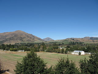
Waimea Plain(s) could refer to the following areas in New Zealand:

Southland is New Zealand's southernmost region. It consists of the southwestern portion of the South Island and includes Stewart Island. Southland is bordered by the culturally similar Otago Region to the north and east, and the West Coast Region in the extreme northwest. The region covers over 3.1 million hectares and spans 3,613 km of coastline. As of June 2023, Southland has a population of 103,900, making it the eleventh-most-populous New Zealand region, and the second-most sparsely populated. Approximately half of the region's population lives in Invercargill, Southland's only city.

The Southland Syncline is a major geological structure located in the Southland Region of New Zealand's South Island. The syncline folds the Mesozoic greywackes of the Murihiku Terrane. The northern limb of the fold is steep to overturned, while the southern limb dips shallowly to the northeast. The axial plan dips to the northeast and the axis plunges to the southeast.

The Southern District Health Board was a district health board which provided healthcare to an area covering the southern half of the South Island of New Zealand. In July 2022, the Southern DHB was dissolved as part of a nationwide overhaul of the district health board system. Its former functions and responsibilities were taken over by Te Whatu Ora.
References
- ↑ "Waimea Plains - Environment Southland". www.es.govt.nz. Retrieved 3 November 2024.
| Authority control databases: National |
|---|
45°59′29″S168°49′34″E / 45.9913°S 168.8261°E
| | This Southland Region geography article is a stub. You can help Wikipedia by expanding it. |