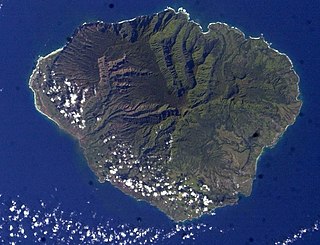
Kauaʻi, anglicized as Kauai, is geologically the second-oldest of the main Hawaiian Islands. With an area of 562.3 square miles, it is the fourth-largest of the islands and the 21st-largest island in the United States. Nicknamed the Garden Isle, Kauaʻi lies 73 miles across the Kauaʻi Channel, northwest of Oʻahu. It is the site of Waimea Canyon State Park and the Na Pali Coast State Park.
Kauaʻi County is a county in the U.S. state of Hawaiʻi. It consists of the islands of Kauaʻi, Niʻihau, Lehua, and Kaʻula. As of the 2020 Census the population was 73,298. The county seat is Līhuʻe.

Waimea is a landlocked census-designated place (CDP) in Hawaii County, Hawaii, United States. The population was 7,028 at the 2000 census and 9,212 at the 2010 census. Since each U.S. state cannot have more than one post office of the same name, and there is a post office in Waimea, Kauai County, the official U.S. Post Office designation for Waimea is Kamuela, although this name is only used by the post office, not by locals or the local government. The name Waimea means reddish water.

Pūpūkea is a community and census-designated place (CDP) in the Koʻolauloa District on the island of Oʻahu, City & County of Honolulu, Hawaii, United States. In Hawaiian, pūpūkea means "white shell". As of the 2020 census, the CDP had a population of 5,130. The Koʻolauloa District ends at Waimea Bay, with the Waialua District extending south and westward.

Waimea is a census-designated place (CDP) in Kauaʻi County, Hawaiʻi, United States. The population was 2,057 at the 2020 census. The first Europeans to reach Hawaii landed in Waimea in 1778.

Waimea Bay is located in Haleiwa on the North Shore of O'ahu in the Hawaiian Islands at the mouth of the Waimea River. Waimea Valley extends to the east of Waimea Bay. Waimea means "reddish water" in Hawaiian.
Waimea River may refer to

The Waimea River is the largest and the longest river on the island of Kauai in the U.S. state of Hawaii. At 35.7 km (22.2 mi) in length, it is the 3rd longest rivers in the Hawaiian Islands, draining one sixth of the total area of the island.

Waimea Canyon, also known as the Grand Canyon of the Pacific, is a large canyon, approximately ten miles (16 km) long and up to 3,000 feet deep, located on the western side of Kauaʻi in the Hawaiian Islands of the United States. Waimea is Hawaiian for "reddish water", a reference to the erosion of the canyon's red soil. The canyon was formed by a deep incision of the Waimea River arising from the extreme rainfall on the island's central peak, Mount Waiʻaleʻale, among the wettest places on earth.
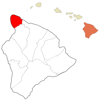
Kohala is the name of the northwest peninsula of the island of Hawaiʻi in the Hawaiian Archipelago. In ancient Hawaii it was often ruled by an independent High Chief called the Aliʻi Nui. In modern times it is divided into two districts of Hawaii County: North Kohala and South Kohala. Locals commonly use the name Kohala to refer to the census-designated places of Halaʻula, Hāwī, and Kapaʻau collectively. The dry western shore is commonly known as the Kohala Coast, which has golf courses and seaside resorts.
Waimea is a common place name in Hawaii and New Zealand. In Hawaiian, it means reddish water; in Māori it means forgotten or hidden stream. It may refer to:
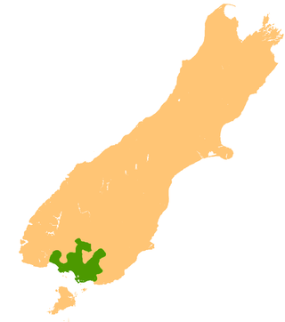
The Southland Plains is a general name given to several areas of low-lying land in the South Island of New Zealand, separated by the rise of the Hokonui Hills in the north. It forms a sizeable area of Southland region and encompasses its two principal settlements the city of Invercargill and the town of Gore. The Southland Plains include some of New Zealand's most fertile farmland.
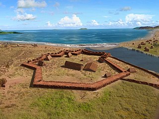
Pā'ula'ula State Historical Park is a National Historic Landmark and is administered as the Pā'ula'ula State Historical Park just southeast of present-day Waimea on the island of Kauaʻi in Hawaiʻi. It is located at the site of the former Fort Elizavety, the last remaining Russian fort on the Hawaiian islands, built in the early 19th century by the Russian-American Company as the result of an alliance with High Chief Kaumualiʻi. The star fort was employed by the Kingdom of Hawaii in the 19th century under the name Fort Hipo.
Puʻu o Mahuka Heiau State Historic Site on the North Shore of Oʻahu is the largest heiau (temple) on the island, covering 2 acres (8,100 m2) on a hilltop overlooking Waimea Bay and Waimea Valley. From its commanding heights, sentries could once monitor much of the northern shoreline of Oʻahu, and even spot signal fires from the Wailua Complex of Heiaus on Kauaʻi, with which it had ties. It was designated a National Historic Landmark in 1962, when it became the center of a 4-acre (16,000 m2) state park. It was added to the National Register of Historic Places in 1966.

Waimea Valley is an area of historic cultural significance on the North Shore of Oahu, Hawaii. The valley, being an important place in Hawaiian religion, includes several historical structures including stone terraces and walls constructed during the time of the Hawaiian monarchy. The nutrient-rich volcanic soil combined with a rainy environment provided the resourceful Hawaiians of the area the opportunity to create one of the most prosperous farming communities in all of Polynesia. The area had complex fish ponds, domesticated animal pens, various large farming beds, and was famous for the cultivation of pink taro root stock, a coveted item to the Ali`i. Much of the garden floor was once cultivated for taro, sweet potato, and bananas, with new crops and orchards introduced by Europeans after their arrival.
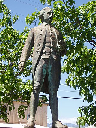
The Cook Landing Site in Waimea on Kauaʻi island in Hawaii, is where Captain James Cook landed at the mouth of the Waimea River on January 20, 1778. Cook was the first European reported to have sighted the Hawaiian Islands, and the January 20 landfall on southwestern Kauaʻi was his first arrival upon Hawaiian soil. Cook Landing Site was registered as a National Historic Landmark on December 29, 1962. The landing is principally commemorated at Hofgaard Park, a small county park located near the supposed landing site.
Waimea-Picton was a parliamentary electorate in the Marlborough and Nelson Regions of New Zealand, from 1887 to 1893.
Waimea was a parliamentary electorate in the Nelson Province of New Zealand, from 1853 to 1887. Initially represented by two members, it was a single-member electorate from 1861.

The Waimea Plains is a small but fertile area of low-lying land southwest of the port city of Nelson, situated on Tasman Bay / Te Tai-o-Aorere in the South Island of New Zealand. It is irrigated by the Waimea River from the Waimea Inlet in the north and bounded by the town of Brightwater in the south. The fertile soil promotes the growth of kiwifruit, apples and vineyards.

The Waimea River is a river in Honolulu County on the island of Oʻahu in the U.S. state of Hawaii. The river's main channel is 1.5 miles (2.4 km) long and has a watershed spanning 13.6 square miles, with a total length of 24.4 km (15.2 mi) when its tributaries are included. It is formed by the confluence of the Kamananui stream and the Kaiwikoʻele stream northeast of Haleiwa and flows northwest through the Waimea Valley to the Pacific Ocean at Waimea Bay. The name Waimea translates to "red water."
