Related Research Articles
The Murray River is a minor river on Stewart Island / Rakiura of New Zealand. It enters the Foveaux Strait sea on the eastern side of the island.

The Recovery Glacier is a glacier, at least 60 nautical miles long and 40 nautical miles wide at its mouth, flowing west along the southern side of the Shackleton Range in Antarctica.
Tucker Glacier is a major valley glacier of Victoria Land, Antarctica, about 90 nautical miles long, flowing southeast between the Admiralty Mountains and the Victory Mountains to the Ross Sea. There is a snow saddle at the glacier's head, just west of Homerun Range, from which the Ebbe Glacier flows northwestward.
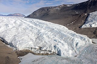
The Taylor Glacier is a glacier in Antarctica about 35 nautical miles long, flowing from the plateau of Victoria Land into the western end of Taylor Valley, north of the Kukri Hills. It flows to the south of the Asgard Range. The middle part of the glacier is bounded on the north by the Inland Forts and on the south by Beacon Valley.

Arapito is a town in the Karamea area of New Zealand. Arapito is a farming community on the south side of the Karamea River, upriver from the main Karamea township.
Romahapa is a locality in the Catlins region of Otago in New Zealand's South Island. It is located between the towns of Balclutha and Owaka. The last shop closed in 1977.
Orepuki in Southland, New Zealand is a small country township on the coast of Te Waewae Bay some 20 minutes from Riverton, 15 minutes from Tuatapere and 50 minutes from Invercargill that sits at the foot of the Longwood Range. Once a thriving gold mining settlement of 3000 people, today Orepuki is something of a ghost town with an assortment of abandoned stores, goldmining relics and sluicing scars as the only reminders of its former glory.
Waimate Creek is a natural watercourse in the southern Canterbury region of New Zealand's South Island. Its original Māori name was Te Waimatemate, which means "slowly moving waters".
Finegand is a locality in the South Otago region of New Zealand's South Island.
The Freshwater River is the longest river on Stewart Island, the third largest of New Zealand's islands. It arises close to the island's northwestern point, from which it is separated by a ridge, and flows southeastward through the Ruggedy Flat for 25 kilometres (16 mi) before reaching the Paterson Inlet on the island's central east coast. The Freshwater is the longest New Zealand river not to be located in either of the country's two main islands.
Prince of Wales Glacier is a glacier in the Queen Elizabeth Range, flowing generally north for about 10 nautical miles (18 km) between Hochstein and Kohmyr Ridges into Hamilton Glacier. Named by the northern party of the New Zealand Geological Survey Antarctic Expedition (NZGSAE) (1961–62) for Charles, Prince of Wales, eldest son of Elizabeth II of the United Kingdom.
Masindray is a town and commune in Madagascar. It belongs to the district of Soavinandriana, which is a part of Itasy Region. The population of the commune was estimated to be approximately 6,000 in 2001 commune census.

The Clifden Suspension Bridge is a historic suspension bridge near Clifden, New Zealand with a single lane. Built in 1899, it spans the Waiau River and is 111.5 m long.
The Edison River is a river of the Westland District of New Zealand. It arises in the Solution Range near Mount Elliot and flows north-west and north into the Mahitahi River.
The Orauea River is a river in New Zealand, a tributary of the Waiau River in Southland.
The Pourakino River is a river in New Zealand, flowing into the Jacobs River Estuary at Riverton.
The Rakeahua River is a river in Stewart Island/Rakiura, New Zealand, flowing into Paterson Inlet.
Barnett Glacier is a large glacier in the Anare Mountains that flows east along the south side of Tapsell Foreland into Smith Inlet, northern Victoria Land, Antarctica.

Otter Highlands is a group of peaks and ridges extending northwest-southeast for 17 nautical miles from Mount Lowe to Wyeth Heights, located west of Blaiklock Glacier and forming the west end of the Shackleton Range. Surveyed by the Commonwealth Trans-Antarctic Expedition in 1957. Named by the United Kingdom Antarctic Place-Names Committee (UK-APC) in 1972 after the De Havilland Otter aircraft which supported the CTAE.
References
"Place name detail: Waimeamea River". New Zealand Gazetteer. New Zealand Geographic Board . Retrieved 12 July 2009.
46°16′S167°44′E / 46.267°S 167.733°E