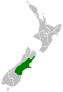
Canterbury is a region of New Zealand, located in the central-eastern South Island. The region covers an area of 44,508 square kilometres (17,185 sq mi), and is home to a population of 624,000.

The South Island, also officially named Te Waipounamu, is the larger of the two major islands of New Zealand in surface area; the other being the smaller but more populous North Island. It is bordered to the north by Cook Strait, to the west by the Tasman Sea, and to the south and east by the Pacific Ocean. The South Island covers 150,437 square kilometres (58,084 sq mi), making it the world's 12th-largest island. It has a temperate climate.

A lagoon is a shallow body of water separated from a larger body of water by barrier islands or reefs. Lagoons are commonly divided into coastal lagoons and atoll lagoons. They have also been identified as occurring on mixed-sand and gravel coastlines. There is an overlap between bodies of water classified as coastal lagoons and bodies of water classified as estuaries. Lagoons are common coastal features around many parts of the world.

Otago is a region of New Zealand in the south of the South Island administered by the Otago Regional Council. It has an area of approximately 32,000 square kilometres (12,000 sq mi), making it the country's third largest local government region. Its population was 229,200 in June 2018.
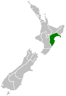
Hawke's Bay Region is a region of New Zealand on the east coast of the North Island. It is governed by Hawke's Bay Regional Council, which sits in the city of Napier. The region's name derives from Hawke Bay, which was named by Captain James Cook in honour of Admiral Edward Hawke.

Gisborne is a city in northeastern New Zealand and the largest settlement in the Gisborne District. It has a population of 37,200. The district council has its headquarters in Whataupoko, in the central city.

The Waikato River is the longest river in New Zealand, running for 425 kilometres (264 mi) through the North Island. It rises in the eastern slopes of Mount Ruapehu, joining the Tongariro River system and flowing through Lake Taupo, New Zealand's largest lake. It then drains Taupo at the lake's northeastern edge, creates the Huka Falls, and flows northwest through the Waikato Plains. It empties into the Tasman Sea south of Auckland, at Port Waikato. It gives its name to the Waikato Region that surrounds the Waikato Plains. The present course of the river was largely formed about 17,000 years ago. Contributing factors were climate warming, forest being reestablished in the river headwaters and the deepening, rather than widening, of the existing river channel. The channel was gradually eroded as far up river as Piarere, leaving the old Hinuera channel through the Hinuera Gap high and dry. The remains of the old river path can be clearly seen at Hinuera where the cliffs mark the ancient river edges. The river's main tributary is the Waipa River, which has its confluence with the Waikato at Ngaruawahia.

Whanganui, also spelled Wanganui, is a city on the west coast of the North Island of New Zealand. The Whanganui River, New Zealand's longest navigable waterway, runs from Mount Tongariro to the sea. Whanganui is part of the Manawatu-Wanganui region.

The Rangitikei River is one of New Zealand's longest rivers, 185 kilometres (115 mi) long.

The Waiau Toa / Clarence River is on northeast South Island of New Zealand. It is 230 kilometres (140 mi) long, which makes it the eighth longest river in New Zealand.

The Whanganui River is a major river in the North Island of New Zealand. It is the country's third-longest river, and has special status owing to its importance to the region's Māori people. In March 2017 it became the world's second natural resource to be given its own legal identity, with the rights, duties and liabilities of a legal person. The Whanganui Treaty settlement brought the longest-running litigation in New Zealand history to an end.
The Waikaka Branch was a branch line railway of the Main South Line that ran through agricultural and gold-mining country in Southland, New Zealand. It was constructed in 1907 and 1908, and was operated by the New Zealand Railways Department until its closure in 1962.
The Tapanui Branch was a railway line located near the border of the regions of Southland and Otago, New Zealand. Although the name suggests that it terminated in Tapanui, its furthest terminus was actually in Edievale. Construction of the line began in 1878 with the first section opened in 1880, and it operated until 1978, when it was destroyed by flooding from the Pomahaka River.

The Zealand River is a 6.3-mile (10.1 km) long river in the White Mountains of New Hampshire in the United States. It is a tributary of the Ammonoosuc River and part of the Connecticut River watershed.

Kelso is an abandoned small settlement in Otago, New Zealand, located ten kilometres north of Tapanui on the Crookston Burn, close to its junction with the larger Pomahaka River. Its population during the 1960s and 1970s was close to 300, with most of its economy based on sheep farming. A small dairy factory was a focal point in the village's early years.

Lower Hutt is a city in the Wellington Region of the North Island of New Zealand. Administered by the Hutt City Council, it is one of the four cities that constitute the Wellington metropolitan area.

The Pike River Mine disaster was a coal mining accident that began on 19 November 2010 in the Pike River Mine, 46 kilometres (29 mi) northeast of Greymouth, in the West Coast region of New Zealand's South Island. A methane explosion occurred in the mine at approximately 3:44 pm. At the time of the explosion 31 miners and contractors were present in the mine. Two miners managed to walk from the mine; they were treated for moderate injuries and released from Greymouth Hospital the next day. The remaining 16 miners and 13 contractors were believed to be at least 1.5 kilometres (1,600 yd) from the mine's entrance.
Topi Patuki (1810–1900) was a New Zealand Māori leader, whaler, goldminer and storekeeper. Of Māori descent, he identified with the Ngati Mamoe iwi. He was born in Waipahi, West Otago, New Zealand in about 1810.
