Waipaparoa / Howick Beach

Last updated

Waipaparoa / Howick Beach
20220925 153915 Waipaparoa Howick Beach.jpg
View of Waipaparoa / Howick Beach at low tide, looking east
Auckland Council 2019 Wards Outlined Blank.png
Red pog.svg
Waipaparoa / Howick Beach
Location within the Auckland Region
Location Auckland Region, New Zealand
Coordinates 36°53′31″S174°56′31″E / 36.892°S 174.942°E / -36.892; 174.942 (Waipaparoa / Howick Beach)
Ocean/sea sources Hauraki Gulf

Waipaparoa / Howick Beach is a beach in the Auckland Region of New Zealand's North Island. It is located in Howick.

Contents

Description

Waipaparoa / Howick Beach is located in East Auckland in Howick, adjacent to Mellons Bay in the west and Cockle Bay in the east. Waipaparoa / Howick Beach looks out towards the Tāmaki Strait, Waiheke Island, Motukaraka Island and Beachlands. [1]

History

Watercolour by Caroline Harriet Abraham, showing Waipaparoa / Howick Beach in 1853 Looking from the parsonage over Howick Beach towards Waiheke showing the Royal Hotel, 20 January 1853.jpg
Watercolour by Caroline Harriet Abraham, showing Waipaparoa / Howick Beach in 1853
Holidaymakers at Howick Beach circa 1915, with the Howick Wharf in the background Holidaymakers, Howick Beach, ca 1915.jpg
Holidaymakers at Howick Beach circa 1915, with the Howick Wharf in the background

The Tāmaki Strait was visited by the Tainui migratory waka around the year 1300, and members of the crew settled around East Auckland and the Pōhutukawa Coast. These were the ancestors of the modern mana whenua of the area, Ngāi Tai ki Tāmaki. [2] The traditional names for the beach and surrounding bay are Paparoa and Waipaparoa, with Waipaparoa referring to the wider bay between modern-day Howick and Beachlands, including the Turanga Creek. [2] The Howick area was extensively cultivated, but as the area was relatively exposed, two fortified were constructed: Paparoa Pā at the south-eastern end of Waipaparoa / Howick Beach, and Tūwakamana Pā above Cockle Bay. In addition to agriculture, the Waipaparoa / Howick Beach area was known for pioke (shortspine spurdog sharks), which were caught in the near-by estuaries and dried at the beach. [2] In the 1600s, the warrior Kāwharu attacked and raised Paparoa Pā, without taking occupation of the lands. While the wider area was still cultivated, the site of Paparoa Pā became a wāhi tapu (sacred and restricted) site to Ngāi Tai. [2] [3]

In 1836, English Missionary William Thomas Fairburn brokered a land sale between Tāmaki Māori chiefs, Pōtatau Te Wherowhero and Turia of Ngāti Te Rau, covering the majority of modern-day South Auckland, East Auckland and the Pōhutukawa Coast. [4] The sale was envisioned as a way to end hostilities in the area, but it is unclear what the chiefs understood or consented to. Māori continued to live in the area, unchanged by this sale. [5] Fairburn's Purchase was investigated by the New Zealand Land Commission found to be excessive and reduced in size. The disallowed parts of his purchase were not returned to Ngāi Tai, however in 1854 a reserve was created for Ngāi Tai around the Wairoa River and Umupuia. [6] As a part of this arrangement, Ngāi Tai agreed not to settle elsewhere in the region, which included Waipaparoa / Howick Beach. [7]

In 1847, Howick township was established as a defensive outpost for Auckland, by fencibles (retired British Army soldiers) and their families. [8] Many of the ships transporting the fencibles arrived at Waipaparoa / Howick Beach, including the Minerva and Sir Robert Sale. [9] Ships used to offload passengers directly onto the sandstone reef, and since the early colonial era, the beach developed a reputation as being dangerous, due to numerous shipwrecks and drownings. [10] In 1854, wharf was constructed on the beach, however was only usable at high tide. Many ferries preferred to disembark passengers at the Shelly Park sandspit, despite being further away from Howick. [10] [11] In 1896, a new 240 metre-long wharf was constructed at Waipaparoa / Howick Beach. [11]

At the turn of the 20th century, the beach had started to become a popular location for excursions and holidays. In 1905, bathing sheds were erected at the beach, [12] and in the 1920s the northern area of the beach was subdivided for housing. [13]

During World War II, an anti-tank trench was dug at the eastern end of the beach, which over time primarily used by children as a changing area. The trench was covered up a few years after construction, due to little blue penguins getting trapped inside. [14] From 1956, the Howick Volunteer Coastguard has patrolled the beach. [15]

Amenities

The beach is a popular location for picnics and swimming, [16] and has several boat ramps. [17]

Related Research Articles

<span class="mw-page-title-main">Howick, New Zealand</span> Suburb in Auckland, New Zealand

Howick is a suburb of East Auckland, New Zealand. The area was traditionally settled by Ngāi Tai ki Tāmaki, and in 1847 Howick was established as a defensive settlement for Auckland, by veteran fencible soldiers of the British Army. Howick was a small agricultural centre until the 1950s, when it developed into a suburban area of Auckland. Modern Howick draws much of its character from the succeeding waves of Asian settlement that it has experienced since New Zealand's immigration reforms of the 1980s, with a strong Chinese New Zealander presence in the suburb's business and education sectors.

<span class="mw-page-title-main">Tāmaki Strait</span>

The Tāmaki Strait is an area of the Hauraki Gulf in the Auckland Region of New Zealand's North Island. The strait is east of the Waitematā Harbour, and is located between Waiheke Island, East Auckland and the Pōhutukawa Coast.

<span class="mw-page-title-main">Pakuranga</span> Suburb in Auckland, New Zealand

Pakuranga is an eastern suburb of Auckland, in northern New Zealand. Pakuranga covers a series of low ridges and previously swampy flats, now drained, that lie between the Pakuranga Creek and Tamaki River, two estuarial arms of the Hauraki Gulf. It is located to the north of Manukau and 15 kilometres southeast of the Auckland CBD.

<span class="mw-page-title-main">Beachlands, New Zealand</span> Suburb in Auckland, New Zealand

Beachlands is an outer suburb of Auckland, New Zealand, established in the 1920s, where development increased in the 1950s due to its popularity as a beach holiday destination. It is located on the Pōhutukawa Coast and in close proximity to Maraetai.

Botany Downs is an eastern suburb of the city of Auckland, New Zealand. This residential area previously formed part of the East Tāmaki area. In terms of local-body administration, the suburb lies in the Howick ward, one of the thirteen administrative divisions of the Auckland Council.

<span class="mw-page-title-main">Shelly Park</span> Suburb in Auckland, New Zealand

Shelly Park is a suburb of East Auckland, in northern New Zealand. The suburb is in the Howick ward, one of thirteen electoral divisions of the Auckland Council. It is named after the beach of the same name.

<span class="mw-page-title-main">Cockle Bay, New Zealand</span> Suburb in Auckland, New Zealand

Cockle Bay is a suburb of East Auckland, New Zealand. The suburb is in the Howick ward, one of the 13 administrative divisions of Auckland city and currently under governance of the Auckland Council.

Highland Park is a suburb of Auckland, New Zealand, located between Howick and Pakuranga. It belongs to the Pakuranga electorate which is currently represented by Simeon Brown.

<span class="mw-page-title-main">Farm Cove, New Zealand</span> Suburb in Auckland, New Zealand

Farm Cove is a suburb located in East Auckland, New Zealand. The suburb is in the Howick ward, one of the thirteen administrative divisions of Auckland. The Rotary Walkway Reserve runs through Farm Cove.

<span class="mw-page-title-main">Eastern Beach, New Zealand</span> Suburb in Auckland, New Zealand

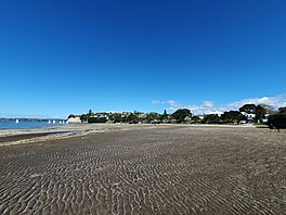
Eastern Beach is a suburb of Auckland, New Zealand. Located on the eastern city of the city centre, the suburb is in the Howick ward, one of the thirteen administrative divisions of Auckland City. Its most common attraction is a popular white-sand palm fringed beach, also called Eastern Beach, with summer temperatures attracting thousands of people from neighbouring suburbs to the beach to enjoy the shallow waters, and shops and parks within close vicinity. At the southern end of the beach is a boat ramp giving high-medium tide access to the dedicated water skiing zone adjacent to the beach. This was a popular area for gathering Pipi and Cockles, but overuse has seen a rāhui or ban placed on the beach. It is part of the Bucklands Beach peninsula.

<span class="mw-page-title-main">East Auckland</span> Region of Auckland, New Zealand

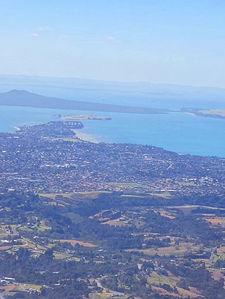
East Auckland is one of the major geographical regions of Auckland, the largest city in New Zealand. Settled in the 14th century, the area is part of the traditional lands of Ngāi Tai ki Tāmaki. The area was developed into farmland in the 1840s, and the town of Howick was established as a defensive outpost by fencibles to protect Auckland. Coastal holiday communities developed in the area from the 1910s, and from the 1950s underwent major redevelopment into a suburban area of greater Auckland. From the 1980s, the area saw significant Asian New Zealander migrant communities develop.

<span class="mw-page-title-main">Maraetai</span> Place in Auckland Region, New Zealand

Maraetai is a coastal town to the east of Auckland in New Zealand, on the Pōhutukawa Coast. Part of the traditional rohe of Ngāi Tai Ki Tāmaki, the area developed into a coastal holiday community in the early 20th Century.

<span class="mw-page-title-main">Half Moon Bay, Auckland</span> Suburb in Auckland, New Zealand

Half Moon Bay, is a suburb of East Auckland, New Zealand, lying immediately south of Bucklands Beach. It is home to the Half Moon Bay Marina, where over 500 boats berth. It is located on the Tāmaki River in the Hauraki Gulf.

<span class="mw-page-title-main">Sunnyhills</span> Suburb in Auckland, New Zealand

Sunnyhills is a suburb of East Auckland, New Zealand, located on the eastern banks of the Tāmaki River near Pakuranga. Previously farmland within the Pakuranga Town District, suburban housing developed in the area in the mid-1960s.

Burswood is a residential suburb of Auckland which is separated from the rest of the city by the Pakuranga Stream on its west, north and eastern sides, and the major road Ti Rakau Drive on its south. Population density is higher than in most of Auckland, with no quarter acre sections.

<span class="mw-page-title-main">Golflands</span> Suburb in Auckland, New Zealand

Golflands is an eastern suburb of the city of Auckland, New Zealand. The Pakuranga Golf Club is part of the suburb, and many of the streets have names related to golf or notable golf players, such as Bob Charles drive.

<span class="mw-page-title-main">Somerville, New Zealand</span> Suburb in Auckland, New Zealand

Somerville is an eastern suburb of the city of Auckland, New Zealand. Most of the houses were built in the 1990s. Before 1990, the area was rural.

<span class="mw-page-title-main">Pōhutukawa Coast</span> Region of Auckland, New Zealand

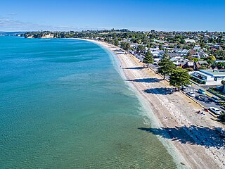
The Pōhutukawa Coast is an area of the Auckland Region in New Zealand. The area covers townships south of the Tāmaki Strait: Whitford, Beachlands, Maraetai and Umupuia. The area was traditionally known as Maraetai, and is within the rohe of Ngāi Tai ki Tāmaki. In the 1920s, seasonal holiday communities developed in the area, which became permanent residential towns by the 1950s.

<span class="mw-page-title-main">Tūranga Creek</span> River in Auckland Region, New Zealand

Tūranga Creek, also known as the Tūranga River or Tūranga Estuary, is a stream and tidal estuary in the Auckland Region of New Zealand's North Island. The township of Whitford was founded at the navigable headlands of the creek.

<span class="mw-page-title-main">Pakuranga Creek</span> Stream in East Auckland, New Zealand

Pakuranga Creek is a tidal estuary and stream in the Auckland Region of New Zealand's North Island. The creek flows from inlant Pakuranga, meeting the Pakuranga Stream and flows into the Tāmaki River.

References

  1. "Waipaparoa / Howick Beach". New Zealand Gazetteer. Land Information New Zealand. Retrieved 21 June 2023.
  2. 1 2 3 4 Green, Nathew (2011). "From Hawaīki to Howick – A Ngāi Tai History". Grey's Folly: A History of Howick, Pakuranga, Bucklands-Eastern Beaches, East Tamaki, Whitford, Beachlands and Maraetai. By La Roche, Alan. Auckland: Tui Vale Productions. pp. 16–33. ISBN   978-0-473-18547-3. OCLC   1135039710.
  3. Ngāi Tai Ki Tāmaki and the Trustees of the Ngāi Tai Ki Tāmaki Trust and the Crown (7 November 2015). "Deed of settlement schedule documents" (PDF). NZ Government. Archived (PDF) from the original on 13 February 2020. Retrieved 31 October 2021.
  4. "13 June 1865". Auckland Libraries Heritage Collections. MJ_0760. Retrieved 19 June 2023.
  5. Moore, D; Rigby, B; Russell, M (July 1997). Rangahaua Whanui National Theme A: Old Land Claims (PDF) (Report). Waitangi Tribunal . Retrieved 5 March 2023.
  6. Clough, Tom; Apfel, Aaron; Clough, Rod (June 2020). 109 Beachlands Road, Beachlands, Auckland: Preliminary Archaeological Assessment (PDF) (Report). Environmental Protection Authority . Retrieved 21 October 2022.
  7. Heritage Department of the Auckland Regional Council. "Duder Regional Park – Our History" (PDF). Auckland Council . Retrieved 30 August 2021.
  8. La Roche, Alan 2011, pp. 48.
  9. La Roche, Alan 2011, pp. 54.
  10. 1 2 La Roche, Alan (13 May 2018). "Is Howick Beach a hazard?". Times Online. Retrieved 21 June 2023.
  11. 1 2 "February 1896". Auckland Libraries Heritage Collections. MJ_1385. Retrieved 21 June 2023.
  12. "7 February 1905". Auckland Libraries Heritage Collections. MJ_1512. Retrieved 21 June 2023.
  13. "11 April 1923". Auckland Libraries Heritage Collections. MJ_2073. Retrieved 21 June 2023.
  14. La Roche, Alan 2011, pp. 260–261.
  15. "60 years of the Howick Volunteer Coastguard". Times Online. 15 November 2017. Retrieved 21 June 2023.
  16. "Howich Beach". LAWA. Auckland Council . Retrieved 21 June 2023.
  17. "Howich Beach". Auckland Council . Retrieved 21 June 2023.

Bibliography