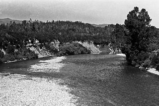
The Inangahua River is located in the north-west of New Zealand’s South Island. It is a major tributary of the Buller River, where it joins at the town of Inangahua Junction.
The Commonwealth Range is a north-south trending range of rugged mountains, 60 nautical miles long, located within the Queen Maud Mountains on the Dufek Coast of the continent of Antarctica. The range borders the eastern side of Beardmore Glacier from Keltie Glacier to the Ross Ice Shelf. The range is southeast of the Queen Alexandra Range, which is to the west of the Beardmore Glacier. It is west of the Hughes Range and north of the Supporters Range and the Barton Mountains.

The Tairua River is a river located on the east coast of the Coromandel Peninsula in the North Island of New Zealand.
Waterton is a former town in the Canterbury region of New Zealand's South Island. It is still officially recognised as a locality.
The Glenrae River is a river in the Canterbury region of New Zealand. It arises in the Glynn Wye Range near Mount Skiddaw and flows through the Lake Sumner Forest Park south and then south-east into the Hurunui River, which exits in the Pacific Ocean. Its tributaries include Devils Creek and Robyne Creek.

The Harman River is a river of New Zealand. It starts in the Browning Range of the Southern Alps and becomes the Arahura River, which flows into the Tasman Sea north of Hokitika.
The Hewson River is a river of New Zealand's South Island. It flows east and then south from the Ben McLeod Range of inland Canterbury before flowing into the upper reaches of the Orari River 5 kilometres (3 mi) west of Mount Peel.
The Kaniere River is a river of New Zealand. It is located in the West Coast Region of the South Island. The river is the outflow of Lake Kaniere, and flows west to reach the Hokitika River five kilometres from the coast of the Tasman Sea.

The Kokatahi River is a river of the West Coast Region of New Zealand's South Island. A major tributary of the Hokitika River, it flows northwest from its origins on the northern slopes of Mount Ambrose, reaching the Hokitika River 12 kilometres from the latter's mouth at Hokitika. The two rivers between them share one of the West Coast's larger floodplains.
The Little Hohonu River is a river of New Zealand's West Coast Region. It flows northwest from its origins in the Hohonu Range southwest of Lake Brunner, reaching the Greenstone River / Hokonui 20 kilometres southeast of Greymouth.
The Montgomerie River is a river in the Buller District of New Zealand's South Island. It flows southwest from the Victoria Range to reach the Waitahu River 12 kilometres (7.5 mi) east of Reefton. The river's entire length is within Victoria Forest Park.
The Nancy River is a river of the West Coast Region of New Zealand's South Island. A tributary of the Ahaura River, it flows generally southwest from its source to the west of Mount Hochstsetter in the Southern Alps, turning west shortly before its outflow, 15 kilometres southeast of Lake Hochstetter.
The Rough River, alternatively known as the Otututu River is a river of the West Coast Region of New Zealand's South Island. A major tributary of the Grey River, it flows south from its sources near Mount Uriah in the Paparoa Range 20 kilometres southeast of Charleston, to reach the Grey River to the southwest of the settlement of Ikamatua. The river is currently shown on maps as Otututu (Rough) River, although this orthography is no longer common for New Zealand Rivers.

The Toaroha River is a river of the West Coast Region of New Zealand's South Island. It flows generally north through a valley between the Toaroha and Diedrichs Ranges to reach the Kokatahi River 25 kilometres southeast of Hokitika.
The Waikiti River is a river of the West Coast Region of New Zealand's South Island. It flows generally north from it sources in the eastern Kaimata Range, roughly paralleling the course of its larger eastern neighbour, the Trent River. It reaches the Ahaura River 20 kilometres southeast of Lake Hochstetter.
The Big River is a river in the Grey District, in the West Coast region of New Zealand's South Island. It is a tributary of the Grey River.

The Styx River is a river of the West Coast Region of New Zealand. It flows west for 16 km from Styx Saddle into the Kokatahi River, through native bush for the majority of its length.
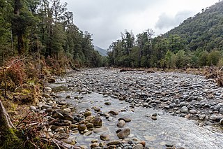
The Taipo River is a river of the central West Coast Region of New Zealand's South Island. It flows north from its sources west of Mount Rolleston, fed by the waters of several mountain streams. After some 15 kilometres it turns northeast to flow past the Bald Range before reaching the valley of the Taramakau River into which it flows 35 kilometres east of Hokitika.
TeMoana is a locality in the Canterbury Region of the South Island of New Zealand. It is located about 15 kilometres (9.3 mi) west of Geraldine and bordered by Gapes Valley and Pleasant Valley to the south and Four Peaks to the north. The south branch of the Hae Hae Te Moana River runs through the area.
