Minamoto no Sanetomo was the third shōgun of the Kamakura shogunate. He was the second son of the Kamakura shogunate founder, Minamoto no Yoritomo. His mother was Hōjō Masako and his older brother was second Kamakura shogun Minamoto no Yoriie.

Hirado, historically known as Firando is a city located in Nagasaki Prefecture, Japan. The part historically named Hirado is located on the Hirado Island. With recent mergers, the city's boundaries have expanded, and Hirado now occupies parts of the main island of Kyushu. The components are connected by the Hirado Bridge.

Odaiba (お台場) today is a large artificial island in Tokyo Bay, Japan, across the Rainbow Bridge from central Tokyo. Daiba were initially built in this area for defensive purposes in the 1850s. The original Odaiba opened in 1860 as a port and shipyard in the city today known as Yokosuka, site of the joint Japanese-US fleet HQ. Reclaimed land offshore Shinagawa was dramatically expanded during the late 20th century as a seaport district, and has developed since the 1990s as a major commercial, residential and leisure area. Odaiba, along with Minato Mirai 21 in Yokohama, is among a few manmade seashores in Tokyo Bay where the waterfront is accessible, and not blocked by industry and harbor areas. For artificial sand beaches in the bay, Sea Park in Kanazawa-ku is suitable for swimming, Odaiba has one, and there are two in Kasai Rinkai Park area looking over to the Tokyo Disneyland.

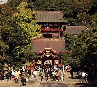
Tsurugaoka Hachimangū (鶴岡八幡宮) is the most important Shinto shrine in the city of Kamakura, Kanagawa Prefecture, Japan. The shrine is at the geographical and cultural center of the city of Kamakura, which has largely grown around it and its 1.8 km approach. It is the venue of many of its most important festivals, and hosts two museums.

Ashikaga Mochiuji was the Kamakura-fu's fourth Kantō kubō during the Sengoku period in Japan. During his long and troubled rule the relationship between the west and the east of the country reached an all-time low. Kamakura was finally attacked by shōgun Ashikaga Yoshinori and retaken by force. Mochiuji and his eldest son Yoshihisa killed themselves to escape capture.

Hakata Bay is a bay in the northwestern part of Fukuoka city, on the Japanese island of Kyūshū. It faces the Tsushima Strait, and features beaches and a port, though parts of the bay have been reclaimed in the expansion of the city of Fukuoka. The bay is perhaps most famous for the Mongol invasions of Japan of 1274 and 1281 which took place nearby; both invasions are sometimes referred to as the "Battle of Hakata Bay."

Yuigahama (由比ヶ浜海岸) is a beach near Kamakura, a city in Kanagawa Prefecture, Japan. The relation between the beach and its neighboring areas is complex. Although Yuigahama is legally the entire 3.2 km beach that goes from Inamuragasaki, which separates it from Shichirigahama, to Zaimokuza's Iijima cape, which separates it from Kotsubo and the Miura Peninsula, the name is customarily used to indicate the portion west of the Namerigawa river, while the eastern half is called Zaimokuza Beach (材木座海岸). This is the reason why, although the beach gives its name to only the west part of the beachside community, traces of the name Yuigahama can be found also in Zaimokuza. The center of Yuigahama came legally into being between 1964 and 1965 and was named after the beach. Today's Yuigahama was until then divided between Zaimokuza, Ōmachi, and Hase.

Tōshō-ji (東勝寺) was the Hōjō clan's family temple (bodaiji) in Kamakura during the Kamakura period. Its founder was Taikō Gyōyū and it was constructed in 1237 by Hōjō Yasutoki in memory of his mother, who had her tomb there. According to the Taiheiki, from its foundation until the end of the Kamakura shogunate every regent (shikken) was buried there. The temple no longer exists, since it was set on fire by the Hōjō themselves when the entire family committed suicide after Nitta Yoshisada's invasion of Kamakura on July 4, 1333. Its ruins were found in the Kasaigayatsu valley in today's Ōmachi. Tōshō-ji very probably used to occupy the entire valley. Standing at the top of a narrow valley shut off at its base by the Nameri river's deep gorge and by steep hills on the other three sides, and besides offering a clear view of the only road that crossed the river, it was a fortress surely valuable to the family also from the military point of view.

The city of Kamakura, Kanagawa in Japan, is closed off on three sides by very steep hills and on the fourth by the sea: before the construction of several modern tunnels and roads, the so-called Seven Entrances (Nana-guchi), or Seven Passes were its main links to the rest of the world. The city was therefore a natural fortress and, according to the Azuma Kagami, it was chosen by Minamoto no Yoritomo as his base specifically for this reason. The name itself seems to have been modeled on that of Kyoto's Seven Entrances (京都七口)—sometimes translated as the seven "mouths"—which first appears in the literature of the intermediate Muromachi period. Together with the other "numbered" names like "Kamakura's Ten Wells" and "Kamakura's Ten Bridges", the modern "Seven Entrances" is an Edo period invention probably concocted to stimulate tourism. The Azuma Kagami calls them simply -zaka: Kobukurozaka, Daibutsuzaka, Gokurakuzaka, etc. It must also be noted that, besides these seven, there were always other mountain roads that connected Kamakura with, for example, Kotsubo and Shichirigahama. There is one, for example, that connects Kaizō-ji in Ōgigayatsu with Kita-Kamakura Station. The Seven Entrances were simply the most convenient and important.

Moto Hachiman (元八幡) is a small but very old and historically important Shinto shrine in Kamakura, Kanagawa Pref., Japan.

Yagura are artificial caves used during the Middle Ages in Kamakura, Kanagawa Prefecture, Japan, as tombs and cenotaphs. It is likely that they were used only as tombs in the beginning, and were later used as cenotaphs. The dead are mostly from the samurai class, but the names of priests and artisans have also been found. These tombs are extremely numerous in the hills surrounding Kamakura, and estimates of their number range from 1,500 to over 5,000. The total number will remain unknown, as many have been destroyed and others may not yet have been found.

Inamuragasaki (稲村ケ崎) is a cape at the western end of Yuigahama (Beach) in Kamakura, Kanagawa Prefecture, Japan. The cape divides Yuigahama from Shichirigahama (Beach) and Enoshima. Its name seems to stem from its shape, similar to a stack of rice at harvest time. At its foot on the Shichirigahama side there is a park, the Inamuragasaki Park (稲村ケ崎海浜公園).

The Nameri River is a river that goes from the Asaina Pass in northern Kamakura, Kanagawa to the beach in Yuigahama, for a total length of about 8 km. Although Yuigahama is in fact the name of the entire 3.2 km beach that goes from Inamuragasaki to Zaimokuza's Iijima cape, the name is usually used just for its half west of the Namerigawa river's estuary, while the eastern half is called Zaimokuza Beach (材木座海岸). The name comes from the way it flows, kind of "licking" the stones at its bottom.

Ishiizan Chōshō-ji (石井山長勝寺) is a Buddhist temple of the Nichiren Shū in Kamakura, Kanagawa, Japan. It's one of a group of three built near the site in Matsubagayatsu (Valley of Pine Needles where Nichiren, founder of the Buddhist sect that bears his name, is supposed to have had his hut. The first part of its name is derived from the founder's last name, the second is an alternative reading of the characters for Nagakatsu, the founder's first name.

Kinbyōzan Zuisen-ji (錦屏山瑞泉寺) is a Buddhist temple of the Rinzai sect in Nikaidō's Momijigayatsu Valley in Kamakura, Japan. During the Muromachi period it was the family temple of the Ashikaga rulers of Kamakura : four of the five kubō are buried there in a private cemetery closed to the public and first kubō Ashikaga Motouji's is also known by the name Zuisen-ji-den (瑞泉寺殿). Designed by prominent Zen religious figure, poet and Zen garden designer Musō Soseki, the temple lies on top of an isolated hill and is famous for both its garden and its Zen rock garden. The beauty and the quantity of its plants have gained it since antiquity the nickname "Temple of Flowers" (花の寺). The main object of worship is Jizō Bosatsu. Zuisen-ji is an Historic Site and contains numerous objects classified as Important Cultural Properties and Places of Scenic Beauty.

Tenshōzan Renge-in Kōmyō-ji (天照山蓮華院光明寺) is a Buddhist temple of the Jōdo sect in Zaimokuza, near Kamakura, Japan, the only major one in the city to be close to the sea. Kōmyō-ji is number one among the Kantō Jūhachi Danrin (関東十八檀林), a group of 18 Jōdo temples established during the Edo period by Tokugawa Ieyasu, and dedicated to both the training of priests and scholarly research. It is also the sect's head temple for the Kantō region. In spite of the fact it is a Jōdo sect temple, Kōmyō-ji has several of the typical features of a Zen temple, for example a sanmon, a pond and a karesansui.

The tomb of Minamoto no Yoritomo (源頼朝の墓) is a monument in Kamakura, Kanagawa, Japan, located some hundred meters north of the site where the palace called Ōkura Bakufu, seat of Minamoto no Yoritomo's government, once stood. Although there is no evidence his remains are actually there, it is commonly assumed to be the resting place of Minamoto no Yoritomo, founder and first shōgun of the Kamakura shogunate. The cenotaph consists of a 186 cm gorintō surrounded by a stone tamagaki, and was built during the Edo period (1603–1868), far after the shōgun's death in 1199. In the course of history, the site's prestige has attracted other structures, so that now it is occupied by the Site of the Hokke-dō,, Shirahata Shrine, and the black stone stele commemorating the Hokke-dō and the mass suicide of the Miura clan. A couple of hundred meters further to the east lie the yagura of the Miura clan, the twin tombs of Oe no Hiromoto and of his son Mōri Suemitsu, and the grave of Yoritomo's illegitimate son Shimazu Tadahisa. The grave of Yoritomo and the ruins of the Hokke-dō are national Historic Sites.


