Length | 0.14 mi (0.23 km) |
---|---|
Location | Asheville, North Carolina, U.S. |
West end | Otis Street |
East end | Battery Park Avenue |
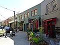
Wall Street is a thoroughfare in Asheville, North Carolina, United States. It runs for about 730 feet (240 yd) from Otis Street in the west to Battery Park Avenue in the east, and parallel to Battery Park Avenue to the north and Patton Avenue to the south. It has been referred to as a retail "woonerf," or "living street" [1] [2] and has been nicknamed The Little Street with Big Ideas. [3]
It was originally an alley used for access to businesses, but was converted to use by traffic in the 1940s. Stores began to open, with their frontages facing onto the southern side of the street. [1]
In the 1970s, a redevelopment of the street's character was undertaken to attract tourists and improve the amenities of pedestrians. [1] Today, it is home to restaurants, stores and a climbing wall. [1]
The seven-storey Public Service Building is located in the midsection of the street's southern side, while the Miles Building stands at the corner of Wall Street and Battery Park Avenue. Wall Street Parking Garage occupies a large part of the northern side of the street towards its eastern end.
Battery Park City is a mainly residential 92-acre (37 ha) planned community and neighborhood on the west side of the southern tip of the island of Manhattan in New York City. It is bounded by the Hudson River on the west, the Hudson River shoreline on the north and south, and the West Side Highway on the east. The neighborhood is named for the Battery, formerly known as Battery Park, located directly to the south.
Broadway is a road in the U.S. state of New York. Broadway runs from State Street at Bowling Green for 13 mi (21 km) through the borough of Manhattan and 2 mi (3.2 km) through the Bronx, exiting north from New York City to run an additional 18 mi (29 km) through the Westchester County municipalities of Yonkers, Hastings-On-Hudson, Dobbs Ferry, Irvington, and Tarrytown, and terminating north of Sleepy Hollow.
Venice is a neighborhood of the city of Los Angeles within the Westside region of Los Angeles County, California.
Manhattan is the most densely populated and geographically smallest of the five boroughs of New York City. The borough is also coextensive with New York County, one of the original counties of the U.S. state of New York. Located near the southern tip of the State of New York, Manhattan is based in the Eastern Time Zone and constitutes both the geographical and demographic center of the Northeast megalopolis and the urban core of the New York metropolitan area, the largest metropolitan area in the world by urban landmass. Over 58 million people live within 250 miles of Manhattan, which serves as New York City's economic and administrative center, cultural identifier, and the city's historical birthplace. Residents of the outer boroughs of New York City often refer to Manhattan as "the city". Manhattan has been described as the cultural, financial, media, and entertainment capital of the world, and hosts the United Nations headquarters. Manhattan also serves as the headquarters of the global art market, with numerous art galleries and auction houses collectively hosting half of the world's art auctions.
Walden is the largest of three villages of the town of Montgomery in Orange County, New York, United States. The population was 6,818 at the 2020 census. It has the ZIP Code 12586 and the 778 telephone exchange within the 845 area code. Walden is part of the Poughkeepsie−Newburgh−Middletown, NY Metropolitan Statistical Area as well as the larger New York−Newark−Bridgeport, NY-NJ-CT-PA Combined Statistical Area.
Fifth Avenue is a major and prominent thoroughfare in the borough of Manhattan in New York City. It stretches north from Washington Square Park in Greenwich Village to West 143rd Street in Harlem. It is one of the most expensive shopping streets in the world.
Queen Street is a major east–west thoroughfare in Toronto, Ontario, Canada. It extends from Roncesvalles Avenue and King Street in the west to Victoria Park Avenue in the east. Queen Street was the cartographic baseline for the original east–west avenues of Toronto's and York County's grid pattern of major roads. The western section of Queen is a centre for Canadian broadcasting, music, fashion, performance, and the visual arts. Over the past twenty-five years, Queen West has become an international arts centre and a tourist attraction in Toronto.
Michigan Avenue is a north-south street in Chicago which runs at 100 east on the Chicago grid. The northern end of the street is at Lake Shore Drive on the shore of Lake Michigan in the Gold Coast Historic District. The street's southern terminus is at Sibley Boulevard in the southern suburb of Harvey, though like many Chicago streets it exists in several disjointed segments.
Union Square is a historic intersection and surrounding neighborhood in Manhattan, New York City, located where Broadway and the former Bowery Road – now Fourth Avenue – came together in the early 19th century. Its name denotes that "here was the union of the two principal thoroughfares of the island". The current Union Square Park is bounded by 14th Street on the south, 17th Street on the north, and Union Square West and Union Square East to the west and east respectively. 17th Street links together Broadway and Park Avenue South on the north end of the park, while Union Square East connects Park Avenue South to Fourth Avenue and the continuation of Broadway on the park's south side. The park is maintained by the New York City Department of Parks and Recreation.
The Joe DiMaggio Highway, commonly called the West Side Highway and formerly the Miller Highway, is a 5.42-mile-long (8.72 km) mostly surface section of New York State Route 9A (NY 9A), running from West 72nd Street along the Hudson River to the southern tip of Manhattan in New York City. It replaced the West Side Elevated Highway, built between 1929 and 1951, which was shut down in 1973 due to neglect and lack of maintenance, and was dismantled by 1989. North of 72nd Street the roadway continues north as the Henry Hudson Parkway.
The Golden Mile is a commercial district in the Scarborough district of Toronto, Ontario, Canada. Situated along Eglinton Avenue East, east of Victoria Park Avenue, it was one of Canada's first model industrial parks. The original Golden Mile of Industry ran along Eglinton from Pharmacy Avenue east to Birchmount Road.
Old East York is a district of the city of Toronto, Ontario, Canada. It consists of the southern, urban, portion of the former borough of East York. Old East York is continuous and functionally integrated with the old City of Toronto, bounded by the old municipal boundary between East York and Old Toronto on the south, by the Don River Valley on the west and northwest, by Taylor-Massey Creek on the north, and Victoria Park Avenue in the east.
The Manhattan Waterfront Greenway is a waterfront greenway for walking or cycling, 32 miles (51 km) long, around the island of Manhattan, in New York City. The largest portions are operated by the New York City Department of Parks and Recreation. It is separated from motor traffic, and many sections also separate pedestrians from cyclists. There are three principal parts — the East, Harlem and Hudson River Greenways.
Vesey Street is a street in New York City that runs east-west in Lower Manhattan. The street is named after Rev. William Vesey (1674-1746), the first rector of nearby Trinity Church.
Main Street is a metonym used to denote a primary retail street of a village, town or small city in many parts of the world. It is usually a focal point for shops and retailers in the central business district, and is most often used in reference to retailing and socializing.
East Nashville is an area east of downtown Nashville in Tennessee across the Cumberland River. The area is mostly residential and mixed-use areas with businesses lining the main boulevards. The main thoroughfares are Gallatin Ave and Ellington Parkway, with smaller arteries interconnecting the neighborhoods. Some of these smaller arteries include Main Street, Shelby Avenue, Porter Road, Riverside Drive, Eastland Avenue, McFerrrin Avenue, and Woodland Street in no significant order. Ellington Parkway, which parallels Gallatin Ave and Main Street, bypasses I-24 and I-65 and connects Briley Parkway and downtown Nashville and many other secondary streets along the way. The Cumberland River confines most of the area with a semicircle design on the south, southwest and east. Since East Nashville has no defined boundaries on the west and north the exact perimeter is the cause of some debate. Some would say that Ellington Parkway creates a boundary on the west and northwest, while Cahal Avenue and Porter Road create the northern boundary, in the confines of zipcode 37206. Many would also state that with I-65 and I-24 as the western border and Briley Parkway as the northern boundary, this defines an area that constitutes Greater East Nashville. East Nashville is one of about 26 suburban neighborhoods in Nashville.
City Market is a historic building located in downtown Davenport, Iowa, United States. It was individually listed on the National Register of Historic Places in 1984. In 2020 it was included as a contributing property in the Davenport Downtown Commercial Historic District.
The East River Greenway is an approximately 9.44-mile-long (15.19 km) foreshoreway for walking or cycling on the east side of the island of Manhattan on the East River. It is part of the Manhattan Waterfront Greenway. The largest portions are operated by the New York City Department of Parks and Recreation. It is separated from motor traffic, and many sections also separate pedestrians from cyclists. The greenway is parallel to the Franklin D. Roosevelt East River Drive for a majority of its length.
Pershing Square is a public plaza in Manhattan, New York City, located where Park Avenue and 42nd Street intersect in front of Grand Central Terminal. The main roadway of Park Avenue crosses over 42nd Street on the Park Avenue Viaduct, also known as the Pershing Square Viaduct. Two service roads, one northbound and one southbound, connect 42nd Street with the main roadway of Park Avenue, at 40th Street.
The expansion of the land area of Lower Manhattan in New York City by land reclamation has, over time, greatly altered Manhattan Island's shorelines on the Hudson and East rivers; as well as those of the Upper New York Bay. The extension of the island began with European colonialization and continued in the 20th century. Incremental encroachment as well as major infrastructure have added acreage to the island. Since the passage of the Rivers and Harbors Act of 1899 all projects which extend into navigable waterways follow federal regulation and are overseen by the United States Army Corps of Engineers.