The Walle Plough (German : Pflug von Walle) is an ancient plough discovered in 1927 by peat cutters outside Walle, near Aurich, East Frisia (Germany). It is one of the oldest known ploughs found in Europe.
The Walle Plough (German : Pflug von Walle) is an ancient plough discovered in 1927 by peat cutters outside Walle, near Aurich, East Frisia (Germany). It is one of the oldest known ploughs found in Europe.
The plough was discovered on 9 July 1927 by Jann Hanßen and his son Heye at the bottom edge of a 1.7-metre (5 ft 7 in) deep layer of peat. As a reward, Hanßen received 50 ℛ︁ℳ︁, which he had to share with the landowner, a man called Weinstock.
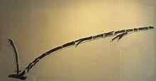
The ploughbeam is made from a single oak branch approximately 3 metres (9.8 ft) long. The ploughshare originally measured about 60 centimetres (24 in). The handle is set in a rectangular opening of the share and stabilised by additional wedges. The front part of the share is missing, because the plough had been accidentally cut into several pieces by its finders.
Pollen samples were taken in 1927 for palynological analysis. This showed that the plough dates to the Early Bronze Age at the earliest. Since it represents a fairly developed form of the scratch plough, the Walle find could also date to the later Bronze Age or Early Iron Age.
A similar plough, also of oak and of similar measurements, was found at Papau near Toruń. The scratch plough type is known through finds and images from the Neolithic, the Bronze and Iron Ages, as well as from Hallstatt culture, Etruscan, Greek, and Roman contexts. The basic form is still in use in the Mediterranean region.
Why the Walle Plough had been deposited in a bog is not known. Perhaps it was meant to be temporarily sunk in the bog during the winter, to preserve its wood. In 1983, a roughly 3000-year-old stone axe was found nearby.
After the plough had begun to physically deteriorate around 1937, it was brought to the Lower Saxony State Museum at Hanover for conservation. It is still on display there. The examination of pollen and peat samples indicated that the plough could not be allocated to any period with certainty. Originally it had been estimated to be from the 4th millennium BC, but in the 1950s this was revised to a date around 2000 BC.
A replica of the plough is on display in the Historical Museum at Aurich. At Walle, a stone marks the findspot.
53°29′25″N7°26′33″E / 53.49028°N 7.44250°E
| | This agriculture article is a stub. You can help Wikipedia by expanding it. |

A bog body is a human cadaver that has been naturally mummified in a peat bog. Such bodies, sometimes known as bog people, are both geographically and chronologically widespread, having been dated to between 8000 BC and the Second World War. The unifying factor of the bog bodies is that they have been found in peat and are partially preserved; however, the actual levels of preservation vary widely from perfectly preserved to mere skeletons.

The Sweet Track is an ancient trackway, or causeway, in the Somerset Levels, England, named after its finder, Ray Sweet. It was built in 3807 BC and is the second-oldest timber trackway discovered in the British Isles, dating to the Neolithic. The Sweet Track was predominantly built along the course of an earlier structure, the Post Track.
Walcott is a small village and civil parish on the North Norfolk coast in England between Mundesley and Happisburgh. The name is formed from the Anglian word 'walh' and the Anglo-Saxon 'cot' meaning 'cottage, hut, shelter or den'. The village is 19.1 miles (30.7 km) north east of Norwich, 11.9 miles (19.2 km) south east of Cromer and 137 miles (220 km) north east of London. The village lies 5.6 miles (9.0 km) east of the town of North Walsham.
Wiesmoor is a town in the district of Aurich in the northwest of Lower Saxony. It lies on the Nordgeorgsfehnkanal and is the youngest town in the East Frisia area having been bestowed town rights on 16 March 2006, two days later on 18 March 2006, Wiesmoor celebrated the Centenary of the settlement's founding. The town owes its growth to the industrialisation of the harvesting of peat from the surrounding moors. Wiesmoor holds an annual flower festival and the town is also known as the ‘Flower City’, the name originates from the large numbers of flowers which are grown in the town’s industrial greenhouse. Formerly the greenhouses were heated by waste heat from the now defunct peat burning power station which was located in the city. Wiesmoor also has the official title of a Luftkurort; tourism now plays an important role in the local economy.

Fan Brycheiniog is the highest peak at a height of 802.5 metres (2,633 ft) in the Black Mountain region of the Brecon Beacons National Park in southern Wales. There is a trig point at the peak and on the edge of the escarpment, and nearby, a stone shelter with an inner seat. It lies just inside the historic county of Brecknockshire which gives the mountain its Welsh name. A subsidiary top, less than a kilometre from the summit along the ridge to the northwest, is the highest point of the neighbouring county of Carmarthenshire. Fan Brycheiniog is also within the Fforest Fawr Geopark designated in 2005 in recognition of the area's geological heritage. The views of the moorland and open country to the north are spectacular when the weather is clear, and reveals the isolation of the range, especially when compared with the more popular Pen y Fan range to the east.
The Blytt–Sernander classification, or sequence, is a series of North European climatic periods or phases based on the study of Danish peat bogs by Axel Blytt (1876) and Rutger Sernander (1908). The classification was incorporated into a sequence of pollen zones later defined by Lennart von Post, one of the founders of palynology.

Old Croghan Man is a well-preserved Irish Iron Age bog body found in June 2003. The remains are named after Croghan Hill, north of Daingean, County Offaly, near where the body was found. The find is on display in the National Museum of Ireland in Dublin.

The Haraldskær Woman is the name given to a bog body of a woman preserved in a bog in Jutland, Denmark, and dating from about 490 BC. Workers found the body in 1835 while excavating peat on the Haraldskær Estate. The anaerobic conditions and acids of the peat bog contributed to the body's excellent preservation. Not only was the intact skeleton found, but so were the skin and internal organs. Scientists settled disputes about the age and identity of this well-preserved body in 1977, when radiocarbon dating determined conclusively that the woman's death occurred around the 5th century BC.
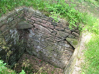
Trapping pits are deep pits dug into the ground, or built from stone, in order to trap animals. European rock drawings and cave paintings reveal that bear, moose and wolf were hunted since the Stone Age using trapping pits. Remains of trapping pits used for hunting elk, reindeer, wolves, and bears can still be found in Northern Scandinavia. These pits, which can measure up to 4 by 7 metres in size and be up to several metres deep, were camouflaged with branches and leaves. They had steep sides lined with planks or masonry, making it impossible for the animal to escape once it had fallen in. When the animal had fallen into the pit, it was killed, either bled to death by sharpened sticks pointed upwards from the bottom of the pit, or in the case of pits without these sticks, dispatched by hunters waiting nearby. Some traps had a small rope enabling rodents and amphibians to escape.

Iron Age Scandinavia was the Iron Age, as it unfolded in Scandinavia. It was preceded by the Nordic Bronze Age.

The Corlea Trackway is an Iron Age trackway, or togher, near the village of Keenagh, south of Longford, County Longford, in Ireland. It was known locally as the Danes' Road. It was constructed from oak planks in 148–147 BC, making it contemporary with the Siege of Carthage.
Ferrybridge Henge is a Neolithic henge near Ferrybridge, West Yorkshire. It is close to the A1 and M62 and Ferrybridge power station. Ferrybridge Henge is the furthest south of Yorkshire's henges, and is the only one in West Yorkshire. The site is of national importance and is protected from unauthorised change as a Scheduled Ancient Monument; despite this it is under threat from ploughing.
The Koelbjerg Man, formerly known as "Koelbjerg Woman", is the oldest known bog body and also the oldest set of human bones found in Denmark, dated to the time of the Maglemosian culture about 8000 BC. His remains are on display at the Møntergården Museum in Odense, Denmark.
The Borremose bodies are three bog bodies that were found in the Borremose peat bog in Himmerland, Denmark. Recovered between 1946 and 1948, the bodies of a man and two women have been dated to the Nordic Bronze Age. In 1891, the Gundestrup cauldron was found in a nearby bog.
Meare Lake Village is the site of an Iron Age settlement on the Somerset Levels at Meare, Somerset, England. It is a Scheduled Ancient Monument.

The Wittmoor bog trackway is the name given to each of two historic corduroy roads, trackway No. I being discovered in 1898 and trackway No. II in 1904 in the Wittmoor bog in northern Hamburg, Germany. The trackways date to the 4th and 7th century AD, both linked the eastern and western shores of the formerly inaccessible, swampy bog. A part of the older trackway No. II dating to the period of the Roman Empire is on display at the permanent exhibition of the Archaeological Museum Hamburg in Harburg, Hamburg.

Torberry Hill is an Iron Age hillfort in the county of West Sussex, in southern England. It is a Scheduled Ancient Monument, with a list entry identification number of 1015966. The hill fort is located within the parish of Harting, within the South Downs National Park. The hill includes the remains of an Early Iron Age univallate hill fort, a Middle Iron Age promontory fort and a post-medieval post mill. The hill is a chalk spur projecting northwards from the South Downs.

Agriculture in prehistoric Scotland includes all forms of farm production in the modern boundaries of Scotland before the beginning of the early historic era. Scotland has between a fifth and a sixth of the arable or good pastoral land of England and Wales, mostly in the south and east. Heavy rainfall encouraged the spread of acidic blanket peat bog, which with wind and salt spray, made most of the western islands treeless. Hills, mountains, quicksands and marshes made internal communication and agriculture difficult.
Over the past four decades, extensive research has been conducted on the Archaeology of Hatfield and Thorne Moors, resulting in the discovery of important Bronze Age and Neolithic trackways. These investigations have been carried out as part of wider initiatives to understand the complex and intertwined social-ecological-climatic systems that has shaped this region over the Holocene. The current landscape has been heavily altered by humans, notably though drainage by Cornelius Vermuyden in the 17th century. This area is notable for its extensive palaeoecological work and serves as a model for other studies in environmental archaeology.

Thundersbarrow Hill is an archaeological site in West Sussex, England. It is on a chalk ridge, aligned north-west to south-east, on the South Downs north of Shoreham-by-Sea.