
Completed in 1796, the Pawtucket Canal was originally built as a transportation canal to circumvent the Pawtucket Falls of the Merrimack River in East Chelmsford, Massachusetts. In the early 1820s it became a major component of the Lowell power canal system. with the founding of the textile industry at what became Lowell.

Waltham Windmill is a six-sailed windmill located in the village of Waltham, five miles from Grimsby in North East Lincolnshire, England. It is renowned in the area for having all six sails still in full working capacity, being one of the very few windmills like this in the United Kingdom.

West Newton is a village of the City of Newton, Massachusetts and is one of the oldest of the thirteen Newton villages. The postal ("Zip") code 02465 roughly matches the village limits.
Walthamstow Marshes, is a 36.7 hectare biological Site of Special Scientific Interest in Walthamstow in the London Borough of Waltham Forest. It was once an area of lammas land – common land used for growing crops and grazing cattle.
The Wal-Lex Recreation Center, or simply Wal-Lex, was an entertainment complex located in Waltham, Massachusetts which operated from 1947 until 2002. Considered a landmark in Waltham and the surrounding area, Wal-Lex consisted of a 60-lane candlepin bowling facility, a rollerskating rink, billiard tables, and video games. It also featured mini-golf until 1985.

Mary Cummings Park is a 210-acre (0.85 km2) public park in Woburn and Burlington, Massachusetts located at Babylon and Whispering Hills. The former farm and estate became a park managed by the City of Boston's Park Department in 1930. Mary Cummings left the land to the City under the condition that it be kept "forever open as a public pleasure ground". Since then it has been used for day camps including "Camp Joy", "Kamp for Kidz" and "Camp Wilderness" and as a public garden for school children called "Woburn Gardens". There are also several miles of trails which are open to the public. A radio controlled model airplane club operates their aircraft on one of the open fields which they maintain.
Founded in Worcester, Massachusetts in 1987, the Greater Worcester Land Trust is a non-profit land conservation organization dedicated to the protection of important lands in Worcester and the surrounding towns. As a conservation land trust the trust's properties are managed simultaneously for wildlife habitat and passive recreation
The Wherehouse, officially titled A. Wherehouse, is a warehouse located at 55 Pond Street in Waltham, Massachusetts, United States. It was rented out by the rock band Aerosmith, starting in 1975 and continuing into the 1980s. The warehouse featured a garage where the band members would park their cars, upstairs offices for the band's personnel, and a ground-level recording studio and stage where the band would often rehearse, write, and record music. The band would also hold meetings here and use the building to rest and relax.

New Covenant Church of Cambridge is located in Waltham, Massachusetts. It is a Haitian church and is headed by the Reverend Esther and the Reverend Thomas St. Louis.

The Charles River Peninsula is a 30-acre (12 ha) nature preserve in Needham, Massachusetts owned and managed by the Trustees of Reservations. The Charles River turns nearly 180 degrees, creating the peninsula. A 20-acre (8 ha) field on the peninsula has been farmed for roughly a century. The original acreage was given in 1960; additional land was given in 1994.

The Malcolm Preserve is an 11-acre (45,000 m2) nature reserve in Carlisle, Massachusetts. It is co-managed by the Trustees of Reservations and the Carlisle Conservation Foundation. Composed of former farmland, there is a half-mile trail and is in close proximity to the Estabrook Woods and the Punkatasset Conservation Land in Concord.

Waltham High School is the only public high school serving the city of Waltham, Massachusetts.
Milk Street is a street in the financial district of Boston, Massachusetts. It was one of Boston's earliest highways. The name "Milk Street" was most likely given to the street in 1708 due to a milk market at the location, although Grace Croft's 1952 work "History and Genealogy of Milk Family" instead proposes that Milk Street may have been named for John Milk, an early shipwright in Boston. The land was originally conveyed to his father, also John Milk, in October 1666.

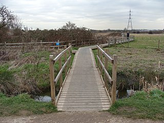
Stony Brook is a stream largely running through Weston, Massachusetts, then forming the Weston/Waltham boundary, and emptying into the Charles River across from the Waltham/Newton boundary. It has two tributaries, Cherry Brook and Hobbs Brook, and its watershed includes about half of Lincoln and Weston as well as parts of Lexington and Waltham. Since 1887, it has been the water supply for Cambridge.
Middlesex County Hospital was a hospital operated by Middlesex County which was operational from the 1930s until 2001 in Waltham and Lexington, Massachusetts. Originally opened as a tuberculosis hospital, the hospital eventually became the county hospital for Middlesex until its closure in 2001. After its closure, it was redeveloped into a condominium complex. It is also located right down the road from the old Metropolitan State Hospital, which also met the same fate as the county hospital.

Fairhaven Bay is a bay located within the Sudbury river in Concord, Massachusetts, United States (US). It was frequented by David Henry Thoreau who, together with Edward Hoar, accidentally set fire to the woods near the bay in April 1844, as later described in Thoreau's journal.
Prospect Hill is a hill in Waltham, Massachusetts, United States, and is the third-highest point within 12 miles (19 km) of downtown Boston. The hill is in Prospect Hill Park on the west side of Waltham, near Route 128. It is exceeded in height by Great Blue Hill and Chickatawbut Hill, both in the Blue Hills Reservation. It is not to be confused with the much lower, historically significant Prospect Hill near Union Square in Somerville.

The Boston Irish Famine Memorial is a memorial park located on a plaza between Washington Street and School Street in Boston, Massachusetts. The park contains two groups of statues to contrast an Irish family suffering during the Great Famine of 1845–1852 with a prosperous family that had emigrated to America. Funded by a trust led by Boston businessman Thomas Flatley, the park was opened in 1998. It has received contrasting reviews and has since been called "the most mocked and reviled public sculpture in Boston".
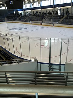
The Bentley Arena is an ice hockey arena on the campus of Bentley University in Waltham, Massachusetts. It is home to the Bentley Falcons men's ice hockey program, replacing the previous facility, the John A. Ryan Arena. The first hockey game was on February 16, 2018 with Bentley taking on Army West Point. The seating capacity for hockey games is 2,207.


