
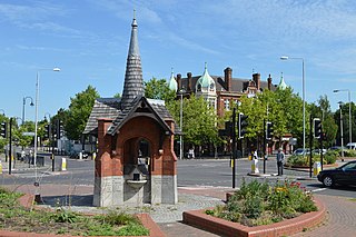
Snaresbrook is a district of East London in the London Borough of Redbridge. It is located 8 miles east of Charing Cross.
Wanstead is an affluent area in east London, England, in the London Borough of Redbridge. It borders South Woodford to the north, Redbridge to the east and Forest Gate to the south, with Leytonstone and Walthamstow to the west. It is located 8 miles northeast of Charing Cross.

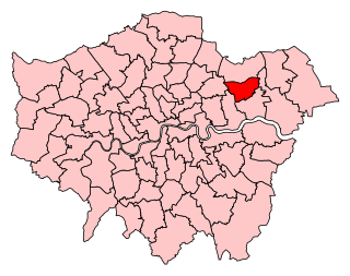
The London Borough of Redbridge is a London borough established in 1965.

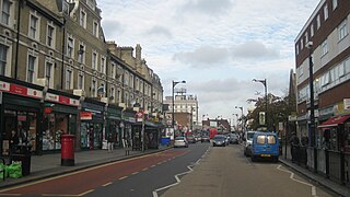
Leytonstone is an area in East London, England, within the London Borough of Waltham Forest. It adjoins Wanstead to the north-east, Forest Gate to the south-east, Stratford to the south-west, Leyton to the west, and Walthamstow to the north-west, and is 7 miles (11 km) north-east of Charing Cross.

Manor Park is a residential area of the London Borough of Newham in east London, England. The area is bordered by Ilford to the east, Forest Gate to the west, Wanstead to the north, and East Ham to the south.

Woodford Green is an area of Woodford in East London, England, within the London Borough of Redbridge. It adjoins Buckhurst Hill to the north, Woodford Bridge to the east, South Woodford to the south, and Chingford to the west. Epping Forest runs through Woodford Green in the west of the area, 9.4 miles (15.1 km) north-east of Charing Cross.

Wanstead Park is a railway station in Forest Gate, London. It is on the Gospel Oak to Barking line in Zone 3, 11 miles 11 chains (17.9 km) down the line from Gospel Oak and situated between Leytonstone High Road and Woodgrange Park. It is operated by London Overground. Despite its name, Wanstead Park Station is not situated in Wanstead but in Forest Gate – and it is not near Wanstead Park but Wanstead Flats. The station was opened 9 July 1894. The station is 360 yards (330 m) from Forest Gate station, according to TfL's journey planner, and this interchange is suggested in the National Rail Timetable.
Forest Gate is a district in the London Borough of Newham, East London, England. It is located 7 miles (11 km) northeast of Charing Cross.

Snaresbrook is a London Underground station on the Central line, located in the area of Snaresbrook in East London. The station is in Zone 4, between Leytonstone and South Woodford stations.
Ilford South is a constituency created in 1945 represented in the House of Commons of the UK Parliament since 2019 by Sam Tarry of the Labour Party.

Wanstead is a London Underground station in Wanstead in the London Borough of Redbridge, east London. on the Hainault loop of the Central line. Towards Central London the next station is Leytonstone. Towards Woodford it is Redbridge. It is in Travelcard Zone 4. It opened on 14 December 1947 as an extension of the Central line to form the new part of the Hainault loop.

South Woodford is an area of East London, England, within the London Borough of Redbridge. It adjoins Woodford Green to the north, Walthamstow to the west, Snaresbrook and Wanstead to the south and Redbridge to the east, and is 8.9 miles (14.3 km) north-east of Charing Cross. Epping Forest runs adjacent to South Woodford in the west of the area.

Upton Park is an area of the East London borough of Newham, centred on Green Street which is the boundary between West Ham and East Ham. West Ham United Football Club formerly played at the Boleyn Ground, commonly known as Upton Park.

Leyton and Wanstead is a constituency in Greater London created in 1997 and represented in the House of Commons of the UK Parliament since 2010 by John Cryer of the Labour Party.
Cann Hall is a former civil parish in the south of Leytonstone in the London Borough of Waltham Forest. It is north of Stratford and Forest Gate, east of Leyton, and west of Wanstead Flats, the southernmost tip of Epping Forest.

Wanstead Flats is the southernmost portion of Epping Forest, in Leytonstone and Wanstead, London. The flats and by extension the forest ends at Forest Gate directly to the south. It now falls wholly within the boundaries of the London Boroughs of Redbridge and Waltham Forest, though until 1994 two parts of it were in the London Borough of Newham: one of these was the section between Aldersbrook Road and Capel Road east of the junction between Aldersbrook Road and St Margaret's Road, whilst the other was the strip running along Capel Road between its junctions with Centre Road and Ridley Road. As part of Epping Forest, the Flats is managed by the City of London Corporation.

Wanstead and Woodford was a local government district from 1934 to 1965 in southwest Essex, England. A merger of two former urban districts, it was suburban to London and part of the Metropolitan Police District.

Wanstead Park is a municipal park covering an area of about 140 acres, in Wanstead, in the London Borough of Redbridge. It is also a district of the London Borough of Redbridge, which was in Essex until 1965.

Woodford is a town in East London, within the London Borough of Redbridge. It is located 9.5 miles (15.3 km) north-east of Charing Cross. Woodford historically formed an ancient parish in the county of Essex. It contained a string of agrarian villages and was part of Epping Forest. From about 1700 onwards, it became a place of residence for affluent people who had business in London; this wealth, together with its elevated position, has led to it being called the Geographical and social high point of East London. Woodford was suburban to London and after being combined with Wanstead in 1934 it was incorporated as a municipal borough in 1937. It has formed part of Greater London since 1965 and comprises the neighbourhoods of Woodford Green, Woodford Bridge, Woodford Wells and South Woodford. The area is served by two stations on the Central line of the London Underground: Woodford and South Woodford.